


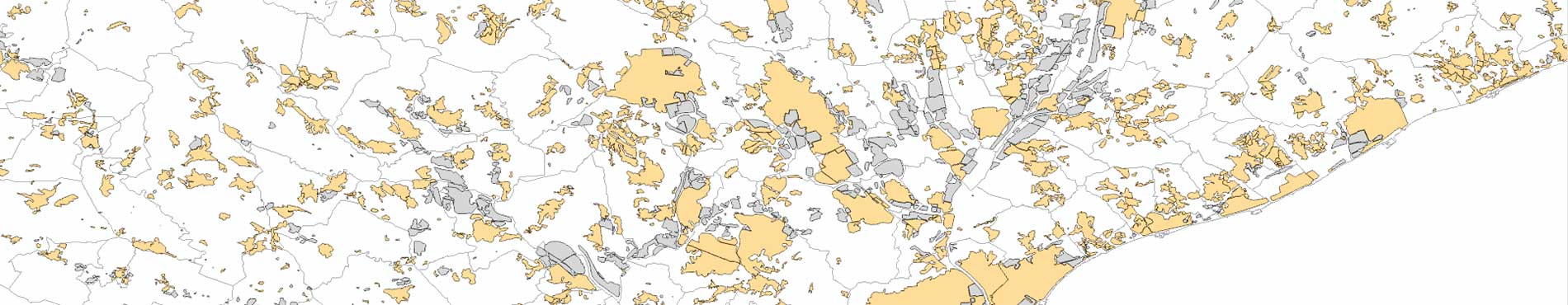
Population areas
Population areas of the Geographical Names Database of Catalonia and Nomenclature of Municipalities and Population Entities, building clusters, and the polygons that appear in the Economic Activity Polygon Information System
Geographical areas of settlement that appear in the Geographical Names Database of Catalonia and the Nomenclátor of Municipalities and Population Entities, as well as building clusters and the polygons that appear in the Economic Activity Polygon Information System, with their names and codes and the administrative divisions where they are located.
The interpretative delimitation of the Population areas includes the representation and location of buildings and constructions with a defined urban structure and the groupings of buildings including the associated spaces that respond to the same geographical name.
| Geoinformation from the Cartographic and Geological Institute of Catalonia subject to a Creative Commons Attribution 4.0 International license (CC BY 4.0) More information |
Technical characteristics
- The layer is distributed in Geopackage format, and can also be used through the associated WMS.
- The coordinate system adopted is the official one in Catalonia (ETRS89 UTM 31 North).
For the correct visualization of the data with the predefined style and other considerations, we suggest consulting the manuals included (appendices) in the technical specifications of this geoinformation.
Description
Population areas are human settlements made up of fixed, covered, and stable buildings over time, including roads, bodies of water, parks, and other elements of the territory that form part of the settlement.
Population areas are selected from population entities in the Geographic Names Database of Catalonia (ICGC) and the Nomenclátor de municipios y entidades de población (INE), and also from SIPAE in the case of industrial sectors.
Additionally, based on the Territorial Topographic Reference (RTT), concentrations of 15 buildings (larger than 50 m²) or more are identified, provided that they are separated by no more than 50 m from each other. If any of these clusters is located less than 50 m from an already listed settlement area, it is merged with it.
To complete the industrial sector, those toponyms associated with certain industrial concepts are selected from the Geographic Names Database of Catalonia (see the technical specifications for more details).
The polygons are delimited on the territorial topographic reference (streets, roads, plots, buildings, etc.), taking into account the administrative divisions, and are finally adjusted by photointerpretation on the current orthophoto (introduction of buildings, etc.), whenever possible, to planimetric elements of the territory such as roads, plots, buildings, etc.
If it is a question of industrial sectors that are in the SIPAE, the delimitations that appear there (in the SIPAE) are taken as a basis and then they are adjusted like the rest of the settlement areas.
Then, the name that appears in the Geographical Names Database of Catalonia is associated with each area, or the one that appears in the SIPAE in the case of industrial sectors not included in the Geographical Names Database. Finally, a specific code is also associated for each area, the codes of the INE entities where it is located (if the area is included in the INE's Nomenclature of Population Units), and information on the administrative divisions where it is located.
The final result is a layer of polygons that delimit the existing population areas in Catalonia, including economic activity polygons, with their names and codes.
Case studies
Facilitate the graphic representation, consultation and analysis of statistical data (population, economic, environmental, etc.), and serve as a reference base for planning aspects related to the territory, in which it is essential to know the areas with urban structure.
One of the main uses of this geoinformation is territorial and urban planning in Catalonia. By studying the territorial scope of populated areas and their distribution, together with the classification and qualification of the land, the activities carried out there, the population and other data, it is possible to order urban growth, protect the environment, optimize mobility, guarantee a balanced distribution of services and promote economic development. A specific example would be the identification of population centers with urban deficits, lack of facilities or access to high-speed Internet.

The assessment of natural risks, such as fires or floods, is another area in which the delimitation of populated areas is essential. In the case of fires, the identification of settlements (urbanizations, etc.) in forest environments facilitates the promotion of prevention work such as the establishment and implementation of perimeter protection strips. Regarding floods, the crossing of populated areas with hydrographic data, among others, helps to implement resilience actions (construction of walls, adaptation of infrastructures, etc.), beyond reviewing the corresponding urban planning to avoid possible catastrophes.
Video [52:38]