


GeoAI-Cubes: training Artificial Intelligence for Earth Observation
Datasets for thematic classification and change detection
GeoAI-Cubes is a spatial and temporal database from different sensors designed to provide pre-processed information from a variety of Earth observation systems or external data fully aligned at the pixel or tile scale.
Geoaicube is an initiative promoted by the Catalonia Space 2030 Strategy.
The dataset is optimized to efficiently train artificial intelligence models focused on geospatial applications. All Geoaicube data is in Zarr format, georeferenced in the same WGS84 UTM31N projection and covering the same geographical extent and with the labeling of the Land Cover Map of Catalonia, major changes 2023:
- UTM X West: 427000.
- UTM X East: 459000.
- UTM Y North: 4630900.
- UTM Y South: 46113000.
Reuse of information
| The use of the data is subject to a Creative Commons Attribution 4.0 International license. More information |
Contains Sentinel Copernicus data modified by the ICGC.
It is requested that all methodologies and results obtained by the different scientific groups be shared with the ICGC via email: icgc@icgc.cat.
Viewer
Dataset Description
The following cartographic and additional information layers have been converted to ZARR format (more efficient for data ingestion processes into AI models):
- Geodatacube_orto2024.zarr: 25 cm resolution (32.9 GB).
- Geodatacube_S22024_2025.zarr: 10 m resolution (1.19 GB).
- GeoDataCube_access_XARRAYvsZARR_cat.ipynb: Jupyter Notebook explaining access to information in zarr format.
- Field_ROI_geodatacube.gpkg: GPKG of crop 1 for Sentinel-2 time series analysis in the notebook.
- Field2_ROI_geodatacube.gpkg: GPKG of crop 2 for Sentinel-2 time series analysis in the notebook.
- bbox_epsg32631.geojson: File in geojson format of the geographic scope.
The usability of GEOAICUBES, happens in I.A. to have good labels. The proposal is that these come together with the publication of the aforementioned geoaicubes (high and low resolution) with the labeling of the Land Cover Map of Catalonia, major changes 2023.
Download
The data can be downloaded directly from the address https://datacloud.icgc.cat/datacloud/geodatacubes.
Due to the large volume of files available, it is recommended to download using the FTP client.
Server: ftp.icgc.cat | User: descarregues01 | Password: descarregues01
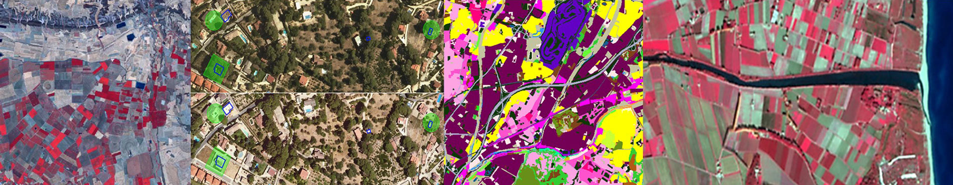
Examples of the available set of images
| Sentinel 2 RGB | Orthoimage RGB | nDSM |

| 
| 
|
| Sentinel-2 IRC | Orthoimage RGB IRC | |

| 
|
| Land cover map | Legend | |||||||
|---|---|---|---|---|---|---|---|---|
| Graphic representation | Class | Name | Color | Hex code | Class | Name | Color | Hex code |

| 1 | Herbaceous crops | #ffff00 | 22 | "Eixample" | #FF53CD | ||
| 2 | Vegetable gardens, nurseries and forced crops | #CCFF33 | 23 | Lax urban areas | #FFA4E2 | |||
| 3 | Vineyards | #AF5B15 | 24 | Isolated buildings in rural areas | #FFC8E2 | |||
| 4 | Olive groves | #808000 | 25 | Isolated residential areas | #FFB4B4 | |||
| 5 | Other woody crops | #CDCD00 | 26 | Green areas | #0F3700 | |||
| 6 | Crops in transformation | #FFFFCC | 27 | Industrial, commercial and/or service areas | #730055 | |||
| 7 | Dense coniferous forests | #33CC33 | 28 | Sports and leisure areas | #6200C4 | |||
| 8 | Dense deciduous, broadleaf forests | #66FF33 | 29 | Mining and/or landfill areas | #4A9595 | |||
| 9 | Dense sclerophyll and laurel forests | #689018 | 30 | Zones in transformation | #FF00F0 | |||
| 10 | Scrub | #967D5F | 31 | Road network | #19E61E | |||
| 11 | Open forests of conifers | #19E61E | 32 | Urban bare soil | #FFE6E6 | |||
| 12 | Deciduous, broadleaf open forests | #B4FF9B | 33 | Airport areas | #67629A | |||
| 13 | Sclerophyll and laurel open forests | #AAA500 | 34 | Railway network | #4A466E | |||
| 14 | Meadows and grasslands | #C3C3A0 | 35 | Port areas | #2F2D46 | |||
| 15 | Riverside forest | #00FF9B | 36 | Reservoirs | #6F6FFF | |||
| 16 | Sòl nu forestal | #FF9632 | 37 | Lakes and lagoons | #0000DC | |||
| 17 | Burnt areas | #282828 | 38 | Watercourses | #000064 | |||
| 18 | Rocks and swamps | #79797A | 39 | Ponds | #185F94 | |||
| 19 | Beaches | #F5DF78 | 40 | Artificial canals | #12466D | |||
| 20 | Wetlands | #3296FF | 41 | Sea | #000080 | |||
| 21 | Urban center | #FF007D | 0 | Outside the border | #ffffff | |||