


Local orthophoto
Mosaic of high-resolution aerial photographs of urban areas, both in color (RGB) and in color infrared (IRC)
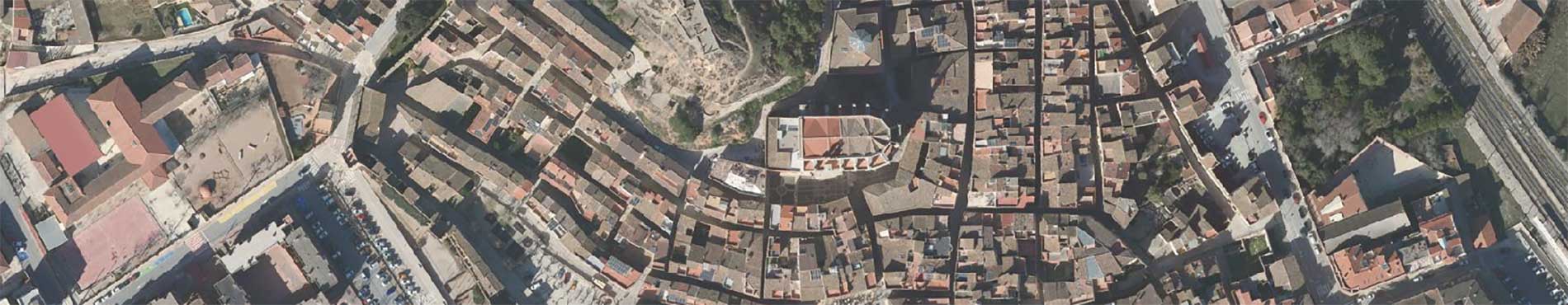
The Local Orthophoto is a set of aerial images, obtained from photogrammetric flights, geometrically rectified using aerotriangulation techniques. The result is what is called an expedited orthophoto, which mainly covers urban areas and has a very high resolution of 10 cm above the ground.
The geometric rectification of the aerial photographs ensures that each point in the image coincides exactly with its real position in the territory.
It is available in color (RGB) and color infrared (IRC).
Technical characteristics
- These orthophotos, available in color and color infrared, have a spatial resolution of 10 cm (each pixel of the image is equivalent to 10 cm of the territory) and are distributed in 8-bit COG (Cloud Optimized GeoTIFF) format. They can also be used through the associated WMS, for visualization in applications compatible with this protocol.
- The coordinate system used is the official one in Catalonia (ETRS89 UTM 31 North).
For the correct visualization of the data with the predefined style and for other considerations, we suggest that you consult the manuals included (appendices) in the technical specifications of this geoinformation (Catalan).
| Geoinformation from the Cartographic and Geological Institute of Catalonia subject to a Creative Commons Attribution 4.0 International license (CC BY 4.0) More information |
Description
The local orthophoto is a set of aerial images, obtained through photogrammetric flights, geometrically rectified using aerotriangulation techniques. The result is what is called an expedited orthophoto, which mainly covers urban areas and has a very high resolution of 10 cm above the ground.
It is available in color (RGB) and color infrared (IRC).
This orthophoto is generated with the geometric rectification, based on an aerotriangulation process, of the images obtained by a photogrammetric aerial camera. For this rectification, the terrain elevation model derived from the Territorial Topographic Reference or another one of similar or better precision is used.
If very obvious foreign bodies are detected or that may prevent the interpretation of relevant urban elements, which may have originated during the orthophoto generation process or during the acquisition of the images, digital retouching techniques are applied.
The final result is aerial images of various urban areas of Catalonia, in COG format (Cloud Optimized GeoTIFF), which can be opened with any image software and, if you want to work from a cartographic point of view, using any GIS and CAD software.
The COG format reduces the size of the files and, in addition, includes the internal georeferencing of the image, that is, its coordinates.
Case studies

The main objective of this type of orthophoto is municipal management, as it allows the superposition of vector geoinformation for carrying out studies in various areas that require a lot of detail, especially in urban areas. Given its degree of detail (each pixel of the image is equivalent to 10 cm of the territory), small construction elements, horizontal signage, etc. can be identified; and also measure their surface and distances. In addition, its availability in color infrared adds the possibility of additional analysis, especially regarding vegetation (for example, it allows distinguishing natural grass from artificial grass).
")
These georeferenced images allow the detection of changes in land use, such as the transformation of green spaces into built-up areas, and facilitate decision-making in urban planning projects, such as the delimitation of new roads or the planning of public facilities. In addition, their high resolution and precision make them very useful for the supervision of certain urban modifications and the monitoring of the environmental impact within the urban fabric.

Another specific use of orthophotos in urban areas is in mobility projects. Administrations and service companies use them to analyze the distribution of road infrastructure, such as bike lanes, and to plan improvements in urban connectivity. Orthophotos allow for the precise visualization of the relationship between built spaces and communication routes, which facilitates the study of mobility flows and the detection of conflicting or poorly connected points. They are also useful for traffic management, as they help identify areas with high vehicle density or accessibility problems. This type of analysis is key to promoting more sustainable and efficient mobility in dense urban environments.