



3D geological model of the Vallès Basin
3D Modelling for the Assessment of Available Deep Geothermal Resources in the Vallès Basin
ICGC generates 3D subsurface baseline information on the nature and structure of the underground to help address the future challenges posed by climate change scenarios in terms of water supply and decarbonisation.
Therefore, within the framework of the project GeoEnergia: Deep Geothermal Energy (GeoEnergia-GP), whose objective is to advance towards the quantification of the baseline energy resources available in Catalonia, the 3D Geological Model of the Vallès Basin has been developed and published.
This area is known for the presence of deep geothermal resources and is identified and classified in the document "Deep Geothermal Resources in Catalonia (RGOPCat): Synthesis of Their Potential" (ICGC, 2025). Three main types of potential resources are recognised:
- Resources associated with hydrothermal anomalies related to fault zones along the basin margin (Vallès Fault), identified in La Garriga, where thermal waters reach 61°C; in Caldes de Montbui, where thermal springs and boreholes such as Font del Lleó yield waters at 71°C; and in Cànoves i Samalús, where former geothermal exploration wells recorded water temperatures of up to 89°C at a depth of 1,000 m (SA-6).
- Resources associated with the potentially fractured granite basement aquifer located in the centre of the extensional basin.
- Resources associated with deep sedimentary reservoirs, including the Tertiary aquifers in the centre of the Neogene extensional basin and, in the southwestern sector of the basin, the Mesozoic aquifers (Triassic carbonate formations).
The 3D Geological Model of the Vallès Basin presented here comprises the modelling of the subsurface in the central and eastern sectors, from the Sabadell area to Sant Celoni, with a particular focus on defining the northern margin, including the Vallès-Penedès Fault and the La Garriga thrust sheet, as well as the geometry of the granite basement. Its main objective is to synthesise the available information and generate a model that will serve as a basis for the future assessment of the deep geothermal potential of reservoirs associated with the basin-centre aquifers, as well as the hydrothermal anomaly associated with the Vallès-Penedès Fault along the basin margin.
The Reservoirs of the Vallès Basin
The Vallès Basin forms part of a set of extensional basins with a SW-NE orientation that make up the central axis of the Catalan Coastal Ranges. The basin has a strongly developed half-graben geometry towards its northwestern margin, where it is bounded by the Vallès-Penedès Fault.
Within the model area, the Miocene sedimentary infill of the basin lies unconformably over the Palaeozoic basement, consisting of Cambro-Ordovician metasedimentary rocks and Late Variscan intrusive units. In the footwall block of the Vallès-Penedès Fault, the dominant structure is the La Garriga thrust, with north-northwestward displacement and a Palaeogene age, resulting in the superposition of Palaeozoic rocks, predominantly granitic in nature, over the Mesozoic and Palaeogene sedimentary cover of the Ebro Basin.
In this sector, owing to their favourable hydrogeological characteristics for exploitation, the following potential reservoirs have been identified:
- Deep Tertiary aquifers in the centre of the extensional basin. In the Vallès Basin, these reservoirs are associated with Upper Miocene detrital deposits.
- Aquifer associated with potentially fractured granite basement levels: the Vallès granite batholith constitutes a potential petrothermal reservoir for geothermal purposes, taking into account the potentially high degree of fracturing within the granitic body, resulting from the area's complex structural evolution through successive compression and extension events.
- Finally, resources associated with convective hydrothermal circulation systems from the deepest parts of the basin through a fractured zone with enhanced permeability due to the intersection of multiple fault systems. It is assumed that the Vallès granite batholith extends at depth, exhibiting significant fracturing and depth extent, while the fractured zone corresponds to the intersection of the Vallès-Penedès Fault with other geological structures, such as the La Garriga thrust.
Hydrothermal resources have been identified along the northern margin of the Vallès Basin and are currently exploited at Caldes de Montbui and La Garriga. In addition, several geothermal exploration campaigns have been carried out within the Vallès Basin, resulting in the drilling of boreholes and exploration wells that recorded water temperatures of up to 89°C at a depth of 1,000 m (SA-6).
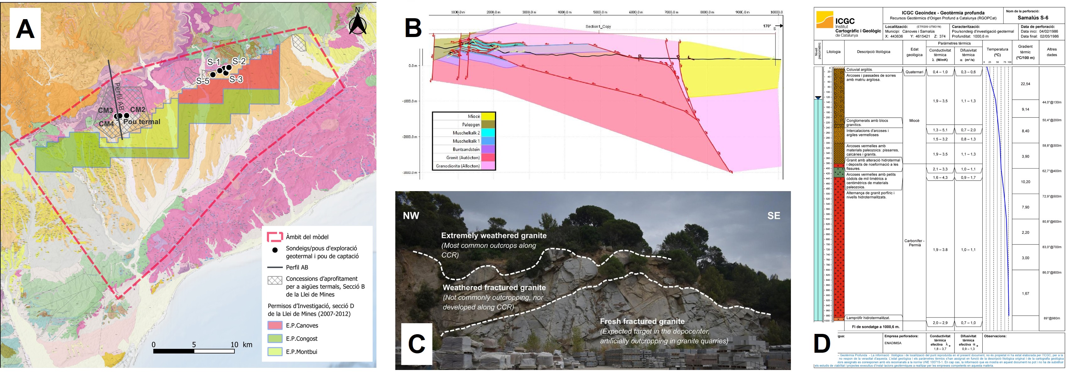
(A) Regional geological map of the Vallès Graben and geological framework; (B) Schematic cross-section of the Caldes de Montbui area; (C) Granite outcrop in a quarry showing a weathering profile; (D) Lithological log of the S-6 exploration well/borehole (modified from APEX, 1976).
Construction of the 3D Geological Model
The geological model was developed following the work phases described below:
Compilation of the available information, interpretation of existing datasets and implementation of new field campaigns to validate the surface geology. Acquisition of new geophysical measurements (H/V spectral ratio and gravimetric data) enabled the densification of existing datasets and improved knowledge of the subsurface.
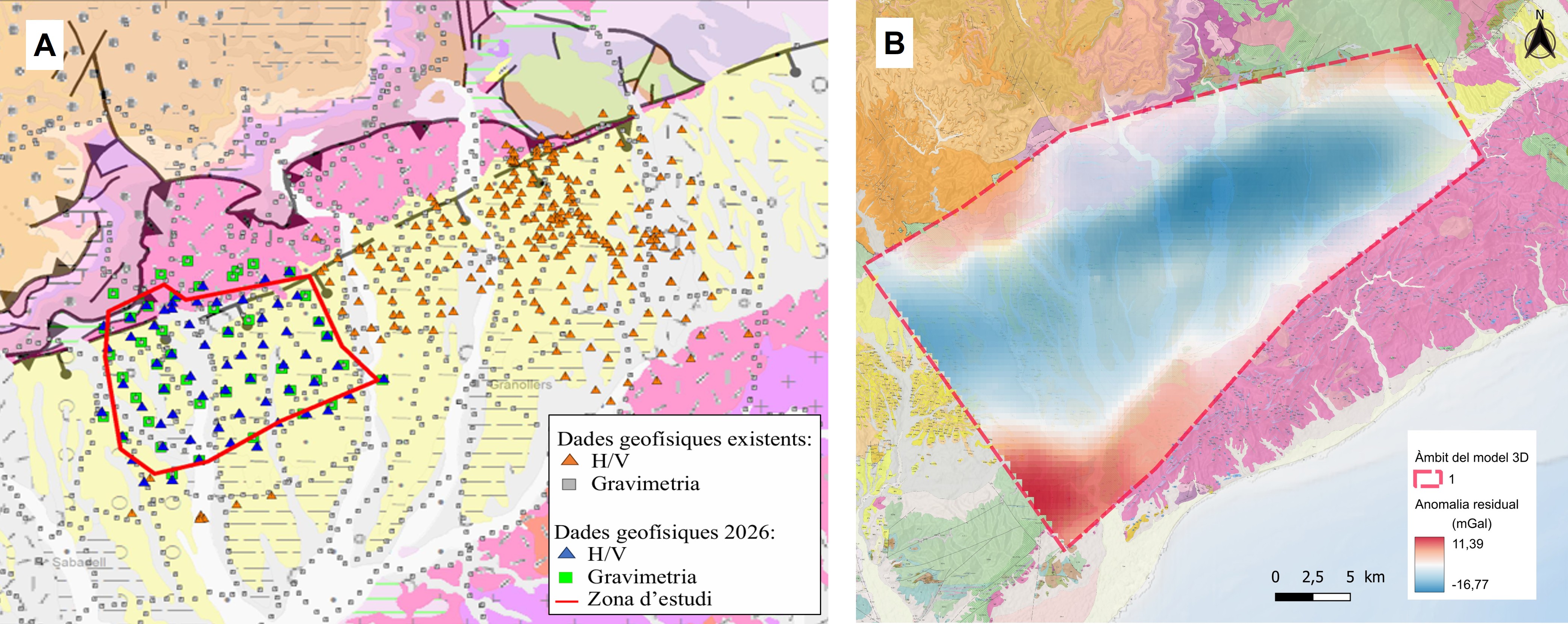
(A) Distribution map of existing geophysical data and new data acquired during the 2026 survey; (B) Residual anomaly obtained from the model area.
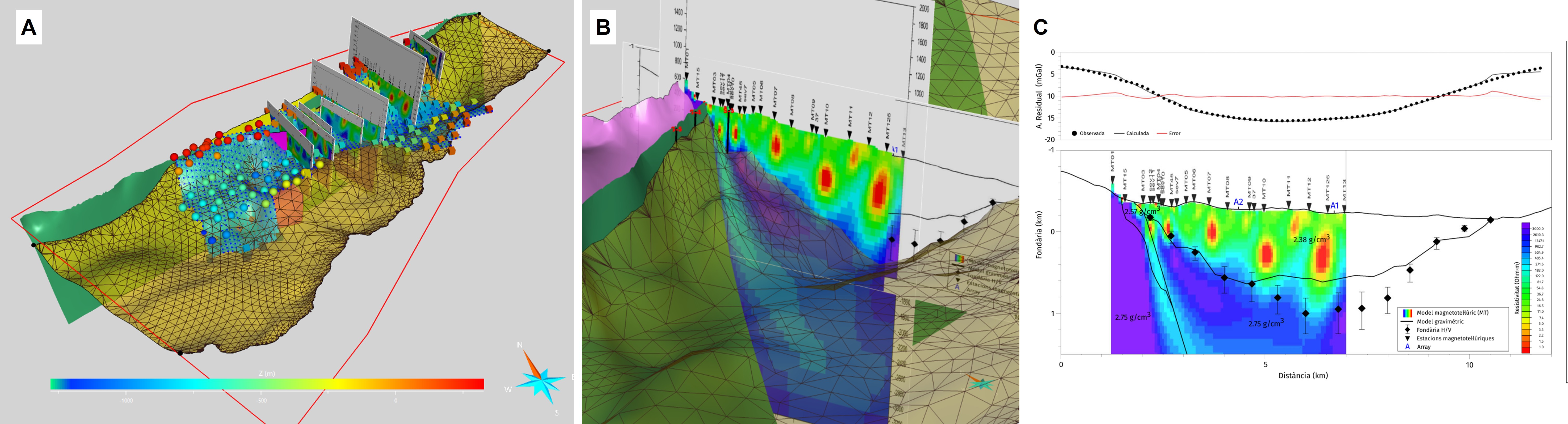
(A) 3D view showing H/V measurement points, the interpreted seismic basement surface, and magnetotelluric (MT) profiles over the Upper Neogene basal surface; (B) Detailed view of the 3D model showing the integrated geophysical profile in the Samalús sector; (C) Integrated geophysical profile in the Samalús sector including the MTII model, the gravity model, and basement depth derived from H/V data.
- Integration of previously available geological information to create an initial 3D geological model of the study area using Aspen SKUA v.15 (5.0.0.0) by AspenTech, allowing the construction of the main lithological and structural surfaces and several geological cross-sections.
- Integration of gravimetric data for the adjustment and validation of the 3D voxet geological model through geophysical data inversion. This phase, carried out using 3DGeomodeller® (version 4.2.0, Intrepid Geophysics), consists of iteratively calculating the probability that each cell in the voxet model corresponds to a given lithological unit based on initially assigned petrophysical properties, until the best fit with the measured geophysical data is achieved. This stochastic procedure allows validation of the geological model.
Finally, Aspen SKUA v.15 (5.0.0.0) was used to generate the complete 3D geological model, including stratigraphic and structural surfaces and the solids representing the lithostratigraphic units.
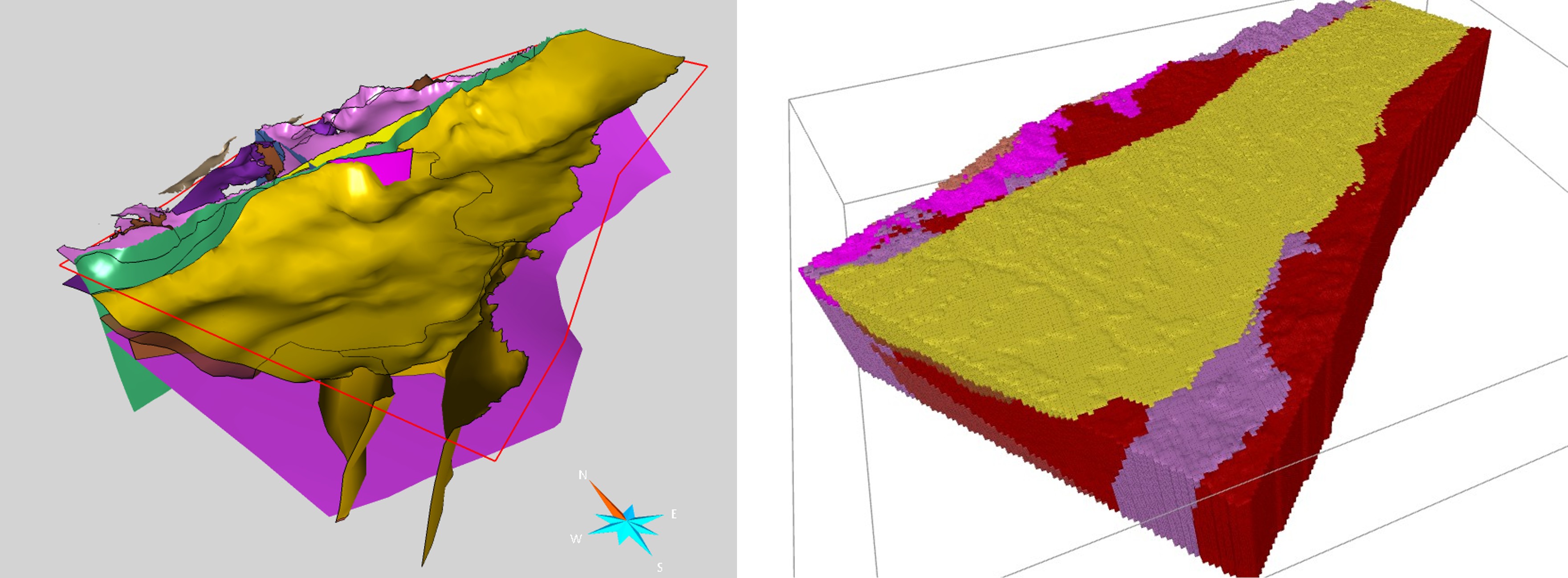
Images illustrating the construction of the initial 3D geological model: preliminary surface model prior to geophysical inversion (left); and the most probable geological model obtained after the inversion process (right).
Results and Conclusions
The 3D geological model, including lithological and structural surfaces and the distribution of the three modelled reservoirs, can be explored and visualised in the Geoindex - 3D Geological Resources Viewer.
- Deep Tertiary aquifers in the centre of the extensional basin. In the Vallès Basin, Upper Miocene detrital deposits reach a maximum thickness of approximately 1,500 m. According to the model, two depocentres are recognised: one in the Sabadell-Sentmenat sector (maximum depth of 1,500 m) and another in the Cardedeu sector.
- Potentially fractured granite basement aquifer: the Vallès granite batholith makes up most of the basin subsurface and constitutes a potential petrothermal reservoir for geothermal use, considering the high degree of fracturing of the granitic body resulting from the area's complex structural evolution through successive compression and extension events.
Resources
Data Visualisation and Formats
References
- Arnó, G.; Herms, I.; Colomer, M.; Fleta, J.; Camps, V.; Conesa, A. (2025). Deep Geothermal Resources in Catalonia (RGOPCat): Synthesis of Their Potential. ICGC Geoindex – Deep Geothermal Energy (Version v2.0; ICGC, 2025). Institut Cartogràfic i Geològic de Catalunya.
- ICGC (2023). Geophysical Database of Catalonia. 2013. Available online: Geoindex - Geophysical Techniques (last accessed on 7 July 2023).
- Piris, G., Herms, I., Griera, A., Colomer, M., Arnó, G., & Gomez-Rivas, E. (2021). 3DHIP-calculator: A New Tool for the Stochastic Assessment of Deep Geothermal Potential Using the Heat-in-Place Method from Voxel-Based 3D Geological Models. Energies, 14(21), 7338.