


Coastal elevation models
High resolution elevation models of the coast of Catalonia
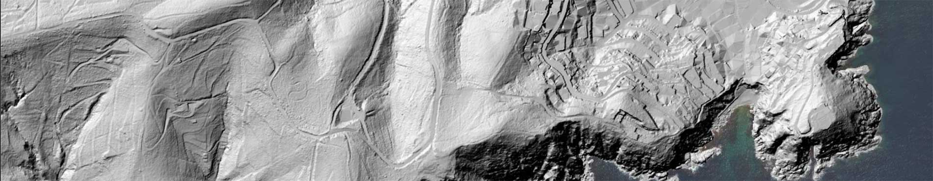
The ICGC offers two high-precision elevation models for the Catalan coastline: the Digital Terrain Model (DTM) and the Digital Surface Model (DSM), with a resolution of 50 cm and coverage up to 500 m from the coast. They are generated from LiDAR flights, which provide a georeferenced and classified point cloud to separate terrain, buildings, vegetation and water.
The DTM represents the natural topography, while the MDS includes all surface elements. Since 2022, two flights are made annually and additional after storms to ensure updates for analysis and strategic planning.
| Cartography subject to a Creative Commons Attribution 4.0 International license (CC BY 4.0). More information |
Last update
- Publication date: March 2026.
- Information date: 2014, 2015, 2016, 2017, 2022, 2023 and 2024.
- Version: v1.0.
Description
The ICGC offers two fundamental products for coastal management and analysis: the DTM and the DSM. These models cover the coastal strip up to 500 meters from the coastline and have a resolution of 50cm per pixel in models from 2021 and 1 meter for historical models, which makes them a source of high-precision information for environmental studies, territorial planning and scientific research.
The models have been generated from periodic flights with LiDAR technology, a system that emits laser pulses towards the earth's surface and measures the return time to calculate the distance with great accuracy. This technique allows for obtaining a dense and detailed point cloud, which is subsequently georeferenced to locate each point in real coordinates and classified to eliminate noise and separate the points into different categories: terrain, buildings, vegetation and water.
- DTM: represents the bare surface of the land, without elements such as buildings or vegetation. To generate it, only points classified as terrain have been used, ensuring an accurate representation of the natural topography. This model is essential for applications such as hydrological modeling, flood risk analysis and geomorphological studies.
- DSM: shows the surface as perceived by sensors, including buildings, vegetation and other elements. All valid points in the LiDAR cloud have been used for its creation.
Since 2022, the ICGC has been carrying out two LiDAR flights per year (winter and autumn) to ensure a constant update of the models, as well as additional flights after storms or exceptional phenomena. Although this data can be collected after extreme episodes, the products are intended for subsequent analysis and strategic planning, not for immediate actions. In addition, this product is complemented by historical LiDAR flights carried out since 2008, which are also being processed to generate elevation models. This information provides an extensive time series, essential for analyzing long-term trends, comparing the evolution of the coastline and validating predictive models with real data accumulated over more than a decade.
Technical characteristics
- DTM product: Accurate representation of the topography without surface elements.
- DSM product: Representation of the surface with all visible elements (buildings, vegetation, etc.).
- Coverage: Coastal strip of Catalonia up to 500 m from the coastline.
- Data source: LiDAR point cloud captured in periodic flights over the coast of Catalonia.
- Resolution: 0.5m pixel in models from 2021 and 1 m pixel in historical models.
- Reference system: EPSG: 25831.
- Format: GeoTIFF (raster). Null values: -9999.
- Update: Twice a year (winter and autumn) more specific for coastal storms, more historical data.
Use cases
Impact Analysis and Coastal Dynamics
Models are a key tool for studying the effects of storms, coastal erosion and the evolution of beaches and dunes. They allow us to quantify changes in coastal morphology, assess sand loss and plan future actions to reduce risks. They are also useful for environmental restoration and habitat management programs. Therefore, they are essential data for monitoring coastal dynamics, including beach regression and the transformation of coastal ecosystems, as well as for evaluating the effectiveness of corrective measures and conservation strategies.
They also facilitate the assessment of flood zones and the definition of preventive measures to minimize the impact on vulnerable areas.
")
Winter 2023-2024 Calella Beach (Maresme)
Volumetric studies
LiDAR point clouds are a fundamental tool for calculating volumetrics in coastal environments, such as the volume of sand on beaches, dunes or artificial breakwaters. These data allow monitoring the loss or gain of sediments after storms, planning regeneration actions and evaluating the effectiveness of coastal protection infrastructures.
The precision of the models derived from LiDAR ensures a reliable estimate in highly dynamic areas.
")
Hivern 2024 Cala Mora (Tarragonès)
Vegetation study
LiDAR data captured on the coastal strip allows the characterization of coastal vegetation, such as dunes with plant cover, wetlands or protected natural spaces. The classification of points makes it easier to distinguish between terrain and vegetation, which allows the calculation of heights, density and structure of the plant cover.
This information is key for the management of coastal habitats, monitoring of regeneration processes and evaluation of the effect of storms on vegetation.
")
Winter coast 2022 Punta Canyadell (Arenys de Mar, Maresme)