


510 results found
Imatge

Flooding studies carried out at the local level (left figure) and at the regional level (right figure). Update date: August, 2017.
Imatge

Examples of study areas. In the left photograph, detail of the upper section of the Noguera Ribagorçana (2008), and in the right photograph, detail of the Llobregat River, as it passes through Gironella (2006), during the work of the Planning of Fluvial Spaces of Catalonia (PEFCAT).
Imatge
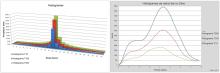
Hyetogram and calculation hydrograph obtained from the hydrological study
Imatge

Location map of the 14 projected new construction points of the XEGCat of Tarragona (Primary subnetwork)
Imatge

Imatge

Installation process of the Llívia station (Cerdanya)
Imatge

Sensor installation process at 5, 20, 50 and 100 cm