


3D hiking routes in Catalonia
Tool that allows you to find, view, animate, upload your own itineraries and download predefined excursion itineraries
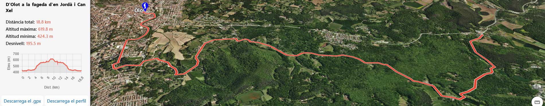
The 3D hiking routes in Catalonia viewer is an interactive tool developed by the ICGC that allows you to find, visualize, animate and download predefined hiking routes in a three-dimensional environment. This viewer facilitates detailed exploration of the Catalan territory and offers an immersive experience for users interested in planning excursions and getting to know the terrain better.
The main objective of this viewer is to provide an advanced visual platform that allows users to explore and analyze 3D hiking routes in Catalonia, improving the understanding of the relief and geographical characteristics of the territory.
The 3D hiking routes in Catalonia viewer is designed primarily for hikers, but it can also be useful in the educational and territorial management fields.
Technical data
The data used in the viewer includes detailed topographic information (orthophotos and vector cartography from the ICGC), digital terrain models and routes in standard formats such as GPX. 3D rendering techniques are used to generate a realistic representation of the landscape.
The routes come from the transparency portal of the Generalitat de Catalunya (2022).
Features
- 3D visualization and navigation.
- Upload a route and download predefined routes in GPX format.
- Image generation and download.
- Route sharing.
Viewer