



Soriguera seismic station (CSOR)
Code: CA.CSOR Nom: Soriguera Latitude: 42.3744 N Longitude: 1.1327 E Height: 1227 m Fondària local: 1.7 m Owner: Institut Cartogràfic i Geològic de Catalunya |
| Subsoil features | ||||
|---|---|---|---|---|
| Lithology | Period | Vs30 (m/s) | Classe EC8 | F0 (Hz) |
| Limestones and lutites | Devonian | 1694 | A | - |
| Instrumentation by channels and periods | ||||
|---|---|---|---|---|
| Channels | Start date | Sensor type | Digitizer type | Instrumental response |
| HHZ, HHN, HHE | 01/12/2001 | Broadband velocimeter | 24 bits | [StationXML] |
Geophysical characterisation
H/V Spectral ratio from seismic noise
H/V Spectral ratio from seismic noise records of Soriguera seismic station. It is observed an almost flat curve, without any significant peak which might be associated to the fundamental frequency of the soil. This behaviour is typical of rock sites.
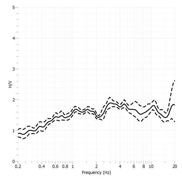
H/V Spectral ratio of seismic noise records from Soriguera seismic station
P-waves velocity model
In the P-waves velocity model, obtained by seismic refraction tomography, significant lateral variations are observed along the seismic profile. In the seismic well sector, velocities higher than 2500 m/s are reached at a depth of about 3 meters, and values higher than 3000 m/s are found at less than 5 meters depth. These high velocity values are associated with unweathered non-ripable rock, and can be interpreted as the bedrock.
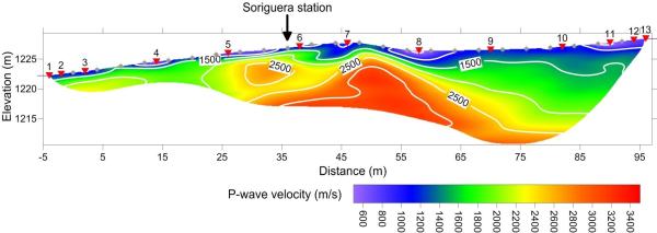
P-waves velocity model of Soriguera seismic station
S-waves velocity model
In the shear wave (VS) propagation velocity model obtained by refractive seismic tomography, significant lateral velocity variations are detected. In the area of the seismic station the bedrock (VS = 1000 m/s) is detected at less than 2 meters depth, and at 3 meters depth it already exceeds 1500 m/s, which are associated with very rock hard.
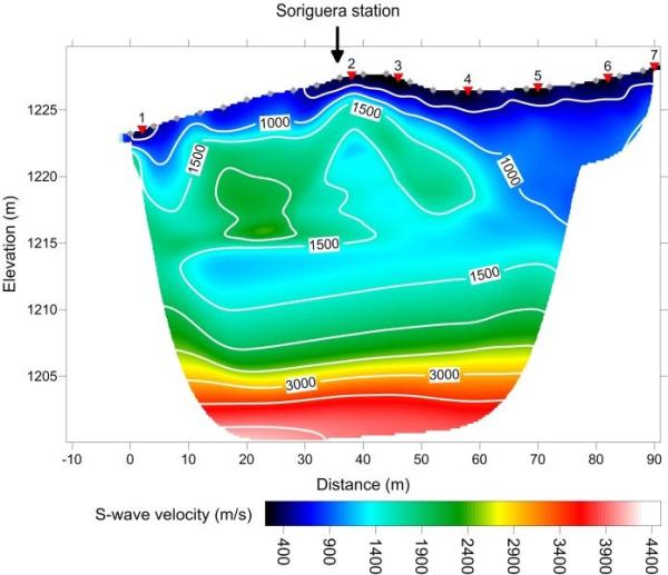
S-waves velocity model of Soriguera seismic station