


La Seu d'Urgell seismic station (EXSEU)
Code: ES.EXSEU Name: La Seu d'Urgell Latitude: 42.3580 N Longitude: 1.4599 E Height: 707 m Local depth: 3 m Owner: Institut Cartogràfic i Geològic de Catalunya, Instituto Geográfico Nacional |
| Subsoil features | ||||
|---|---|---|---|---|
| Lithology | Period | Vs30 (m/s) | Classe EC8 | F0 (Hz) |
| Gravels and silts | Quaternary | 324 | C | 1.0 |
| Instrumentation by channels and periods | ||||
|---|---|---|---|---|
| Channels | Start date | Sensor type | Digitizer type | Instrumental response |
| HNZ, HNN, HNE | 30/07/2019 | Accelerometer | 24 bits | [StationXML] |
Geophysical characterization
H/V spectral ratio of seismic noise
H/V spectral ratio of the seismic noise record at the Seu d’Urgell accelerometer. A peak is observed around 1.0 Hz that can be related to the fundamental frequency of the soil and, therefore, an acoustic impedance contrast is expected in the subsoil.
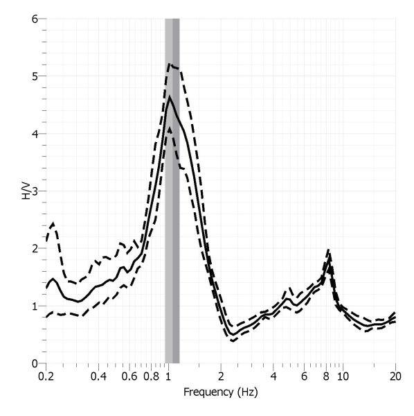
H/V Spectral ratio of seismic noise records from La Seu d'Urgell seismic station.
S-wave velocity model obtained with the array technique
In the shear wave propagation velocity model (Vs) obtained using the array technique, a surface layer with a velocity of about 250 m/s and a thickness of about 10 meters is observed. Below this layer, the velocity increases to 440 m/s and extends to a depth of 60 meters. Then, a layer with a velocity of about 700 m/s is observed that extends to more than 155 meters deep. Finally, the bedrock is detected with a speed of about 2100 m/s.
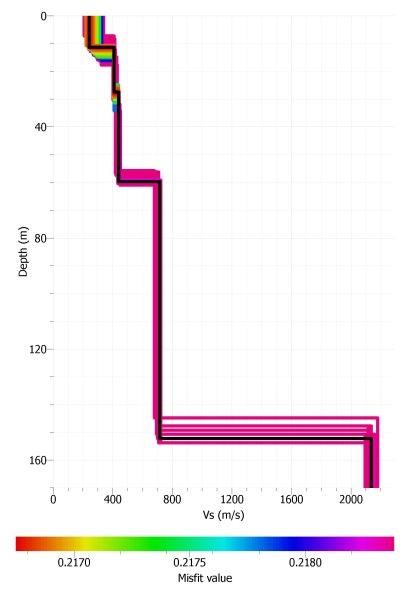
S-wave velocity model of La Seu d'Urgell seismic station.