


Coastal geomorphology
Coastal geomorphology with the classification of typology and its units, dune surface cartography and the characterization of coastal sediments
The Coastal Geomorphology Viewer displays three sets of information: geomorphological classification (coastal typology and coastal geomorphological units), dune systems (2015 dune cartography and historical dunes) and coastal sediment characterization.
The viewer is part of the Coastal Dynamics Information Service (SIDL) project, promoted by the Department of Climate Action, Food and Rural Agenda and funded by the Climate Fund, with the supervision of the Interdepartmental Climate Change Commission and with the technical assistance of the Climate Fund Commission.
The objective of the viewer is to provide a tool to support territorial, urban, road and infrastructure planning in general. This tool should allow administrations, companies and individuals to have a global and integrated vision of the territory with regard to the geomorphology of the Catalan coastline.
Viewer
Description
The viewer displays 3 sets of information that are briefly described below.
Geomorphological classification
This set of information includes two data layers:
Coastal typology
The coastline strip is shown segmented according to 6 coastal typologies:
")
Rocky and abrupt. Formed by a rugged and irregular rocky coast, dominated by cliffs, and with numerous inlets and outlets with small beaches and coves.
All those stretches of coast that include cliffs more than 20 meters high are considered within this typology. These types of coast are the most susceptible to slope movements.
")
Low rocky. It is characterized by rock outcrops or cemented sedimentary deposits, very close to or touching the coastline. It has relatively gentle slopes, without major differences in elevation.
It has enclosed beaches that are located in the shelter of rocky inlets, where landslides can occur; or open beaches of variable length that often constitute a narrow strip, and which are very susceptible to the impact of sea storms due to the little space for accommodation they present.
")
Low depositional. This is a type of coast with low relief, formed by numerous alluvial cones and other deposits of flat morphology, which connect to the sea by means of a gentle profile.
The contribution of sediments from streams and torrents, together with the coastal drift, which reworks these sediments, are the determining factors in its morphology and evolution. They are highly susceptible to storms and slope movements are practically non-existent.
")
Progradant delta. La Their formation is the result of the interaction of fluvial and coastal dynamics. In progradant deltas, the fluvial factor predominates over the marine, so that the sediment brought by the rivers advances towards the sea, giving rise to arched sedimentary outcrops on the coastline. They have beaches along the entire length of the coast.
As they are very flat areas, they are highly susceptible to maritime storms, both due to marine invasion and coastal erosion. Anthropic activities, not only in the coastal strip, but also in the river courses that form the deltas, have modified their natural dynamics.
")
From coastal alluvial plain. This is a type of coast with a very flat or depressed relief, located at the end of a river, where a plain is formed filled by the accumulations of alluvial sediments brought by the river.
These are areas where the fluvial flood plains converge with the coastal dynamics, creating a bay environment, where there are also lagoons, wetlands and deposits of old fluvial channels that have migrated over time. They have beaches along the entire coast and are highly susceptible to maritime storms.

Anthropogenically modified. The general appearance of the coast does not correspond to or is very different from the natural one due to anthropogenic modifications. The original longitudinal profile has undergone significant variations, which can be observed by comparing recent orthoimages with older ones. This includes the coastal frontage of large population centers, all ports and other areas that have been altered by anthropogenic infrastructure.
This is a type of rigid coast where damage to infrastructure or accumulation of sediments can occur during sea storms.
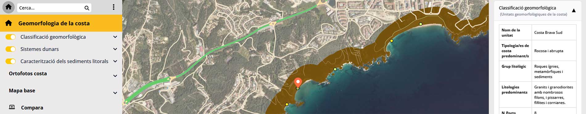
Coastal geomorphological units
The layer shows the division of the coast into 20 units, which share similar characteristics in terms of: coastal typology, geomorphological landscape characteristics, geographical location, lithological constitution and geological structure.
To carry out this classification, the Map of the major structural units of Catalonia 1:1,000,000 (ICGC, 2024), the Geological Map of Catalonia 1:250,000 (ICGC, v3., 2024), the Geological Map of Catalonia at a scale of 1:50,000 (ICGC, v3., 2025) and the Classification of the typology of the Catalan coast (ICGC, 2025) have been used as basic documents.
The user obtains, for each unit consulted, the following information:
- Name of the unit.
- Predominant coastal typology/s.
- Lithological group(s) present in the unit.
- Predominant lithologies.
- Number of beaches.
- Number of ports.
- Number of Areas of Geological Interest.
- Code of the Area(s) of Geological Interest.
- Representative image(s).
Dune systems
This set of information includes two data layers:
2015 dune cartography
The layer shows the mapping of dune systems carried out through the photointerpretation of high-resolution orthophotomaps, at a scale of 1:2,500 from the ICGC, during the spring and summer of 2015. For small dunes, use has been made of orthophotoimages at a scale of 1:1,000. In those cases where it has not been possible to determine with certainty the existence of dune formations, several fieldwork campaigns have been carried out during the spring and summer of the 2016-2019 period.
The cartography is displayed using a layer of polygons with a single symbology. For each polygon consulted, the user obtains the municipality in which it is located and the surface area of the polygon in question, in square meters.
Historical dunes
This layer shows the cartography of historical dunes through points where some type of dune morphology was identified during the period from 1890 to 1960. In order to obtain these data, more than 100 collections or archives of historical photographs belonging to 15 public and private institutions were consulted, as well as aerial photographs from photogrammetric flights carried out by the United States Air Force in 1945 and 1956, and the 1920 flight from the Josep Gaspar Serra collection. Cartographic documents (topographic and geological maps) and written historical documents were also consulted.
The presence of dune systems during the study period (1890–1960) was compared with the current presence of dunes. Each point is assigned an attribute according to the type of change observed in this comparison: a) Disappearance, b) Reduction, c) Minor changes. The cartography is displayed through a point layer with three types of symbology, one for each type of change.
Granulometric characterization of low-lying beach sediments
The layer shows the granulometric characterization of coastal sediment samples located in the low-lying beach area, collected on the coastline or in the wave-beating area. The layer includes the position and information of 407 representative samples of the Catalan coastline, sampled during the autumn of 2022.
The geolocated information is displayed using a layer of points symbolized by the D50 value in 6 ranges according to the grain size limits (in mm) characteristic of the UNE-EN ISO 14688-1 standard.
The user obtains, for each point consulted, the following information:
- Sample reference code: unique code identifying the sample.
- D50 (mm): Statistical value representative of the sample referring to the 50th percentile of the cumulative grain size distribution curve.
- Granulometric classification: Qualitative granulometric classification based on the percentages of the different grain size categories, taking into account the granulometric limits of the UNE-EN ISO 14688-1 standard.
- Presence of pebbles in the sampling area: Qualitative estimate, based on the review of the photographs of the sampling point.
- Percentage by weight of gravel-sized grains (%).
- Percentage by weight of sand-sized grains (%).
- Percentage by weight of silt and clay-sized grains (%).