


Beach evolution
Coastline evolution on the beaches of Catalonia
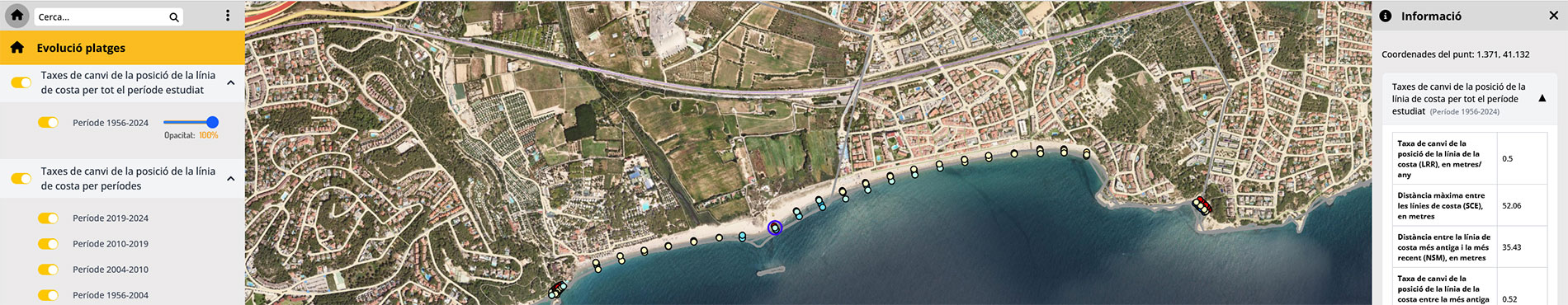
The Beach evolution viewer shows the rates of change in the position of the coastline that implies a change in the width of the beaches. The rates are obtained from the comparison of coastlines for different periods of time.
The viewer is part of the Litoral Dynamics Information Service (SIDL) project, promoted by the Department of Climate Action, Food and Rural Agenda and financed by the Climate Fund, with the supervision of the Interdepartmental Commission on Climate Change and with the technical assistance of the Climate Fund Commission.
The aim of the viewer is to show the evolution of the coastline on the beaches of Catalonia. This detailed knowledge of the position of the coastline in the last 68 years is essential for coastal management. For each queryable point, among other information, the user obtains the rate of change of the position of the coastline in meters/year (if the value is positive, the beach increases and if it is negative, it recedes), the net movement between the oldest and the most modern coastline (it can be a positive value if there is accretion or negative if there is reduction and negative if there is regression) closest (in absolute value because it indicates the magnitude of the change in the period studied).
Viewer
Description
The data shown in the viewer have been obtained from the analysis of the cartography of several coastlines from aerial images. The coastlines are analyzed using the ESRI ArcGIS software with the Digital Shoreline Analysis System-DSAS module. This system allows the calculation of statistics on the rate of change of the lines from multiple historical positions of the coastline in certain transects perpendicular to these traces.
The values obtained from the rate of change of the beach width are represented by colored circles located on the most recent coastline of the study period. The color of each circle indicates the range of the rate according to the common legend for all periods. This allows the rapid identification of areas with retreat or accumulation along the beaches of Catalonia.
The following statistical values of coastline evolution were obtained using the DSAS software:
- Net movement between the oldest and most recent coastline (Net Coastline Movement, NSM), in meters: measures the distance between the oldest and most recent coastline of the period studied. It can be a positive value if there is accretion or negative if there is regression.
- Shoreline Change Envelope (SCE), in meters: measures the distance between the furthest and closest coastline taking into account all available positions. In the case of considering only two coastlines, it coincides with the absolute value of the NSM and is always positive values because it expresses the change, not the direction of movement.
- Rate of change of the position of the coastline between the oldest and most recent (Net Movement Rate, EPR), in meters/year: is obtained by dividing the distance between the oldest and most recent coastline by the time elapsed between the positions. If the value is positive, it indicates accretion, and if it is negative, it indicates coastline regression.
- Rate of change of coastline position (Linear Regression Rate, LRR), in meters/year: Calculates the rate of change by fitting a linear least squares regression to all coastlines and filtering out short-term oscillations. When the value is positive, it indicates an accretion process, while if it is negative, it reflects coastline regression.
To study the period between 1956 and 2024, the values of NSM, SCE, EPR and LRR have been obtained from the following 15 coastlines:
- Orthophoto 1956.
- Orthophoto 2004.
- Orthophoto 2010.
- October-November 2015.
- January-February 2016.
- Temporary January 2017.
- February-March 2017.
- February 2019.
- Orthophoto 2019.
- Temporary Gloria-January 2020.
- May 2020.
- January 2022.
- December 2022-January 2023.
- November 2023-December 2023.
- March 2024.
For the period between 1956 and 2004 2 coastlines were used and the values of NSM, SCE and EPR were obtained:
- Orthophoto 1956.
- Orthophoto 2004.
For the period between 2004 and 2010 2 coastlines were used and the values of NSM, SCE and EPR were obtained:
- Orthophoto 2004.
- Orthophoto 2010.
For the period between 2010 and 2019 7 coastlines were used and the values of NSM, SCE, EPR and LRR were obtained:
- Orthophoto 2010.
- October-November 2015.
- January-February 2016.
- Temporary January 2017.
- February-March 2017.
- February 2019.
- Orthophoto 2019.
For the period between 2019 and 2024, 7 coastlines have been used and the values of NSM, SCE, EPR and LRR have been obtained:
- Orthophoto 2019.
- Temporal Gloria-January 2020.
- May 2020.
- January 2022.
- December 2022-January 2023.
- November 2023-December 2023.
- March 2024.