


2025 Report: VISSIR 4, urban digital twins, SIDL and strengthening natural risk monitoring, as main milestones
From the IICGC, we have published our 2025 Annual Report, which summarizes the main projects developed throughout the year in the fields of cartography, geodesy, geology, and natural hazard management. The publication is structured around four main areas of activity, aligned with the Institute's Program Contract.
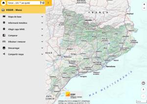
Main interface of VISSIR 4 of the ICGC, with the side menu of tools open and the map of Catalonia in the viewer.
In the area of geoinformation governance, the main goal has been the launch of the new VISSIR 4, the corporate viewer that centralizes access to official geoinformation and incorporates new functionalities, such as the new territorial API and the geocoder for addresses, place names, and parcels.
Regarding territorial geoinformation, at the ICGC we have continued to promote Territorial and urban digital twins, integrating the local topographic reference, urban orthophotos, and the 3D Carrers program to provide municipalities with new tools for territorial planning and management.
In the area of prevention and response to natural hazards, noteworthy developments include enhanced monitoring and advisory services during ground movement events, as well as the commissioning of a new station in the Catalan Seismic Network, which improves the region's observation capabilities.
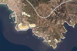
Coastal hazard viewer, with the representation of the danger zones on the coast of Cap de Creus.
In the area of knowledge and support for sustainable land management, the Coastal Dynamics Information Service (SIDL) has continued to incorporate new topographic and bathymetric data of the Catalan coast to support planning and adaptation to climate change.
In parallel, the Institute has continued its collaboration with the Catalan Energy Institute (ICAEN) on the development of the PLATER (Territorial Energy Plan) and the Catalonia Geoenergy Strategy 2030.
The Annual Report also includes the main advances in research and innovation, the activities related to the dissemination and preservation of cartographic and scientific heritage, the activities of the Map Library of Catalonia and the Institute's main indicators for 2025.
The 2025 Annual Report also includes appendices detailing the projects, agreements and contracts, the activities of the coordinating bodies, and other actions carried out during the year.