


Course on Soil mapping and soil assessment for sustainable land management
Soil mapping brings together the set of methods developed to study, classify, and represent the spatial distribution of different soils and their properties within the landscape. This process integrates fieldwork and soil sampling with different sources of spatial information, such as digital terrain models, to process and analyse spatial data. The resulting soil maps provide the most comprehensive and reliable description of the various soil types in a specific area, including their morphological characteristics and physicochemical properties. This information is essential for agriculture, sustainable land management, and land planning, as it enables the assessment of soil suitability for different uses, supports decision-making, and promotes the rational use of this natural resource.
In recent decades, Digital Soil Mapping (DSM) has incorporated new methodologies that combine point-source soil data with environmental covariates, geographic information systems (GIS), remote sensing, geostatistics and machine learning techniques. These approaches allow for the expansion of the spatial coverage of edaphic information and generate continuous predictions of soil properties, which are particularly useful at regional scales. However, DSM does not replace traditional detailed soil mapping but rather complements it. Maps based on fieldwork provide deeper detail and context that computer models can't capture on their own. The integration of both approaches is key to addressing the current challenges of soil mapping, soil conservation, responsible land management, and the growing demand for soil data.
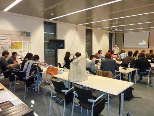
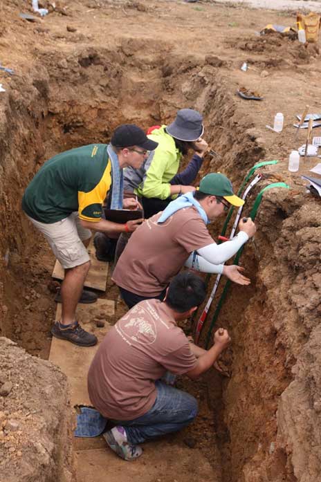
Therefore, the University of Lleida (UdL) and the Cartographic and Geological Institute of Catalonia (ICGC) are launching, dins del micro-credentials programme, an eminently practical course on soil mapping. It will combine theoretical and practical sessions with intensive fieldwork. The field trips and activities will follow the steps for creating a soil map: from gathering available information and establishing soil-landscape relationships to differentiating soil types and generating all data layers within a GIS. The course is strongly career-oriented and will be assessed through a group project consisting of the creation of a soil map for a specific area in the Tremp Basin, where the training takes place. Additionally, students will visit the Cerdanya region (the choice of field trip destination will be subject to weather conditions) to observe soils under various temperature and moisture regimes and explore Catalonia’s soil diversity. The course also includes a visit to the soil monolith collection at the ICGC Pyrenees Territorial Centre.
The course is aimed at graduates (BSc, MSc) in agricultural or earth sciences—such as environmental sciences, physical geography, biology, geology, or agricultural, forestry, and geological engineering—as well as those with international qualifications providing basic soil science knowledge. These qualifications will not require any additional preparatory training.

Course description and main goal
This training offers up-to-date specialisation to address emerging environmental and land planning challenges, qualifying students with the most advanced methodologies in soil mapping. Consequently, the primary objective is to train professionals capable of producing soil studies and soil maps oriented towards sustainable land management.
Career prospects
 Trained professionals will be able to:
- Understand soil distribution across the landscape and provide technical consultancy.
- Produce soil maps for the 1:25000 Soil Map of Catalonia Project and other mapping projects.
- Use and apply digital soil mapping (DSM) techniques.
- Conduct soil studies for land-use planning evaluations (laws relating to agriculture, renewable energy implementation, land consolidation, irrigation schemes, etc.).
- Describe and analyse soil profiles, assessing their potential for providing ecosystem services.
Competences and learning outcomes
 By the end of the course, students will be able to:
- Develop a deep understanding of soil as a resource and recognise different soil types.
- Describe the morphological characteristics of soils.
- Understand soil-landscape relationships and the factors and processes involved in soil formation.
- Understand and correctly apply the key field tests and techniques for soil analysis.
- Identify soil mapping methodologies and to use GIS and soil databases.
- Comprehend the principles of Digital Soil Mapping, including its applications and limitations.
- Apply digital soil mapping tools and effectively communicate the uncertainty of the results.
- Know the fundamentals of soil assessment within the current legislative framework.
- Interpret soil information to infer soil properties and limitations.
- Identify soil formation processes in situ and identify their evidence within the landscape.
- Classify soils according to various taxonomic systems.
- Analyse digital terrain models to produce preliminary soil maps.
- Plan and execute field campaigns (boreholes, observations, and profile descriptions)
- Sample and document soil profiles, including photographic records.
- Organise and analyse field and office-based information to define cartographic units.
Programme structure
The programme of the course consists of five theoretical-practical modules, fieldwork, and a final group project.
- Module 1: Fundamentals of Soil Science and Soil Health.
Basic knowledge of soils, their physicochemical characteristics, and field methodologies (predominantly online). - Module 2: Soil genesis and Soil formation factors.
The soil-landscape model; formation factors and processes to understand the spatial distribution of soils (predominantly online). - Module 3: Soil Classification.
Soil taxonomy and classification systems applied to soil mapping. - Module 4: Soil Mapping (Core Module).
Traditional and digital soil mapping methodologies. Includes GIS, databases, computer-based practicals, field trips, and case studies. - Module 5: Soil Assessment.
Soil assessment systems based on characteristics and limitations, specifically for agricultural uses. Application within the legislative and land-use planning framework.
Course assessment
Course assessment is based on a group project, which will consist of the production of a soil map.
Programme format and calendar

The course follows a hybrid format, combining online teaching with in-person sessions at the ICGC headquarters in Tremp (Catalonia).
- Online phase: 7th and 8th April.
Modules 1 and 2 will be delivered primarily in a virtual format with live teaching (synchronous sessions). - In-person phase: From the 9th to the 10th of April, from the 13th to 17th of April, and from the 20th to the 24th of April, at the ICGC headquarters (Tremp). This phase of the course can be divided in three parts:
- Classes: classroom-based lessons, computer-based lessons for the GIS practicals, and fieldwork (9th and 10th of April and from the 13th to the 17th of April).
- Optional field trip: 18th of April.
- Completion of the course project: from the 20th to the 24th of April. During this week working groups will independently complete the course project with support from teaching staff.
Course information
Languages
Spanish and English.
Course coordinator
Rosa M. Poch Claret (Department of Chemistry, Physics, Environmental and Soil Sciences, UdL).
Teaching team
Jaume Boixadera, Rosa M. Poch, Josep Carles Balasch, Philippe Lagacherie, Joaquín Cámara, Irene Ortiz, Antoni Baltiérrez, Marc Vicens, Jose Ramón Olarieta, Andrea Vidal, Judit Vallverdú and Joan Xavier Gràcia.
Course duration
100 hours, 10 ECTS.
Location
Pyrenees Territorial Support Center (CSTP), ICGC, Tremp,(Catalonia).
See the map
Price
- 195 € for students aged between 25 and 64 through the Micro-credentials plan.
- 650 € for other students.
Places
25 places.
Applications and enrolment
From 29-10-2025 to 07-04-2026 (on the course website).
This is a Project in collaboration with the UdL’s Centre de Formació Permanent, within the Microcreds.cat framework.