Soil Concept
Upper layer of the Earth's crust composed of a mixture of mineral particles, organic matter, water, air and living organisms
The concept of soil has different meanings depending on the field of action of the person defining it. The perception of soil is very different for a farmer, a real estate developer, a scientist, an engineer, a planner or a politician; it is conditioned by how they use it or would like to use it and by the consequences of all this in a global context.
The European Commission has defined soil as the upper layer of the earth's crust that is composed of a mixture of mineral particles, organic matter, water, air and living organisms; which makes up a very complex and variable environment (Figure 1).

Figure 1. A soil in the Alt Urgell region
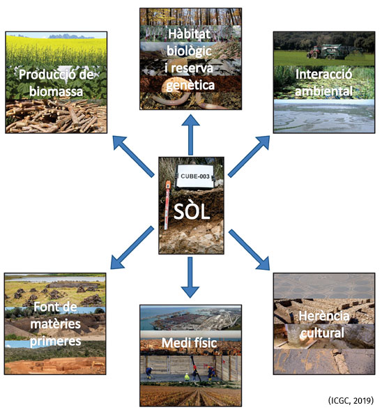
This mixture, located at the lithosphere - hydrosphere - atmosphere interface, constitutes a living, dynamic, non-renewable natural body in the short and medium term, and which fulfills a series of functions (Figure 2) that are usually divided into two large groups:
- Ecological functions, such as:
- Biomass production, the soil facilitates the anchoring of plants and actively participates in the water and nutrient cycles.
- Environmental interaction, the soil stores, filters and transforms matter and energy that regulates the reactions that they have within it, thus protecting the environment from pollution.
- Biological habitat and genetic reserve of germplasm of flora and fauna, acting as a means for the preservation of life on earth.
- Functions linked to human activity, such as:
- Physical environment, where a large part of socioeconomic activities take place (housing, industry, transport, recreational activities, etc.).
- Source of raw materials (clays, sand, gravel...).
- Cultural heritage, which contains important paleontological and archaeological remains to learn about the history of humanity.

Figure 2. Functions of the soil (Bloom, 1988)
Changes in land use have been occurring since man changed his nomadic lifestyle for a sedentary one. Initially, these changes were almost exclusively agricultural and livestock. With the passage of time and the increase in population density, however, other uses such as residential, industrial, transport and communication infrastructures... began to prevail.
In this way, soil is increasingly understood as a limited and vulnerable resource, like water or air, which is subject to numerous and well-documented threats (Figure 3): sealing, pollution, erosion, compaction, loss of organic matter, salinization, etc. On a global scale, the growing pressure that man is exerting on this resource is causing its degradation to accelerate and severely degraded areas to increase day by day, with negative consequences for human health, natural ecosystems, climate change and, ultimately, for our economy.

Figure 3. Some of the threats to which the soil is exposed (sealing, pollution, erosion and salinization)
The establishment of a sustainable and efficient use of land requires the definition, clearly and unambiguously, of the potentials and limitations of soils in relation to the different uses that can be presented. One of the most important challenges that our society faces today is the reconciliation of the demand for the soil resource with its regenerative capacity under natural conditions; given that, when soils are forced beyond their resilience limits, they are not capable of returning to their primitive state of functionality without the massive application of external contributions.
Although a good job has been done in characterizing these problems, it has probably not yet been possible to convey to society the clear message it deserves. For this reason, it is important that the European Commission has approved a Thematic Strategy for Soil Protection (COM(2006)231) and adopted the Directive (COM(2006)232) establishing a framework for the protection of soil in the European Union.
In this regard, it should be noted that, today, many environmental problems, such as nutrient leaching into the sea or soil pollution, cross political borders. The data that must be used to solve this type of problem involve the combination of information from different countries, with the difficulties associated with the geometric and thematic inconsistencies that arise due to the different understanding and interpretation between the mapping systems used. The only solution, in these cases, is the standardization and harmonization of existing data. In this sense, the specifications for soil data currently being developed by the soil working group of the INSPIRE Directive (Infrastructure for Spatial Information in Europe) (Directive 2007/2/EC) seek to resolve or, at least, alleviate these problems.