Classification of structures (buildings) according to their vulnerability.

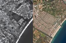
Before and after urbanization (Empuriabrava, Alt Empordà)

High vulnerability to the coastline (Costa Brava)

View of Empuriabrava with the Ull del Temps

Aquifer system of the Port del Comte Massif. a) Conceptual model of the hydrogeological functioning of the Port del Comte massif where the water divides and main flow lines are interpreted as well as the extension of the groundwater reservoirs associated with the different karst springs of the aquifer (Herms, 2022). b) Volumes of the groundwater reservoirs obtained from the updated 3D model (v1.0, December 2024).

Reconstruction of the 3D aquifer model: a) structural and lithostratigraphic surfaces; b) volume of the lower Eocene karst aquifer.
![Delimitation of forest fires and evolution (Pont de Vilomara Fire) [MENUT B7.B3.B2 –IRC] Delimitation of forest fires and evolution (Pont de Vilomara Fire) [MENUT B7.B3.B2 –IRC]](https://icgc-web-pro.s3.eu-central-1.amazonaws.com/produccio/s3fs-public/styles/media_library/public/2024-12/newspace_ullsicgc_fig01.jpg?itok=eRqhP3E-)
Delimitation of forest fires and evolution (Pont de Vilomara Fire, July 2022)
[MENUT B7.B3.B2 –IRC]