
 Contact


It is during the Pleistocene when the Iberian Peninsula acquired the rest of the geographical features that give it the aspect we know today. From the point of view of geodynamics, from the late Pliocene, some 2 Ma ago, a period of relative calm started, interrupted now and then by the volcanic eruptions located in the north-east area of Catalonia. But, climatically, it was an epoch of great variability. After a time of benign climate, which was maintained from the late Pliocene until the middle Pleistocene, from some 900 000 years ago, five glaciations took place separated by intervals of warm climate, called interglacials (figure 17).
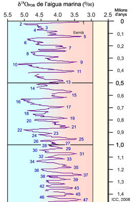
Figure 17: Climatic curves of the last million years (Pleistocene and Holocene); the even numbers indicate each one of the glacial epochs and the odd numbers the interglacial warm periods. Detail of the Geological Time Table.
During the glacial epochs the snowfall exceeded the summer melting, and year after year, great quantities of ice accumulated in the polar icecaps and in the areas with the highest reliefs (figure 18). While the glacial conditions were maintained, the volume of water in the form of ice trapped in the polar ice caps caused the sea level to descend dozens of metres below the actual level. Consequently, the water courses were strongly incised in the relief and deposited, in their estuaries, gravels and sands in the form of coastal and delta fans. In the highest areas of the Pyrenees cirques and valley glaciers were formed, which accumulated and transported boulders and fragments of rock to its moraine at the same time as they eroded their beds, giving them the typical U-shaped valleys of glacial origin. In the areas with steep slopes near the glaciers, areas known as periglacials, the repetitive freeze-melt process of the interstitial rock water and the water retained in cracks and joints provoked mechanical fragmentation and the consequent accumulation of the boulders and pebbles at the foot of the slopes in the form of typical talus scree.
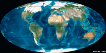
Figure 18: The configuration of the Earth during the Pleistocene glacial epochs, with extensive polar icecaps
During the interglacial epochs, a large part of the ice of the polar icecaps was melted, the level of the sea rose and the water courses deposited the sediments that they transported in the banks of their beds. Far from the glacial areas, those climatic changes were reflected in the formation of soil and carbonated crusts over the alluvial sediments and in the periodic accumulation of fine-grained sediments such as loess, which were transported by the wind in the form of dust clouds.
In the zones with extensive outcrops of calcareous rocks, of conglomerates with pebbles and carbonate cement or other rocks soluble in water or in carbonic acid, karstification processes were developed that gave place to systems of caverns, chasms and dolines. Some of those dolines evolved to true lacustrine areas. The waters saturated with calcium carbonate settled at the exits of the karst systems and, in some cases, continue to settle at the present time, some precipitates and carbonatic incrustations: the travertines. The changes of the base level, together with the combined action of chemical dissolution and mechanical abrasion, provoked that, on crossing areas composed of carbonates, the fluvial courses formed narrow and deep gorges.
Thus, during the Pleistocene, the incision of the drainage network continued to generate potential gaps that had a tendency to fill. The reiteration over time of all the mentioned processes, lead to the formation of stepped terraces and alluvial fans, to the gorges formation, to the formation of marine abrasive platforms, to the establishment of the fluvial network almost as we know it nowadays and, finally, to the definition of the basic features of the present sculpture of the landscape.
