


SPIRAL inventory
Inventory of slope movements in the Pyrenees
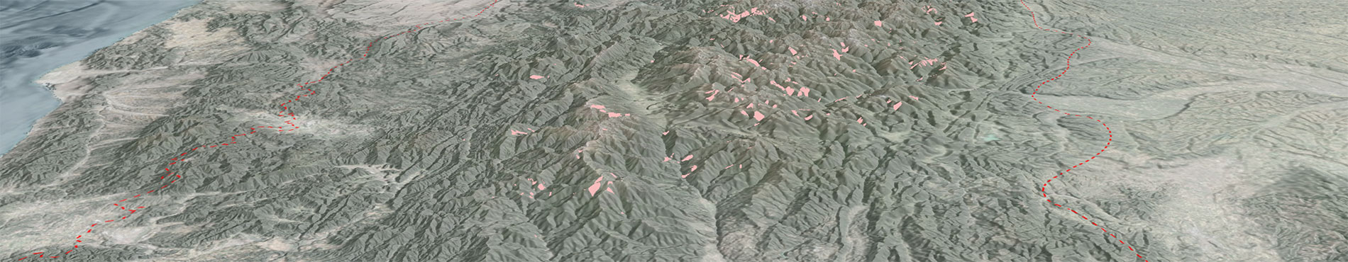
The SPIRAL Viewer is a tool developed within the framework of the European SPIRAL project (Pyrenean Landslide Warning Strategy) [Interreg POCTEFA 2021-2027, EFA039/01], It provides the public with a harmonized inventory of slope movements covering the entire Pyrenean massif, including territories in France, Spain, and Andorra.
The inventory covers 25,000 km² and contains more than 20,000 phenomena (including over 1,600 large landslides). It integrates data from various institutional and academic sources. The primary data sources correspond to the project partners’ databases: ICGC, Bureau de Recherches Géologiques et Minières (BRGM), Centre for Studies and Expertise on Risks, Environment, Mobility and Urban Planning (CEREMA), University of Zaragoza (UNIZAR), and Andorra Research and Innovation (AR+I), as well as new events mapped within the framework of the project.
The inventory also incorporates data provided by the University of the Basque Country, the Government of Navarre, and information from publicly available online sources, such as the BDMoves database of the Geological and Mining Institute of Spain (IGME), BDORPHAN, or BDRM from the National Forest Office – Mountain Area Restoration (ONF-RTM). In addition, it includes new mapping obtained through photointerpretation and fieldwork, as well as information from the radar interferometry service of the European Ground Motion Service (EGMS), grouped into Active Deformation Areas (ADA).
Finally, it compiles bibliographic references to scientific articles, technical reports, and news documenting significant events in the Pyrenees.
Description
The SPIRAL inventory data model was designed to consistently record slope movements across the Pyrenean region. Three requirements were established, 1) to facilitate data entry, 2) to highlight essential characteristics for risk management (including consequences), and 3) to maintain academic rigor in classification. The objective is to provide a practical tool for technicians, administrations, and specialists to analyse the spatial and temporal distribution of phenomena and assess their impact.
For the classification of phenomena, a dual strategy was established: an initial simplified classification based on the most common geological processes generating ground deformation in the mountain range, and a second “complete” classification based on the Varnes classification (Hungr et al., 2014).
The simplified classification consists of 4 categories that are briefly explained in the following sections:
Rockfalls

Slope movements occurring on steep slopes along a surface where the mobilized mass undergoes mainly aerial movement, with limited contact with the ground surface, typically experiencing fragmentation or disintegration during its trajectory.
On cliffs, movement generally occurs by free fall, which upon impacting gentler slopes continues by bouncing and eventually rolling.
These are very rapid, spontaneous, and sudden movements with high mobility, as their propagation paths usually extend much farther than the initial failure point.
Landslides

Movement of a mass of soil or rock along a sliding surface, where intense shear deformation controls the movement. The rupture surface may take various forms, most commonly circular or planar, leading to rotational, translational, and/or complex movements.
In general, landslides involve the movement of a mass in continuous contact with the underlying ground, and the displaced material largely retains its original internal structure. Deformation is concentrated along rupture surfaces.
The mobility of landslides varies greatly depending on their nature and size relative to the slope, but typically a large portion of the displaced mass remains near the initial rupture area. Their velocity is also highly variable, ranging from very rapid, sudden events to slow and progressive movements.
Debris flows (torrential flows)
")
Ground movements in which the mass becomes fluidized, losing its original internal structure and acquiring a viscous behaviour that enables it to travel beyond the initiation area. Flows consist of mixtures of solid particles and water in widely varying proportions and compositions.
Particle size varies, and together with the solid/liquid ratio, determines the flow’s dynamic behaviour (Pierson and Costa, 1987).
Debris flows are very rapid and highly mobile, often traveling far beyond their origin.
Deep-seated slope deformations

Movements affecting an entire slope or a large portion of it. They may or may not have a clearly defined rupture surface, which is typically deep in the central part of the movement. The nature of the mobilized material depends on the slope typologies but generally includes both surface soil and underlying bedrock, often involving multiple material types described by Cruden and Varnes (1996).
The displaced mass largely loses its internal structure, although large blocks may still preserve it.
This category includes phenomena such as rockslides, debris avalanches, rock avalanches, lateral spreads, and deep-seated gravitational slope deformations (DSGSD).

Data source of the SPIRAL inventory: AR+I, Andorra Research and Innovation; BRGM, Office of Geological and Mining Research (France); ICGC; IGME, Geological and Mining Institute of Spain; UNIZAR, University of Zaragoza; UPV, University of the Basque Country.
References
- Ayala, J.L. (2010). Detecció i recuperació de riscos naturals a través de les fonts documentals andorranes. Ajut de recerca històrica Cebrià Baraut 20082009, Govern d’Andorra.
- Barra, A., Crosetto, M., Luzi, G., Palamá, R. (2021). Mapas de deformación, series temporales de deformación, asentamientos diferenciales a alta resolución. Proyecto MOMPA. E3.2.1.
- Bornaetxea, T., Remondo, J., Bonachea, J. et al. (2023) .Exploring available landslide inventories for susceptibility analysis in Gipuzkoa province (Spain). Nat Hazards, 118: 2513–2542. https://doi.org/10.1007/s1106902306103w.
- Boudou, M. (2015). Monographie des inondations d’octobre 1940 dans les PyrénéesOrientales. Extrait du tome 2 (Annexes) de la thèse de: M. Boudou, Approche multidisciplinaires pour la caractérisation d’inondations remarquables, thèse de Géographie et Aménagement de l’Espace, Université PaulValéry Montpellier III, 462 p. (+344 p. Annexes).
- Buxó, P. (coord.) (2022). Els episodis regionals d’esllavissades als Pirineus, Monografia tècnica, 10, 122 p. Institut Cartogràfic i Geològic de Catalunya, Generalitat de Catalunya.
- BRGM. Base de données de mouvements de terrain. Bureau de Recherches Géologiques et Minières. https://www.georisques.gouv.fr/risques/mouvements-de-terrain/donnees#/.
- Cerema (2018). Les Glissements Orphelins – Identification et Méthodologie d’étude. Rapport d’étude. Version V1.2 du 20180205.
- Colas, B. (2013). Cartographie de l’aléa mouvement de terrain du département des Pyrénées Orientales Echelle 1:50.000 Rapport final BRGM/RP62991FR Décembre 2013.
- Colas, B., Thiery, Y., Bernardie, S., Moya, J., Marturià, J., Sastre, V., Fabregat, I., Buxó, P., Premaillon, M., Guitet, J., Levy, C., Mashhoud, H., Courbier, P., Bouroullec, I. (2022). Projet PYRMOVE. Action 4 / Prévision et gestion de grands mouvements de terrain affectant des infrastructures. Action 5 / Prévision et gestion de crise liée à des mouvements de terrain multiples pendant des épisodes pluvieux (MORLEs). Rapport final V1, 31/08/2022. BRGM/RP72570FR, 18p. 5 annexes.
- Cruden, D. M., Varnes, D. J. (1996). Landslide Types and Processes, Special Report, Transportation Research Board, National Academy of Sciences, Special Report 247, 3675.
- Desfarge, J. Ph., Lande, M. (1984). Mouvements de terrain et mutations economiques recentes en Andorre a la suite des inondations de noviembre 1982.
- Guerrero, J., Gutiérrez, F., Carbonel, D., Bonachea, J., García Ruiz, J. M., Galve, J. P., Lucha, P. (2012). 1:5000 Landslide map of the upper Gállego Valley (central Spanish Pyrenees). Journal of Maps, 8 (4): 484–491. https://doi.org/10.1080/17445647.2012.751345.
- Guerrero, J., Gutiérrez, F., García Ruiz, J.M. et al. (2018). Landslidedam paleolakes in the Central Pyrenees, Upper Gállego River Valley, NE Spain: timing and relationship with deglaciation. Landslides, 15: 1975–1989. https://doi.org/10.1007/s1034601810189m.
- Hungr, O., Leroueil, S., Picarelli, L. (2014). The Varnes classification of landslide types, an update. Landslides, 11: 167–194.
- IGC (2013). Informe preliminar dels efectes dels aiguats i riuada del 18 de juny de 2013 a la conca de la Garona. Informes tècnics de l'Institut Cartogràfic i Geològic de Catalunya, AP-049/13, 97 p. Generalitat de Catalunya.
- ICGC (2020a). Identificació, validació i valoració de fenòmens d’esllavissades d’ocurrència múltiple a Catalunya (MORLE’s). Informes tècnics de l'Institut Cartogràfic i Geològic de Catalunya, AP-0094/20, 94 p. Generalitat de Catalunya.
- ICGC (2020b). El temporal Gloria (1923/01/2020). Els efectes dels processos geològics sobre el territori. Monografia tècnica, 8, 125 p. Institut Cartogràfic i Geològic de Catalunya, Generalitat de Catalunya.
- ICGC (2024). Guia per l’elaboració d’Estudis d’Identificació de Riscos Geològics per a urbanisme (EIRG). Monografia tècnica, 17, 84 p. Institut Cartogràfic i Geològic de Catalunya, Generalitat de Catalunya.
- ICGC (2025). Base de dades d’esllavissades (LLISCAT). Universitat Politècnica de Catalunya, Institut d'Estudis Catalans i Institut Cartogràfic i Geològic de Catalunya. https://www.icgc.cat/lliscat.
- IGME (2016). Base de Datos de Movimientos del terreno (BDMOVES). Consejo Superior de Investigaciones Científicas - Instituto Geológico y Minero de España. https://info.igme.es/BDMoves/.
- Jarman, D., Calvet, M., Corominas, J., Delmas, M., Gunnell, Y. (2014). Large‐scale rock slope failures in the eastern Pyrenees: identifying a sparse but significant population in paraglacial and parafluvial contexts. Geografiska Annaler: Series A, Physical Geography, 96 (3): 357–391. https://doi.org/10.1111/geoa.12060.
- Marturià, J. et al (2022). Análisis del riesgo por movimientos del terreno en el Pirineo Oriental con interferometría radar. X Simposio Nacional sobre Taludes y Laderas Inestables. Granada, septiembre 2022.
- Moya, J. (2002). Determinación de la edad y de la periodicidad de los deslizamientos en el Prepirineo oriental. Tesis doctoral, UPC, Departament d’Enginyeria del Terreny, Cartogràfica i Geofísica. Barcelona.
- ONFRTM. Base de données des mouvements de terrain dans les Pyrénées et Alpes françaises. https://geo-onf.opendata.arcgis.com/maps/0110b72f9a9b486da24ab21cba6322d1/explore?location=42.802359%2C1.248492%2C9.
- Pierson, T.C., Costa, J.E. (1987). A rheological classification of subaerial sedimentwater flows. In Costa; Wieczorek (eds.): Debris Flows/Avalanches: Process, Recognition, and Mitigation. Rev. Eng. Geol., Geol. Soc. Am., Boulder, Co., 7: 112.
- Portilla Gamboa, M. E. (2014). Reconstrucción y análisis de ocurrencias regionales de múltiples eventos de movimientos en masa generados por lluvias históricas en los Pirineos. Tesis doctoral. UPC, Departament d’Enginyeria del Terreny, Cartogràfica i Geofísica. Barcelona.
- Varnes, D. J. (1984). Landslide hazard zonation: a review of principles and practice. IAEG Commission on Landslides and other Mass Movements. UNESCO Press, 63 p. Paris.