


Elevation models
High‑resolution elevation models of Catalonia
The ICGC offers high-precision elevation models covering the territorial area of Catalonia. Specifically, it provides Digital Terrain Models (DTM) with a resolution of up to 50 cm for all of Catalonia and 25 cm resolution for the area of the Barcelona Metropolitan Area.
It also offers Digital Surface Models (DSM) with 1 m resolution and full coverage of Catalonia, and 25 cm resolution within the Metropolitan Area.
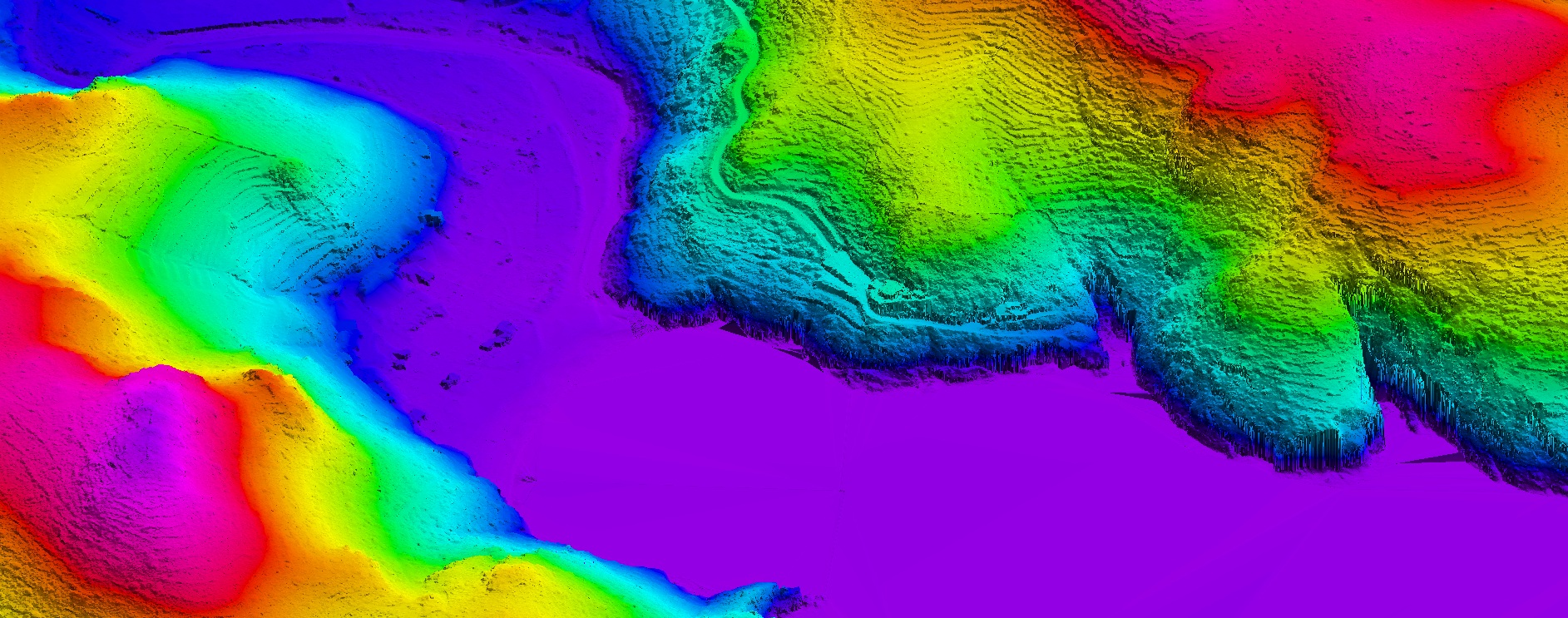
The highest-resolution DTMs are generated from LiDAR flights, which provide a georeferenced and classified point cloud to separate terrain, buildings, vegetation, and water. DTMs are generated from the terrain class and represent the natural topography.
DSMs include all surface elements and are produced through aerial image correlation. Thus, DTMs derived from LiDAR flights have a 4‑year update cycle, while DSMs are updated annually with each new photogrammetric coverage flight.
| Geoinformation from the Cartographic and Geological Institute of Catalonia subject to a Creative Commons Attribution 4.0 International license (CC BY 4.0). More information |
Last update
- Publication date: February 2026.
- Information date:
- DTM: 2008-2023.
- DSM: 2022-2024.
- Version: v1.0.
Description
The ICGC provides high‑precision elevation models covering the entire territory of Catalonia. These products are essential for multiple technical, scientific, and planning applications. Specifically, the ICGC offers DTMs with a resolution of up to 50 cm for all of Catalonia and 25 cm for the Barcelona Metropolitan Area, as well as DSMs with a resolution of 1 m for the whole territory and 25 cm within the metropolitan area.
DTMs represent the natural topography of the terrain, excluding elements such as buildings, vegetation, or infrastructure. The highest‑resolution ones are generated from LiDAR flights, a technology that emits laser pulses from aircraft to obtain a georeferenced and classified point cloud. This classification makes it possible to separate terrain from surface objects, thereby creating a model that reflects only the natural morphology. DTMs are ideal for hydrological studies, analysis of natural hazards (such as floods or landslides), territorial planning, infrastructure design, and 3D landscape modelling.
DSMs, on the other hand, include all visible surface elements: buildings, vegetation, street furniture, etc. They are generated through aerial image correlation, a technique that compares photographs taken from different angles to reconstruct the three‑dimensional geometry of the surface. DSMs are especially useful for urban planning applications, solar shadow simulations, visual impact studies, telecommunications network planning (such as antennas), and projects related to forest management. Regarding updates, DTMs derived from LiDAR flights follow an approximate 4‑year update cycle, while DSMs are updated annually thanks to new photogrammetric flights. This frequency ensures that the models accurately reflect changes in both the territory and urban areas.
In summary, the ICGC elevation models are a key tool for professionals in engineering, urban planning, environmental management, and research, offering reliable and detailed information for decision‑making and project development.
Main technical characteristics
DTM product: Accurate representation of the topography without surface elements.
- Coverage: Catalonia.
- Data source: LiDAR point cloud from the 3rd LiDAR data coverage of Catalonia, years 2021, 2022 and 2023.
- Resolution: 0.5 m pixel in Catalonia‑wide models, 25 cm in the AMB‑area model.
- Reference system: EPSG: 25831.
- Format: GeoTIFF (raster). Null values: ‑9999.
- Update frequency: Every 4 years with each new LiDAR data coverage of Catalonia.
DSM product: Representation of the surface including all visible elements (buildings, vegetation, etc.).
- Coverage: Catalonia.
- Data source: Aerial image correlation from the annual Catalonia coverage flight; LiDAR flight over the AMB in 2022.
- Resolution: 1 m pixel in Catalonia‑wide models, 25 cm in the AMB‑area model.
- Reference system: EPSG: 25831.
- Format: GeoTIFF (raster). Null values: ‑9999.
- Update frequency: Annual in Catalonia‑wide models; on demand for the AMB‑area flight.
Use cases
Hydrological planning and flood‑risk management (DTM)
DTMs with 50 cm resolution provide a highly accurate representation of the natural topography of Catalonia, excluding buildings, vegetation, and other surface elements. This precision is essential for hydrological modelling, as it allows reliable simulation of water behaviour during intense rainfall events, calculation of flows and drainage basins, and identification of potentially flood‑prone areas.
The fact that the DTM covers the entire Catalan territory continuously is a key advantage: it is not a fragmented model but a homogeneous base that facilitates studies at both regional and local scales. This is particularly useful for planning hydraulic infrastructures—such as canals, reservoirs, and drainage systems—as well as for civil protection, which requires reliable information to define emergency protocols and evacuation zones.
Moreover, this information is essential for assessing the impact of climate change on hydrological regimes, anticipating risks in urban and rural areas, and supporting sustainable land‑management policies. The combination of high resolution and wide territorial coverage makes the DTM an indispensable tool for administrations, engineering firms, and agencies responsible for safety and environmental planning.

DTM and orthophoto of the Tiana stream
Visual‑impact studies, urban simulation, and telecommunications planning (DSM)
DSMs are an essential tool to understand and manage both the built and natural environment. The ICGC provides an annual DSM of all Catalonia with 1‑m resolution, ensuring constant updates and a complete view of the territory. This frequency is a key factor for projects requiring recent data, such as urban planning, forest management, or landscape‑change analysis.
In addition, within the Barcelona Metropolitan Area, we provide a DSM with an exceptional resolution of 25 cm, allowing very high‑detail work in densely urbanised environments. This precision is ideal for solar‑shadow simulations, visual‑impact studies, and height planning in new urban developments. It is also especially valuable for telecommunications network planning, as it facilitates line‑of‑sight calculations for antennas, optimisation of mobile‑network coverage, and strategic placement of infrastructure in complex areas. The combination of high resolution and annual updates makes the DSM an essential tool for decision‑making in territorial and urban‑scale projects.

DSM and orthophoto of Collserola
Territorial planning and 3D landscape modelling (DTM + DSM)
The combination of DTM and DSM across large territorial extents is ideal for creating continuous 3D models that represent both natural topography and surface elements. These models are useful for regional‑scale territorial planning, ecological corridor analysis, forest‑management projects, and linear‑infrastructure design such as roads or railways. The 50‑cm and 25‑cm resolutions allow working with a level of detail that greatly supports strategic decision‑making in large‑scale projects.

DTM and DSM of Montjuïc