
 Contact


Digitization and custody of frames for Andorra (2016)
In 2014, the ICGC and the Ministeri d'Ordenament Territorial (MOT) of the Government of Andorra signed an agreement under which the ICGC would digitize and deliver in digital format a series of analogue aerial photograms owned by the Government of Andorra. The ICGC already guarded a part of these photograms and the rest were delivered by the French IGN. The agreement also included the delivery of the digital images owned by the ICGC that covered all or part of the Andorran territory. Finally, the ICGC assumed indefinite custody of all the analog photograms of the MOT. Related to this 2014-2016 project, a total of 3,566 negatives have been digitized and delivered.
Institut Cartogràfic i Geològic de Catalunya (ICGC); Ministeri d’Ordenament Territorial (MOT) (Govern d’Andorra).
Support for the CTBTO (2015)
The ICGC is part of the Preparatory Commission of the CTBTO (Comprehensive Nuclear-Test-Ban Treaty Organization). The CTBTO is an international organization of the United Nations system, headquartered in Vienna, with the goal of putting into operation a global verification regime to monitor compliance with the Treaty consisting, among others, of an international surveillance system, an international data center or the possibility of requesting an inspection on site (On Site Inspections - OSI).
Urban expansion of the European southwest metropolis (EURMET) (2003-2005)
The project seeks, by means of the analysis of SPOT-5 images of 10 European cities (Barcelona among them), to identify the new real perimeters of the urban areas from the organization of the space and of the economic and social contents.
Institut Cartogràfic de Catalunya (ICC); Centre Interdisciplinaire d'Études Urbaines (Université de Toulouse-Le Mirail), France; Centre de Política del Sòl i Valoracions (Universitat Politècnica de Catalunya), Spain; Centro de Estudios de Geografia e Planeamento Regional (Facultade de Ciências Sociais e Humanas, Universidade Nova de Lisbon), Portugal.
Financed by: FEDER funds of the European Union (INTERREG III program).
Detection of lagoons on the plain of Mojos (Bolivia) (1995-1998)
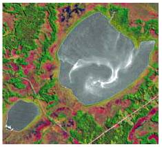
The aim of the project was to search for traces of an unknown Pre-Columbian civilization that appears to have been present in large numbers on the Amazonian slopes of Bolivia. To this end, Thematic Mapper (TM) images from the Landsat-5 satellite were studied, which was shown the existence of a large number of artificial lagoons still there today, together with the remains of many others. It appears that the inhabitants obtained considerable agricultural resources from these lagoons in an environment which, today, is very poor.
Institut Cartogràfic de Catalunya (ICC); Centre d'Estudis Amazònics, Barcelona, Spain.
Financed by: Centre d'Estudis Amazònics; Generalitat de Catalunya, Barcelona, Spain.
