
 Contact


Theoretical course on nivology and avalanches addressed to the Cos de Banders of Andorra (2016)
The ICGC taught a course on nivology and avalanche control for the 2017-2018 season to the Cos de Banders in Andorra, the forestry agents assigned to the Ministeri del Medi Ambient, Agricultura i Sostenibilitat (Govern d'Andorra).
Institut Cartogràfic i Geològic de Catalunya (ICGC); Govern d’Andorra.
Maintenance of meteorological stations of CENMA, Andorra (2016)
In 2016, the ICGC signed an agreement with the Institut d'Estudis Andorrans (IEA) to carry out the ordinary and corrective maintenance of the automatic meteorological stations (EMA) managed by the Centre d'Estudis de la Neu i la Muntanya (CENMA): Aixàs , Bony de les Neres, Perafita, Sorteny and Pic del Maià. Ordinary maintenance is carried out when access is not covered by snow (summer or autumn) and corrective actions are taken when it is required.
Institut Cartogràfic i Geològic de Catalunya (ICGC); Institut d’Estudis Andorrans, Andorra.
Maintenance of the meteorological station of Les Fonts d'Arinsal, Andorra (2016)
The Àrea de Conservació i Explotació de Carreteres (COEX) of the Ministeri d'Ordenament Territorial (MOT) of the Government of Andorra requested the ordinary maintenance of the automatic meteorological station (EMA) located in Les Fonts d'Arinsal, in the parish of La Massana. The works were carried out coordinated with those of the maintenance of the CENMA stations and consisted mainly of checking and reviewing all the elements and sensors.
Institut Cartogràfic i Geològic de Catalunya (ICGC); Govern d'Andorra.
Maintenance of the meteorological stations of FEDA, Andorra (2016)
Ordinary maintenance for a period of three years (2016-2018) of the five meteorological stations (EMA) of Forces Elèctriques d'Andorra (FEDA): Escaldes Central, Engolasters, Ransol, Grau Roig and Margineda. This maintenance service consists, among other things, in the general revision of the structure, the checking and correction, if necessary, of the fixing, leveling, orientation and cleaning of the elements, the change of desiccants, the revision of all connections and wiring, the revision and calibration of the sensors, etc.
Institut Cartogràfic i Geològic de Catalunya (ICGC); Forces Elèctriques d'Andorra (FEDA).
Corrective maintenance of the meteorological stations of Sorteny and Pic del Maià, Andorra (2016)
The Centre d'Estudis de la Neu i la Muntanya (CENMA), of the Institut d'Estudis Andorrans (IEA), asked the ICGC for the corrective maintenance (not foreseen action or repair) of the automatic meteorological stations (EMA) of Sorteny and the Pic del Maià, in the parishes of Ordino and Encamp respectively, in Andorra.
Institut Cartogràfic i Geològic de Catalunya (ICGC); Institut d’Estudis Andorrans, Andorra.
Coordination of the European Avalanche Warning Services (EAWS) (2015)
Participation in the revision of the avalanche danger scale through the extension of the Bavarian matrix that includes the cases of avalanche danger levels. Patterns or situations for avalanches were established, in which four problems for avalanches plus a situation of stability were defined. The definition of these situations should be useful to reach a European consensus on problems derived from common avalanches, but it should also facilitate the user's approach to avalanche predictions through a simplification of danger communication and through the definition of strategies to face these problems. In this sense, a compendium was written that includes the definition of the situation, the fundamental characteristics and the strategy to face it.
Maintenance of meteorological stations of Andorra (2015)
Maintenance of the high mountain automatic meteorological stations of the Servei Meteorològic de Catalunya, of four stations of the Institut d'Estudis Andorrans and five of Forces Elèctriques d'Andorra.
Institut Cartogràfic i Geològic de Catalunya (ICGC); Servei Meteorològic de Catalunya; Institut d’Estudis Andorrans, Andorra; Forces Elèctriques d’Andorra (FEDA).
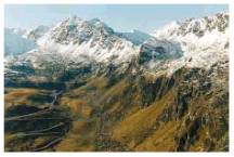
Climate change impacts on snow tourism in the Pyrenees (2011-2012)
Research project involving different regions: Andorra, Aragon and Catalonia. The UPC is the regional coordinator in Catalonia. The IGC collaborates in one of the three working groups, specifically in the physical group. The main goals of this project are to improve knowledge about the effects of climate change, to assess the current socio-economic impact of snow tourism in the Pyrenees and to establish models that link future climate scenarios with the evolution of the technical operability in ski areas. The purposes of the physical group in which the IGC is integrated are: to study the evolution of climate indicators to detect changes in the high mountain climate, to study the variations in the frequency and magnitude of episodes of large avalanches, to model the climate change both at regional and at local level.
Spain: Universitat Politècnica de Catalunya (UPC), Consejo Superior de Investigaciones Científicas (CSIC), Institut Geològic de Catalunya (IGC) and Conselh Generau d'Aran (CGA). Andorra: Centre d'Estudis de la Neu i la Muntanya (CENMA) and Observatori de la Sostenibilitat d'Andorra. France: MétéoFrance.
Financed by: Working Community of the Pyrenees.
Alternative avalanche protections at Rajo Sur mine exploitation in El Teniente, Chile (2008)
Study of alternative avalanche protections in Rajo Abierto, Los Botaderos, Lastre and Los Stocks de Alta y Baja Ley, of the future Rajo Sur exploitation at El Teniente mine, Comuna de Machalí, Chile.
Works to be carried out:
- Cartography at a scale of 1:5 000 of avalanche zones.
- Geomorphological characterization of each zone.
- Topographic profiles to define each avalanche zone.
- Collection of historical data from the existing bibliography and during the field campaign.
- Analysis of available snow and meteorological data.
- Numerical modelling of the avalanche zones in which it is necessary to know in detail the dynamics of the avalanche.
- Proposal of alternatives for avalanche protection, including economic valuation.
Institut Geològic de Catalunya (IGC).
Financed by: Asistencia Profesional en Materias de Montaña LTDA, Chile.
Proposal for the assessment of avalanche risk and technical defences at Mina Veladero, Chile (2007)
The objective of this study is to carry out two tasks:
1) Preparing a cartography of avalanche zones, which consists of locating the path affected by avalanches and mapping in detail 30 routes located within the area considered of high interest, mainly along the 7 km of access to the Veladero Mine.
2) Modelling the behaviour of large avalanches around the 30 routes. For this work it is necessary to characterize the already known avalanches and to determine their main dynamic parameters (speed, pressures, height of the flow ...).
Institut Geològic de Catalunya (IGC).
Financed by: Asistencia Profesional en Materias de Montaña LTDA, Chile.
ALUDEX. Avalanches characterisation, using a dendrochronological and a nivometeorological approach (2002-2005)
The Aludex project aims to use dendrochronology to find out when past avalanches occurred and their return period whenever possible, as well as to gather evidence for the meteorological conditions that cause catastrophic avalanche events in the Pyrenees. The information obtained by this project will contribute to a better understanding of these phenomena and will provide data that can be applied in dynamic avalanche models to determine avalanche hazard and risk.
Institut Cartogràfic de Catalunya (ICC); Universitat de Barcelona (UB).
Financed by: Ministerio de Ciencia y Tenología; FEDER (REN2002-02768).
PARAMOUNT. Public Safety & Commercial Info-Mobility Applications & Services in the Mountains (2002-2003)
The main aim of this project has been to develop a location service for hikers and rescue services in the Alps and the Pyrenees, where two testing areas have been defined. Three types of services were developed: Infotour, to provide the user with a variety of local information and navigation directions; Safetour, to provide information related to mountain safety, and Datatour to involve users in the acquisition and maintenance of the Paramount database. Data are transferred via http protocol using XML.
Institut Cartogràfic de Catalunya (ICC); Gesellschaft für Satellitennavigation, Germany; Universität der Bundeswehr; Germany; Bayerische Bergwacht, Germany; Österreichischer Bergrettungsdienst, Austria.
Financed by: Programme IST of the European Union.
Avalanche prediction in the Pyrenees (2001)
Joint accomplishment of the spreading tasks on avalanche danger for all the Pyrenees, which includes the French, Spanish and Andorran Pyrenees. It was materialized in a publication which includes the telephone numbers of interest for knowing the state of ski tracks and the weather, advice for skiers and the European scale of avalanche risk.
Institut Cartogràfic de Catalunya (ICC); Dirección General del Instituto Nacional de Meteorología (Ministerio de Medio Ambiente), Madrid, Spain; Ministeri de la Presidència i Economia (Departament de Transport i Energia) of the Government of Andorra; Météo-France.
Financed by: Undertaken jointly by the participating institutions.
SAME (1996-1998)

The ICC was responsible for the coordination between the various European cartographic institutions participating in this project. A questionnaire has been drawn up in order to obtain all existing information about avalanches in Europe, so that all the databases and cartography relating to avalanches may then be homogenized.
Institut Cartogràfic de Catalunya (ICC); Centre National du Machinisme Agricole, du Génie Rural, des Eaux et des Forêts (CEMAGREF), Grenoble, France; Technische Universität Graz, Austria; Norges Geotekniske Institutt (NGI), Oslo, Norway; Vedurstofa Íslands, Reykjavík, Iceland; Centro Sperimentale Valanghe e Difesa Idrogeologica of the Regione del Veneto, Italy; Eidgenössische Forschungsanstalt für Wald, Schnee und Landschaft (WSL), Davos, Switzerland.
Financed by: Directorate General XII for Science, Research and Development (Programme: Environment and Climate) of the European Union.
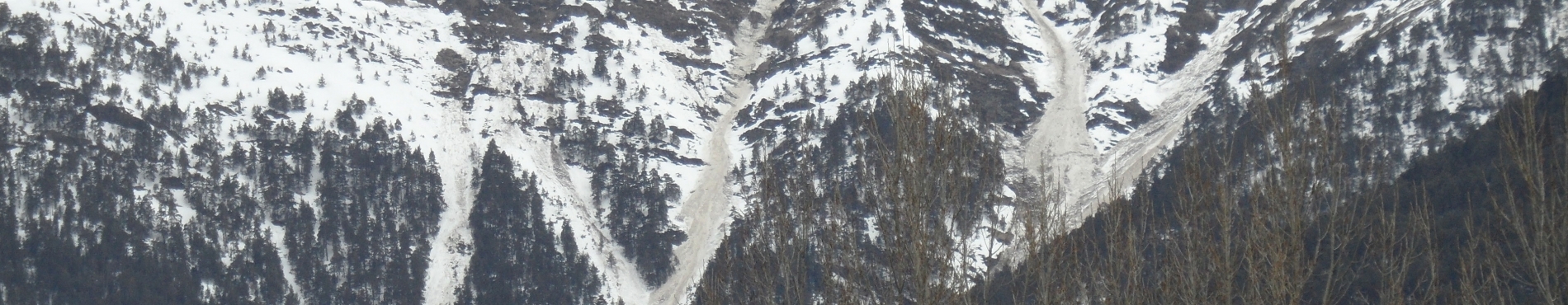
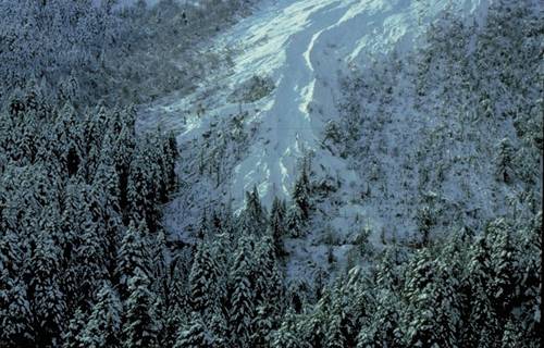
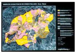
Work to map avalanche zones in the north of Andorra (1995-1996)
The aim of this project was to make field surveys of known avalanches in the Arcalís area for the mapping of avalanches in Andorra.
Institut Cartogràfic de Catalunya (ICC); Centre National du Machinisme Agricole, du Génie Rural, des Eaux et des Forêts (CEMAGREF), Grenoble, France.
Financed by: Conselleria d'Obres Públiques (Govern d'Andorra).
Contribution to the study of avalanche dynamics with the aim of hazard mapping. Training in modelisation in the field of natural phenomena (1994-1996)
The aim of this project was to study the dynamics of avalanches by means of modelling various pilot zones. Elaboration of methodologies for the mapping of avalanche zones. Integration into a geographic information system. This project had the benefit of researchers from other European countries who were working together with the ICC's avalanche and geographical information system (GIS) teams.
Institut Cartogràfic de Catalunya (ICC); Centre National du Machinisme Agricole, du Génie Rural, des Eaux et des Forêts (CEMAGREF), Grenoble, France; Universitat de Barcelona, Spain; École Polytechnique Féderal de Lausanne, Switzerland; Institut für Schnee und Lawinenforschung, Davos, Switzerland; Université Joseph Fourier, Grenoble, France; Norges Geotekniske Institutt (NGI), Oslo, Norway; Vedurstofe Íslands, Reykjavík, Iceland; Università di Torino, Italy.
Financed by: Directorate General XII for Science, Research and Development (Programme: Human Capital and Mobility) of the European Union.
