Information structure in the viewer
Conceptual diagram of the layer groups of the Geoindex viewer - Deep Geothermal
The Geoindex – Deep geothermal energy viewer is the main channel for disseminating the results of the project GeoEnergia-GP of ICGC (CP-III 2019-2022). The viewer is structured in 3 sets of information and currently contain 16 layers.
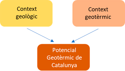
Geological context
This set of layers contains information about the geological structure and morphology of the lithosphere. Knowing the thickness and spatial variation of the lithosphere, the thickness of the crust and the main geological structures is essential to know and understand the deep thermal regime of Catalonia and to interpret the thermal anomalies accurately.
It also includes the information layer with the wells and boreholes inventory carried out for hydrocarbon (gas and oil) exploration in Catalonia and deep wells (approx. 1000 m or higher) for geothermal research. These boreholes allow to obtain primary data on the structure and geology of Catalonia as well as an approach to various thermal parameters. The location coordinates of the points have not been verified in all cases by the ICGC and correspond to those cited in the original source of the information. The information contained in the points has not been verified in all cases by the ICGC..
The layers included in this thematic group are the following:
- Deep wells and exploration boreholes.
- Major geological structures.
- Regional Bouguer anomaly (spatial distribution and isolines).
- Residual Bouguer anomaly (spatial distribution and isolines).
- Top elevation of autocton Paleozoic basement.
- Crust thickness (spatial distribution and isolines).
- Lithospheric thickness (spatial distribution and isolines).
Geothermal context
This set of layers contains the simulated layers of temperature at a crust scale, the surface heat flow, the distribution of thermal conductivities (inferred from the geological mapping at 1: 250.000 scale) and the thermal gradient.
The temperature distribution maps included in the Geoindex viewer were generated in the framework of the modelling works carried out by ICTJA-CSIC (2009) which consisted in modeling and simulation of heat transport in conductive regime and steady state using a generalized 3D model of the lithospheric structure assuming local isostasy. The model was implemented using LitMod3D software (Fullea, et al. 2009) with an 80x80x200 mesh. The lithosphere was modeled considering 3 layers: two layers for modelling the crust with constant values of radiogenic heat production and thermal conductivity and a third layer to model the mantle without radiogenic production of heat and constant thermal conductivity. The ‘LitMod’ methodology considers, among others, the effect of gravity, geoid, surface heat flow, petrological and seismic data (Carballo, et al. 2011). As a result of this modelling, temperature layers were obtained at the base of the crust and at 15 km, 7 km and 3 km depth.
The layers included in this thematic group are:
- Heat flow (spatial distribution and isolines).
- Geothermal gradient (spatial distribution and isolines).
- Thermal conductivity (spatial distribution and isolines).
- Temperatures at crustal base (spatial distribution and isotherms).
- Temperatures at 15 km of depth (spatial distribution and isotherms).
- Temperatures at 7 km of depth (spatial distribution and isotherms).
- Temperatures at 3 km of depth (spatial distribution and isotherms).
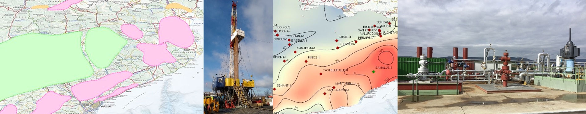
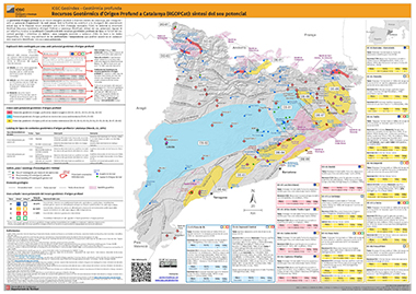
Deep origin geothermal potential in Catalonia
Based on geological and hydrogeological knowledge and on the identification of surface geothermal evidence (such as thermal manifestations), a map of the large areas with deep geothermal potential in Catalonia has been drawn up.
The possible reservoirs with geothermal potential identified by each zone have been classified according “Catalog of geothermal play types” defined by Moeck (2014), Moeck and Beardsmore (2014) i Moeck et al., (2015, 2019), according to the geological and structural context, the origin of the heat source and the dominant heat transport mechanism.
This viewer also includes a point collection with special and/or thermal water evidence. This layer, also contained in the Geoindex – Shallow geothermal energy viewer, includes spring waters or wells that capture thermal water at a temperature 4 ºC higher than the average annual air temperature in this place and/or carbonated, sulphuric or saline waters. In others, the point has been collected only by its toponym, indicative of a special mineral feature or indicative of a possible thermal character (spring waters such as: Font de la Puda, Font Calenta, etc.). It also includes drillings carried out in the 1970s and 1980s for the geothermal resources exploration in Catalonia (IGME) in which high geothermal gradients over 5 ºC/100m were measured. The location coordinates of the points have not been verified in all cases by the ICGC and correspond to those cited in the original source of the information.
The layers included in this thematic group are:
- Points with special and/or thermal water evidence.
- Areas of deep geothermal potential (v.2020).
References
Carballo, A., Fernández, M. & Jiménez-Munt, I. (2011). Corte litosférico al Este de la Península Ibérica y sus márgenes. Modelización de las propiedades físicas del manto superior. Física de la Tierra. Vol. 32. Núm. 1: 131-147. http://dx.doi.org/10.5209/rev_FITE.2011.v23.36915.
Fullea, J., Afonso, J. C., Connolly, J. A. D.,Fernàndez, M., García‐Castellanos, D., and Zeyen, H. (2009). LitMod3D: An interactive 3‐D software to model the thermal, compositional, density, seismological, and rheological structure of the lithosphere and sublithospheric upper mantle, Geochem. Geophys. Geosyst., 10, Q08019, https://doi.org/10.1029/2009GC002391.
Moeck, I.S., (2014). Catalog of geothermal play types based on geologic controls. Renewable and Sustainable Energy Reviews 37: 867–882. https://doi.org/10.1016/j.rser.2014.05.032.
Moeck, I.S., Beardsmore, G. (2014) A new ‘geothermal play type’ catalog: Streamlining exploration decision making. Procs. Thirty-Ninth Workshop on Geothermal Reservoir Engineering. Stanford University, Stanford, California, February 24-26, 2014. SGP-TR-202.
Moeck, I.S., Beardsmore, G., Harvey, C.C (2015). Cataloging Worldwide Developed Geothermal Systems by Geothermal Play Type Proceedings World Geothermal Congress 2015. Melbourne, Australia, 19-25. April 2015.
Moeck I.S., Dussel M, Weber J, Schintgen T, and Wolfgramm M. (2019). Geothermal play typing in Germany, case study Molasse Basin: a modern concept to categories geothermal resources related to crustal permeability. Netherlands Journal of Geosciences, Volume 98, e14. https://doi.org/10.1017/njg.2019.12.
Puig, C.; Serra, L.; Marzan, I.; Fernández, M.; Berástegui, X. (2013). El Atlas de geotermia de Catalunya: Un instrumento en Evolución. Congreso Aspectos Tecnológicos e Hidrogeológicos de la Geotermia. pp. 227-237. AIH-GE. Barcelona 2013. ISBN 978-84-938046-3-0.
Project carried out with the collaboration of:

 Contact