
 Contact


The more important urban centers in the affected region and different rural zones were visited (See map in figure 3).
Alhoceima
City with many constructions of Spanish colonial period, with a urban population of 70.000 inhabitants. The city is located on rock outcrops and although being located at less than 10 km from the epicenter of the main earthquake, the damages are light; there are no collapses or severe damages. There are many buildings of good quality (type C) with cracks and grade 2 damages. Possibly the intensity EMS has been VI o VII. As an example, the Hotel Mohammed V, constructed during the years of Spanish presence does not shows any major damage. The high number of aftershocks had caused the population to feel insecure in their houses so that they sleep in tents even located in the city square or "Plaza Mayor" (Photo 7).

Photo 7. Camping site at the "Plaza Mayor" of Al-Hoceima.
Imzouren
City almost as important as Al Hoceima, but of constructive and location characteristics very different. The city extends along 3 km in the left margin of the Oued Nekkor and occupies part of the recent alluvial plain and more ancient terraces (of light topography) of the Oued Nekkor and the Oued Rij (figure 3), composed of conglomerates, sandstones and silts of Pliocene age.
It is a city, where recently, money from the migration to Europe is invested on multiple buildings of First Floor + 2, 3 or 4 stories. These buildings have reinforced concrete columns and beams with masonry walls like those found in many regions of Spain.
The infrastructure are rudimentary, for example the majority of the street are without asphalt, there are no sewage, the out of town constructions does not follow any regulation and spread to the hills close to the rural areas. Many damaged buildings are observed (over 30 have collapsed) and many others are in good shape.
The Regional Urbanism Agency with the support of the French ONG: Emergency Architects were performing a damaged building census, and we had the opportunity of having several meetings with them, of which will account in the following paragraph.
It is very difficult to set the intensity value for the city due to the great dispersion observed: damages grade 5 in buildings type B or even C and damages grade 0 in many buildings type C (or B). It should de waited for the results of the work performed by the Regional Agency to obtain the total distribution of damages. Probably, the presence of not very consolidated soils and some constructive practices play a key role in this damage distribution.
To contribute to the explanation of this damage distributions we performed during the visit the recording of microtremors in some 10 points in the city, characterized by the existence of damages of different grades: from 0 to 5 and in different points within the city. Three figures are shown with the measurements performed in front of two collapsed buildings and one without visible damages (Photos 8, 9, 10, 11, 12, 13 and Figures 4, 5 and 6). The tendency of the spectral relationships (Nakamura method) does not seem revealing of greats amplifications, based on the first results obtained.
Photos 8 and 9. Recording site of seismic noise near to a collapsed building (damage degree 4-5). Location in figure 3.
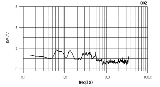
Figure 4. Spectral relation of the recording site location of the photos 8 and 9.
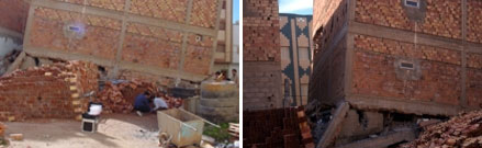
Photos 10 and 11. Collapsed building and detail view where a seismic noise measurement was recorded (damage degree 4-5). Location in figure 3.
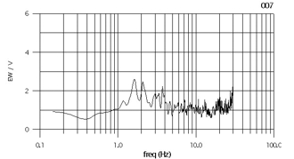
Figure 5. Spectral relation of the recording site location of the photos 10 and 11.
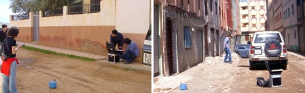
Photos 12 and 13. Recording sites near to an adjacent street close to the 10 and 11 photos sites. Location in figure 3.
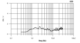
Figure 6. Spectral relation of the recording site location of the photos 12 and 13.
Ajdir
Is an urban center smaller and more disperse that the previous one, also located on the terraces of the mentioned Oueds and closer to the epicenter and to the probable fault causing the seismic crisis. The damages seem more important and more uniformly distributed. Many very damaged buildings (grade 3 or 4) and of an apparent good quality (C) had been observed and several microtremors measurements were performed in front of different buildings (photos 14, 15, 16 and figure 7). The intensity seemed to be higher than VIII degree.
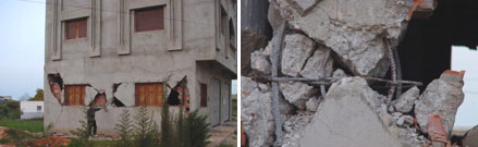
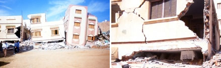
Photos 14 and 15. Building and flattened pillar. It seems that the intensity seems to be greater than VII degree. Location in figure 3.
Photo 16. Damages detail. Location in figure 3.
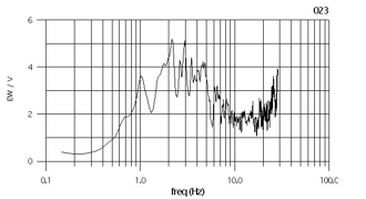
Figure 7. Spectral relation of the recording site location of the photos 14, 15 and 16.
Izmourenne
Is a center combining rural and urban styles, located on a high site, outside the plain of the oueds, over soils formed by layers of "nappes de flysch" and in the presence of important alluvial fans. The damages seem to be also important. Several microtremors measurements were performed in front of some buildings (photos 17, 18 and figure 8).
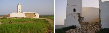
Photos 17 and 18. Damages at the Izmourenne mosque. Location in figure 3.
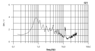
Figure 8. Spectral relation of the recording site location of the photos 17 and 18.
Rural zones of Ait Kamra and Ifassayenne
These are two characteristic zones of great surface located near the seismic rupture were fractures had been observed in the terrain that can indicate a closeness to the rupture. In these zones many collapsed one story houses had been observed constructed traditionally with rock and adobe. Groups of houses are located dispersed through the town. In these zones many victims have been reported due to the collapse of very heavy roofs, many damages grade 5 in type A constructions (photos 19 and 20).
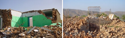
Photos 19 and 20. Damages of the 5 degree in buildings of A class. Location in figure 3.
Mohamed Abde El Karim El Khatabi dam
It is an earth dam located over the Oued Nekkor about 20-30 km from the epicenter. According to the manager of the hydraulic's office of Al Hoceima, the dam did not suffered damages during the main earthquake. The accelerometer at the dam recorded the main earthquake with acceleration near 0.20 g.
Installation for liquation of gas GPL at Izmourenne
It is a gas liquation plant for filling gas cylinders for domestic use. It is the location of accelerometer (GAS). A 2000 m3 deposit exists, supported by 8 columns of 1m in diameter with 8m buried. The deposit resisted the shaking, according to the person in charge of the plant, Mr. Temsmani Mohammed. Besides the loss of electricity during more than 36 hours the plant continued working manually. There was certain restlessness for the state of some machinery buildings because of the degradation caused by the numerous aftershocks.
