
 Contact


The earthquake was located in the northern coast of Morocco, near the city of Al Hoceima, with Mw=6.5 according to CSEM and a shallow depth of less than 10km according to the Morocco agencies: SPGM and CNRM.
The earthquake is located in the central part of the limit between the Iberian and African plates (Figure 1). This zone is characterized by a seismicity more diffuse than the neighboring zones of the Cadiz Gulf to the west and of Algeria to the east. Recent studies (Buforn et al., 2004) had evidenced a deficit in the seismicity during the XXth century, with respect to the neighboring zones, that could be interpreted as an abnormal period of seismic calm during this century. Previously, during XIXth century, two earthquakes occurred in Southern Spain with M>6 (1829 and 1884) with destructive effects.
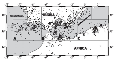
Figure 1. Seismotectonic context of the collision between the Iberia-Africa tectonic plates (Buforn et al., 2004).
In the same zone, in 1994 (Bezzegoud and Buforn, 1999) took place an earthquake with a magnitude close to 6, with less damage than the recent earthquake of February 2004.
At a regional scale, the Plioquaternary formations are located on the perimeter of the RIF, in particular near the coast, where the tectonic deformations are more studied (J.L. Morel (1988, 1994) and L. Ait Brahim (1990, 1991, 1997).
The type of structures associated to the most important deformations (Figure 2) are the following:
- the major left lateral NE-SW strike-slip faults (Al Hoceima, Nekor, Saïss, Melilla),
- the reverse faults (internal/ external Rif, the pre-Rif frontal thrust), limited or cut by the previous mentioned structures,
- he folds of big curvure radius (Ketama, region of Tanger),
- a system of normal, neoformated faults, bordering subsidence zones of quaternary sediments (Al Hoceima graben, with thicknesses of 400 m).
The main faults seem to be organized in function of the probably crustal strike-slip faults of Jebha and of the system of Al Hoceima/Nekor/Saïss/Melilla, all them on a compressive stress field of N-S to NW/SE direction.
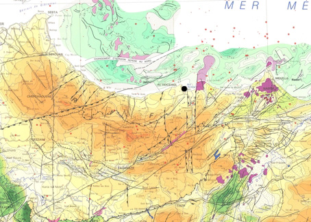
Figure 2. Tectonic map (Service Géologique du Maroc, 1984).
