The catalogue of seismicity is presented in this first volume, being a compilation of all the available data concerning earthquakes occurred in Catalonia and near areas, felt by the population since historic times.
The most relevant catalogues and studies realized up to now has been taken into account and a high degree of homogenisation and reliability of the presented data have been obtained. Data are presented on different ways: epicentral maps of the most damaging earthquakes in order to have a quick view of the distribution and importance of the occurred earthquakes; a list of the epicentral characteristics of all the earthquakes and 917 individual cards or forms describing each earthquake.
On the web page an abstract of the volume is showed, with maps and the list of the totality of earthquakes.
Epicenter maps
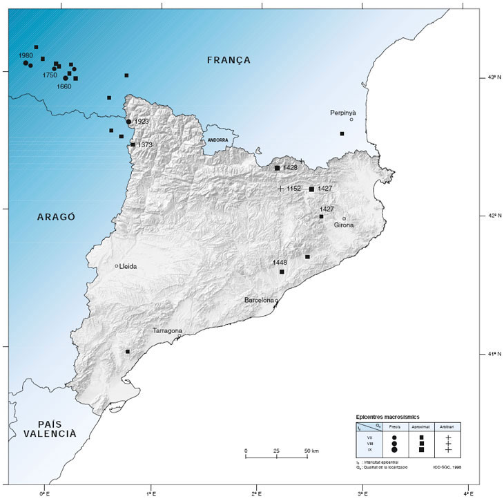
Map 1: Epicenters of damaging earthquakes
Epicenters of all known damaging earthquakes in the considered region from historical times to the present with Io >= VII.
Different symbols are used to indicate their location precision (Qe).
Size of symbols are related to epicentral intensity (Io).
When the intensities are defined by two values (ex. VIII-IX) the size of the symbol corresponds to the low value (ex. VIII).
The year of the earthquake occurrence appears for epicentral intensities Io >= VIII.
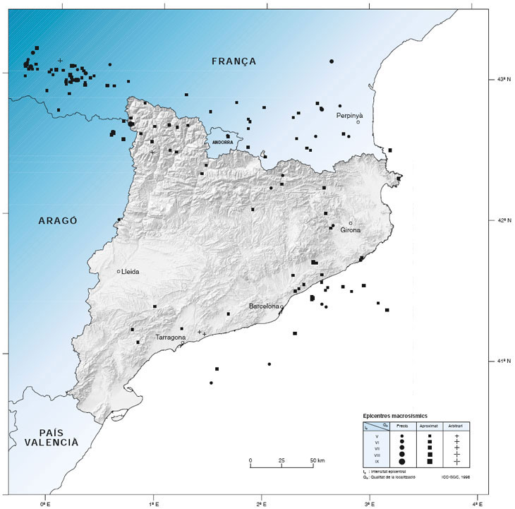
Map 2: Epicenters of earthquakes strongly felt occurred during the XX century
The mapped epicenters correspond to the totality of earthquakes occurred during the XX century, strongly felt, with epicentral intensity (Io) greater or equal to V.
Different symbols are used to indicate their location precision (Qe).
Size of symbols are related to epicentral intensity (Io).
When the intensities are defined by two values (ex. V-VI) the size of the symbol corresponds to the low value (ex. V).
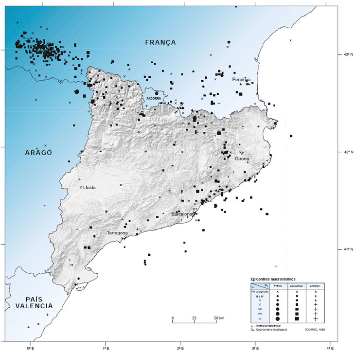
Map 3: Epicenters of all the earthquakes considered in the catalogue
The epicenters of all earthquakes considered in the seismic catalogue are shown including those with an arbitrary epicenter and those without assigned intensity.
Different symbols are used to indicate their location precision (Qe).
Size of symbols are related to epicentral intensity (Io). When the intensities are defined by two values (ex. V-VI) the size of the symbol corresponds to the low value (ex. V).
Epicenters of felt eartquakes without an assigned intensity are indicated by a cros (x).
Table of macroseismic epicenters
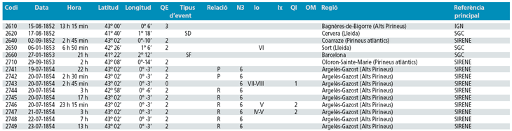
Detail of the table of macroseismic epicenters
Legend
- Identification code of the earthquake in the database (Codi). This is an internal reference number that identifies it.
- Date and time of the earthquake (Data, Hora). Sometimes only an imprecise indication of the date appears.
- Coordinates of the epicentre (Latitud, Longitud). in degrees, minutes and seconds. In the case of earthquakes before 1900, these are given in degrees and minutes.
- Quality of the epicentre (QE).Values between 0 and 3 are given according to the following criteria:
- 0. When there is sufficient macroseismic information available to reliably site the epicentre of the earthquake.The accuracy in sitting the seism is to within a few kilometres or there has been recourse to instrumental determination for recent seisms.
- 1. When there is sufficient macroseismic information available to approximately site the epicentre of the earthquake. The accuracy in this case may be to within 10-20 km.
- 2. When there is little macroseismic information available and therefore the epicentre is imprecisely sited. Accuracy is to within tens of kilometres.
- 3. When the information available comes from a single place or region. In these cases the epicentre is arbitrarily sited.
- Type of event (Tipus d'event). This field is used to indicate false or doubtful events.
- Relationship (Relació). It is indicated if the earthquake is an aftershock (R) or premonitory ((P) of a principal seism.
- N3. The significant seismic series are indicated by a series identification number for each earthquake forming part of a series.
- Epicentral intensity (Io). deduced from the maximum felt when it is known, or provided by the source considered.
- Maximum intensity felt (Ix). This is only indicated when it is different from the epicentral intensity, e.g. for earth-quakes occurring offshore or in order to take local effects into account, since for the majority of earthquakes Ix coincides with the epicentral intensity.
- Quality assigned to the intensity value (QI) when information is held about its precision. The value 1 indicates greater precision than the value 2. No value appears when the intensity has not been checked, when it is unknown or when the seism is false or doubtful.
Number of macroseismic observations (OM). Corresponds to the number of places for which macroseismic information is available. - Region of the epicentral zone (Regió). A characteristic name is given for the epicentral zone; this may coincide with the name of a place or a comarca, or more imprecisely, with the name of an entire natural area.
- Main reference Referencia principal. Corresponds to one of the IGN, FONT, SURO, SIRENE or SGC catalogues from where the information has been extracted.

 Contact