
 Contact


The focal mechanism obtained by the different centers represents a N20ºE left lateral strike-slip fault, in agreement to the directions of the main accidents in this part of the Rif (Figure 2).
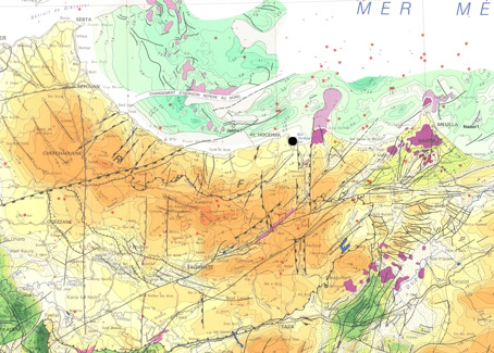
Figure 2. Tectonic map of the study area.
The positions of the different localizations of the main earthquake reported by different centers had been represented in the regional geologic map (Figure 3) at a scale of 1:50.000:
- CSEM: 35.2º N 4.0º W (European-Mediterranean Seismological Centre).
- USGS: 35.235º N 3.963º W (National Eartquake Center, USA).
- IGN: 35.142º N 3.997º W (Instituto Geográfico Nacional, España).
- SPGM: 35.190º N 3.996º W (Centre de Physique du Globe, Rabat Agdal, Morocco).
- CNRM: 35.22º N 3.90º W (Centre National de la Recherche Scientifique et Technique, Rabat, Morocco).
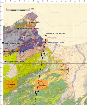
Figure 3. Geologic map at 1:50.000 scale (Service Géologique du Maroc, 1984). The black dots correspond to the epicentral locations by diferent institutions. The blue triangle are the accelerometric sites. The red cercles correspond to the diferent observations in buildings and the orange hatched areas are the recognised zones by the fieldtrip. The black dotted line correspond to the possible fault trace.
The rupture length, according to the accepted empirical relations, for an event of Mw=6.5 correspond to 20-30 km and the horizontal displacement of the fault is approximately 1 meter.
The observations made in the field during our visit and those of different teams (personal communication with Ben Brahim, after a field visit and an helicopter survey) had no allowed to show the existence of surface ruptures. Against that it be followed over the field during hundreds of meters in different places. In the map of Figure 3 are indicated our observations near the beach at the Club Mediterranée and the Ifassayenne region (Photos 1 to 4). It is very possible that these fractures had occurred over the seismic rupture because they follow directions close to the direction of the fault given by the focal mechanism, that is approximately N20º E.
