Acces to the full screen viewer
The application allows to visualize and compare the following images:
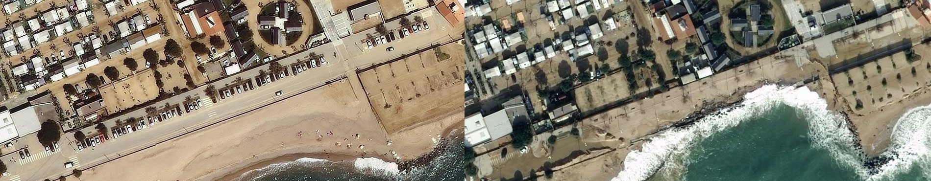
- Current orthophoto: Last conventional orthophoto published by the CGC. Pixel size 25 cm.
- Orthophoto 2016: Conventional orthophoto published by the ICGC, with images captured in 2016. Pixel size 25 cm.
- Temporary January 2017: Orthophoto made from aerial photographs of the entire coastline of Catalonia, captured on January 24 to assess the effects of the storm of January 21 and 22, 2017. Pixel size 25 cm.
- Temporary March 2018: Orthophoto made from aerial photographs of the areas affected by the storm of March 1 and 2, 2018. The flight of the Badalona-Roses section was carried out on March 6 while the section of Cap de Creus was made March 16 Pixel size 25 cm.
- Costa Febrer 2019: Orthophoto made from aerial photographs of the entire coastline of Catalonia, captured in February and with a pixel size of 15 cm.
- Temporary April 2019: Orthophoto made from aerial photographs of the areas affected by the storm on April 19 and 23, 2019. The flight of the Ampolla-Blanes section took place on April 26 while the Blanes-Roses section was made on May 4th. Pixel size 15 cm.
- Temporary October 2019: Orthophoto made from aerial photographs of the affected areas of the storm from October 22 to 24, 2019. The orthophoto comprises the stretch from Cambrils to Sitges and the section from Badalona to Sant Pere Pescador flown on October 27. Pixel size 25 cm.
- Temporary December 2019: Orthophoto made from aerial photographs of the areas affected by the storm on December 4 and 5, 2019. The flight of the Castelldefels-Roses section took place on December 7 while the flight of the Delta de l 'section Ebre-El Vendrell was made on December 10. Pixel size 10 cm.
- Delta de l'Ebre January 2020: Orthophoto made from satellite image captured on January 16 with ESA Sentinel-2 satellite. Pixel size 10 m (days 16, 23 and January 26, 2020).
- Temporary Gloria: Orthophoto made from aerial photographs of the areas affected by the temporary Gloria. Ebro delta, January 24, 2020 with pixel size 15 cm; Ebro delta- Tordera, January 26, 2020 with 10 cm pixel size; Tordera - Cabo de Creus, January 27, 2020 with 10 cm pixel size.
- Delta de l'Ebre February 21, 2020: Orthophoto made from aerial photographs of the Delta de l'Ebre one month after storm Gloria. Flown on February 21 with a pixel size of 10 cm.
- Temporary Filomena: Orthophoto obtained from photographs of the Delta de l'Ebre coastline captured on January 12, 2021 with a pixel size of 15 cm.
- Affects Montsià September 2021: Orthophoto made from aerial photographs of the areas affected by the floods of the Montsià streams. Images captured on September 3, 2021. The area near the coast between Alcanar and Sant Carles de la Ràpita has a pixel size of 5 cm while the rest has a pixel size of 15 cm and has partial cloud coverage.
- Storm Celia March 2022: Orthophoto made from aerial photographs of the areas affected by Storm Celia. Maresme Nord and Barcelona flight on April 4, 2022, Baix Llobregat, Tarragonès and Delta de l’Ebre flight on April 8, 2022 with a pixel size of 10 cm.
- Storm Isaak February 2023: Orthophotos made from images from the Pléiades Neo satellite of the areas most affected by Storm Isaak. Barra del Trabucador on February 12, Badalona on February 13, 2023 and Tarragona-Calafell on February 14, 2023, all with a pixel size of 30 cm.
- DANA from September 2-3, 2023: Orthophoto made from aerial photographs of the areas affected by Dana, flight on September 6, 2023 with a pixel size of 10 cm.
- Storm Nelson March 27-31, 2024: Orthophoto made from aerial photographs of the areas affected by Storm Nelson, flights carried out on April 3, 5 and 6, 2024 with a pixel size of 10 cm.
The comparison of the images can be done in two ways:
- Placing the same area on one side and another of the window; when moving one image, the other moves in the same direction.
- By sweeping the image, using the central button, so that changes are focused on a specific point.
This tool also allows you to obtain a link to the viewer focused on a certain area, as well as with the HTML code (iframe) in case you want to insert it into your web page or blog.
This publication serves the different professionals who need to assess the damage caused by these storms in the Catalan coast

 Contact