
 Contact


Map to assess the amplification of the movement produced by an earthquake
When an earthquake occurs, soil behavior can be very different depending on the geomechanical characteristics of the materials that form it. In those cases where the soil is composed of soft and / or unconsolidated materials, seismic waves can be amplified, as can be seen in Figure 1, causing damage to buildings even in areas far away from the epicenter. Increases in the amplitude and duration of soil movement have also been observed when seismic waves propagate through certain subsoil geometries or topographic reliefs. In most destructive earthquakes of recent years such as Michoacan 1985 (Mexico), Loma Prieta 1989 (California, United States), Kobe 1995 (Japan), Izmit 1999 (Turkey), Aquila 2009 (Italy), Maule 2010 (Chile ) and Tohoku 2011 (Japan) has been able to verify the importance of the amplification of the seismic movement due to soil effects in the distribution of damages. We must take into account this phenomenon of amplification in territorial planning, in the design of anti-earthquake structures (standards of seismic-resistant construction) and also in the assessment of the seismic safety of buildings already built.
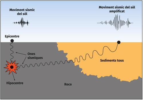
Figure 1. Scheme of the effect of amplification of the movement of the soil where the increase of the amplitude of the seismic waves that occurs in soft sediments with respect to the movement of the ground in hard rock is observed.
The Seismic Mesozonization Map of Catalonia 1: 250,000 (2018) presents the seismic amplification based on the terrain for the entire territory.
The legend of the map is based on a classification of the soil (from A to E) inspired by the European regulations for seismic resistant construction, called Eurocode 8 (CEN, 2004). The classification of soils of the seismic mesozonation of Catalonia takes into account the resistance of the surface terrain, its thickness and the contrast with the resistance of the underlying soil, factors that allow to estimate the effects of amplification of seismic waves. The map describes the process of realization of the same, with indications of what are the mechanical characteristics of each type of soil and the different thicknesses considered. The characterization of the seismic amplification of each soil type is also shown, both in terms of degrees of macrosefficiency intensity and acceleration response spectra used in the calculation of structures.
Classification of soils
Classificació del terreny segons la Mesozonació sísmica de Catalunya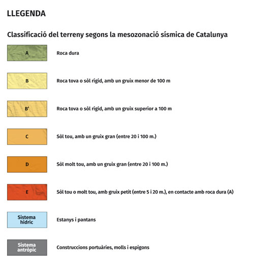
Soil classses
- Class A: soils in which well-consolidated rock emerges or is covered with a thickness of soft material less than 5 m.
- Class B: soils formed by very dense sand or bass, very rigid clays or sedimentary rocks with a degree of medium consolidation, with a thickness less than 100 m and with a coating less than 20 m of soft or very soft terrains. Below these materials is a well-consolidated rocky substratum.
- Class B’: soils formed by very dense sands or bush deposits, very rigid clays or sedimentary rocks with a degree of medium consolidation and with a thickness exceeding 100 m.
- Class C: soils formed by sand or dense deposits and rigid clays with thickness ranging from 20 to 100 m and covering a rock substrate.
- Class D: soils formed by deposits of fine sand and dense slabs or rough clays to medium rigid ones of a thickness that oscillates between 20 and 100 m and that cover a rock substrate.
- Class E: lands formed by deposits of fine sand and dense slabs or soft clays of medium to rigid thickness ranging between 5 and 20 m and that cover a well-consolidated rock substrate (class A).
Mapa de mesozonació sísmica de Catalunya a escala 1:250.000 (versió reduïda) (Edició 1a v2, 2020; Descàrrega GeoPDF 15 MB)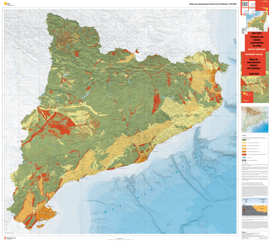
Map realization
The map has been made based on a modification of the classification of Eurocode 8 (CEN, 2004) adapted to the particularities of Catalonia. First, lithological characteristics have been assigned to the units of the Geological Map of Catalonia 1: 50,000 from the ICGC starting from the geomechanical surface classification proposed by Fleta et al. (1998), completed by Saula (2011) and reviewed based on the geotechnical data available. Subsequently, thicknesses have been assigned to quaternary and neogene units. Finally, all the information has been crossed in order to classify the land according to the classes contemplated in the seismic mesozonation of Catalonia (IGC, 2013).
This map has been carried out within the framework of the Special Plan for Seismic Emergencies of Catalonia (SISMICAT) in which the ICGC has worked actively since its implementation.
Assignment of the mechanical characteristics to the lithographic units
The units of the Geological Map of Catalonia 1: 50,000 have been classified into 4 groups according to the range of speeds of the shear wave propagation. For the litological characterization of each unit, a review has been carried out following geotechnical criteria. Vs velocity correlations have been used with those of the Standard Penetration Test SPT (N30) and non-drained cutting resistance (Cu) (Table 1).
Lithological classification | Shear speed | SPT | Resistance to non-drained cutting |
|---|---|---|---|
Roca dura (HR) | > 800 | - | - |
Roca tova i sòl dur (SR) | 360 – 800 | > 50 | > 250 |
Sòl tou (SS) | 180 - 360 | 15 - 50 | 70 - 250 |
Sòl molt tou (VSS) | < 180 | < 15 | < 70 |
Table 1. Geomechanical classification from the shear wave propagation velocity values, correlated with SPT values and non-drained (Cu) resistance values.
Lithological classifications are defined below:
- HR - Hard rock: granites, slates, limestones, sandstones, etc. Rocks usually of Palaeozoic, mesozoic or tertiary Paleocene ages.
- SR - Soft rock and rigid soil: sandstones and limogs with low degree of consolidation or very rigid clays. Generally of neogene tertiary age or Quaternary Pleistocene.
- SS - Soft soil: deposits of clays, arenas and dense gravels and slightly carbonated clays. Generally from Paleocen to Quaternary agea.
- VSS -Very soft soil: deposits of sand, slime and recent clays of delta environments. Generally from holocene quaternary ages.
Characterization of the thickness of the layers
In determining the thickness of the different layers that form the vertical structure of the soil, the four thickness intervals have been taken as a reference.
Class | Range of thicknesses (m) |
|---|---|
Very small | 0 - 5 |
Small | 5 - 20 |
Great | 20 - 100 |
Very big | >100 |
Taula 2. Rang de gruixos considerats.
The allocation of the thickness intervals of the layers has been done based on bibliographic data and survey data, considering the type of deposits and their location.
Classification of soils
The crossing of the information obtained from the lithological classification obtained from shear waves (Vs) and the thickness of the layers, resulted in a representative soil column with a maximum of 3 layers (Figure 2).
The classification proposed by Eurocode 8 (EC8) in the Map of seismic mesozonation of Catalonia 1: 250,000 has been modified taking into account the results of the works carried out in the SISPYR project (IGC, 2013), obtaining 6 types of soil. This classification of seismic mesozonation does not take into account the classes S1 and S2 considered in the EC8, since they are not present in the territory; and enter the class B ', which includes soft rocks with a thickness greater than 100 m. Figure 2 shows the layout of the lithological columns of the different kinds of land of the seismic mesozonation of Catalonia.
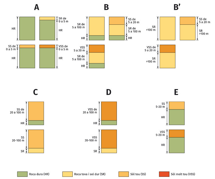
Figure 2. Diagram of the lithological columns associated with each type of spoil in the seismic mesozonation of Catalonia.
Amplification of the seismic movement of the soil
This amplification is shown in terms of spectra of response in acceleration and increases in macroseismic intensity.
a) Normalized acceleration response elastic spectra
Acceleration response spectra can be obtained with the following formulation proposed in Eurocode 8:
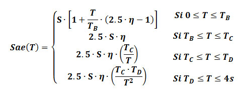
where:
Sae (T) = elastic spectrum of response in normalized acceleration
T = vibration period of a linear system of one degree of freedom
S = amplification factor corresponding to each soil class
η = correction factor for damping (1.0 if the damping is 5%)
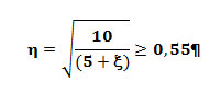
ξ = damping percentage
TB, TC i TD = constants that control the shape of the response spectrum
The effect of amplification of the different soil classes proposed by the seismic Mesozonation of Catalonia has been characterized by elastic spectra of response in acceleration with 5% of damping. Table 3 shows the different parameters that define the shape of the spectrum for each soil class. These spectra (figure 3) are standardized with respect to the maximum value of ground acceleration (PGA) and are based on the definition of type 2 spectra of EC8 modified during the work carried out in the SISPYR project (IGC, 2012b).
Classe of soil | S | TB (s) | TC (s) | TD (s) |
|---|---|---|---|---|
A | 1.00 | 0.05 | 0.25 | 1.20 |
B | 1.35 | 0.05 | 0.25 | 1.20 |
B’ | 1.20 | 0.05 | 0.35 | 1.20 |
C | 1.50 | 0.10 | 0.30 | 1.20 |
D | 1.60 | 0.10 | 0.30 | 1.20 |
E | 1.80 | 0.05 | 0.20 | 1.20 |
Table 3. Proposed values of the parameters of the normalized acceleration response elastic spectra. S: amplification factor; Tb-Tc periods that define the flat part of the spectrum; Td: period that indicates the change in slope of the curve.
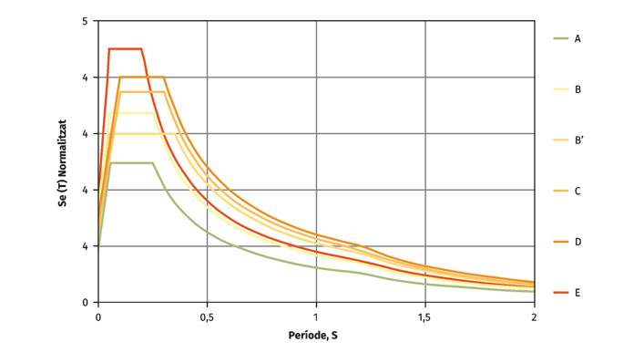
Figure 3. Diagram of the lithological columns associated with each type of soil in the seismic mesozonation of Catalonia.
In order to obtain the elastic response spectrum in acceleration of a site, the class of soil must be determined on the map and scaled to the PGA value corresponding to hard rock associated with the site or municipality studied. The PGA values are obtained from a regional hazard analysis calculated for a type A reference soil with a higher shear wave velocity of 800 m / s (CEN, 2004), such as the one carried out in Catalonia on year 2008 (ICGC-GEOTER, 2008), provided that these PGA values are equal to or higher than those recommended by the current Earthquake Standards (NCSE-02, 2002).
b) Macroseismic intensity increases (∆I)
Table 4 shows the increases in macroseismic intensity with respect to the intensity in rock for each class of terrain of the seismic mesozonation of Catalonia, according to the results of the SISPYR project (IGC, 2012a; IGC, 2012b) and the Macau study (2008).
Class of soil | A | B | B´ | C | D | E |
|---|---|---|---|---|---|---|
∆I | 0 | 0,5 | 0,5 | 1,0 | 1,0 | 1,5 |
Table 4. Increases in intensity for the different soils classes of the seismic Mesozonation of Catalonia according to IGC (2012) and Macau (2008).
Maps of seismic mesozonation and seismic hazard
In this section we present a series of maps where the isolines of the maximum acceleration values (PGA, in g) obtained in the last update of the seismic hazard map of Spain (Martínez Solares et al., 2017) are superimposed on the Map of seismic mesozonation of Catalonia. Two maps of Catalonia are presented, showing the PGA isolines corresponding to the return periods of 475 (10% probability of exceeding 50 years) and 975 years (5% probability of exceeding 50 years). Detail windows are also shown for 7 areas of Catalonia with the PGA corresponding to the return period of 475 years. The PGA values shown should serve as the basis for the new Spanish seismic construction standard.
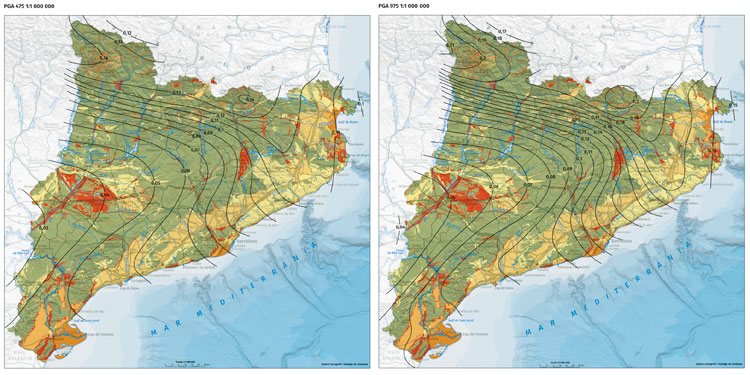
Isoline maps of the maximum acceleration values (PGA, in g) corresponding to the return periods of 475 (10% exceedance probability in 50 years) and 975 years (5% in 50 years)
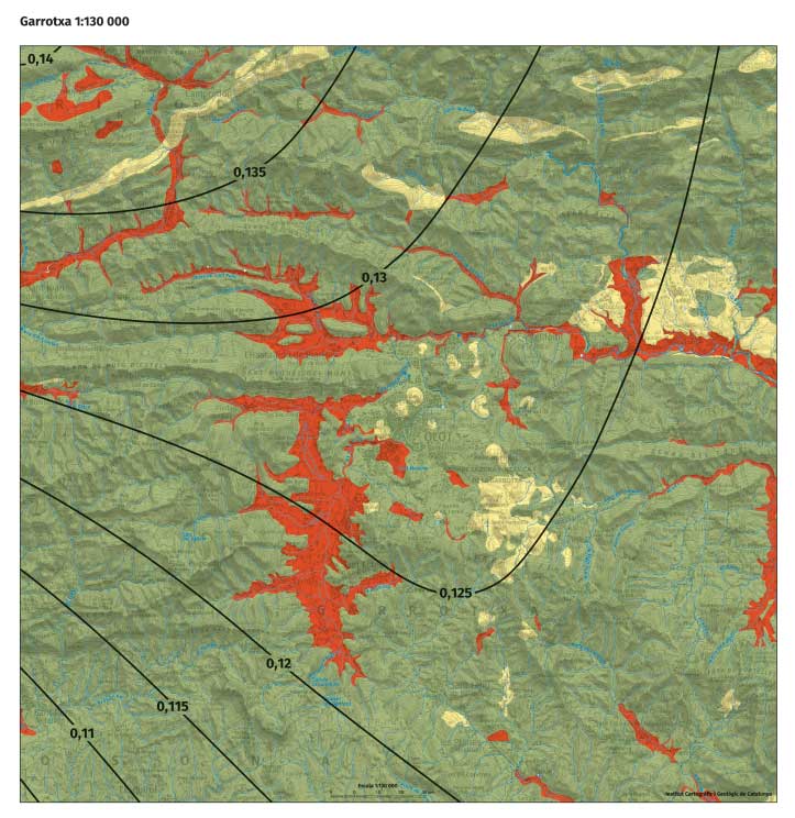
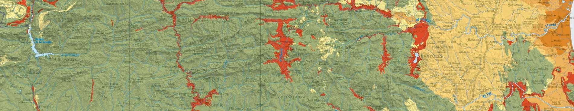
Detail of the map in the area of the Garrotxa
These maps provide information on geological characteristics and physical parameters of the terrain, and are useful for studies of seismic risk at the municipal level. The soil classification of the mesozonation represents a first estimate of the effects of soil, very useful in case of not having more detailed studies. This first approach allows to include the possible effects of soil in scenarios of seismic damage both in a regional and inframunicipal scope. In this way, it is possible to identify the areas that could be most affected by an earthquake and contribute to the drafting of urban planning and action plans in the event of a seismic emergency.
References
CEN (2004). Eurocode 8: Design of structures for earthquake resistance – Part 1: General rules, seismic actions amb rules for buildings. European Committee for Standardization, EN 1998-1:2004.
Fleta, J.; Estruch, I. i Goula, X. (1998). Geotechnical characterization for the regional assessment of seismic risk in Catalonia. Procs. 4th Meeting of the Environmental and Engineering Geophysical Society, pp. 699-702. Barcelona.
ICGC-GEOTER (2008). Càlcul probabilista de la perillositat sísmica a Catalunya en acceleracions espectrals. Document GTB/IGC/0508-001. Institut Geològic de Catalunya.
IGC (2012a). Microzonació sísmica de nivell avançat a l’àrea urbana de Girona. SYSPIR, Informe ICGC.GA-009/12, 67 pp.
IGC (2012b). Shake-Map: Site effect corrections. Institut Geològic de Catalunya, Informe ICGC.GS-021/12, 182 pp. http://bit.ly/2rycRMA, Darrera consulta: 23/octubre/2018.
IGC (2013). Mapa de Mesozonació sísmica de Catalunya (1:100 000), adaptat a la classificació EC8 (versió 2013), Institut Geològic de Catalunya, Informe ICGC.GS-001/13, 148 pp.
Macau, A. (2008). Microzonación sísmica. Contribución a los estudios de peligrosidad sísmica a escala local en zonas rurales y urbanas. Tesi Doctoral, Universitat Politècnica de Catalunya, 328 pp.
Martinez Solares, J. M.; Cabañas, L.; Benito, M. B.; Rivas, A.; Gaspar, J. M.; Ruíz, S. i Rodríguez, O. (2017). Actualización de mapas de peligrosidad sísmica de España 2012, Centro Nacional de Información Geográfica i Instituto Geográfico Nacional, Madrid, Espanya, https://bit.ly/2Ao1IVb, Darrera consulta: 23/octubre/2018.
NCSE-02 (2002). Real Decreto 997/2002, de 27 de septiembre, por el que se aprueba la norma de construcción sismorresistente: parte general y edificación (NCSR-02). Ministerio de Fomento. Fecha de publicación: 11-10-2002. BOE: 244-2002, pp. 35898-35966.
Saula, E. (2011). Mapa de propietats geomecàniques per a la consideració de l’amplificació del moviment sísmic del sòl a escala 1/250 000. Institut Geològic de Catalunya, Informe ICGC.CG-030/10, 74 pp.
