The two-dimensional approximations of the geological structures imply a series of errors and simplifications that are solved or minimized with the modeling of the structures and the rocky bodies in three dimensions.
This tool allows to develop a more dynamic and reliable work methodology, as well as a better understanding of the subsoil geology.
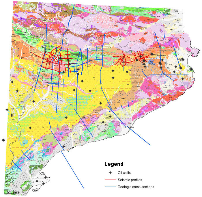
Data source of the 3D geological model
Methodology
The works of 3D geological modeling have been developed through the collaboration with the Institut de Recerca Geomodels of the Universitat de Barcelona during the year 2010.
The model elaborated constitutes an initial version that will evolve and improve its resolution with the incorporation of new information acquired through the realization of the Geoworks.
For the elaboration of the model of have performed the following tasks:
Acquisition of the necessary data:
- Compilation of the Institute's geological information
- Compilation of surface and subsurface geological information complementary to that of the Institute
- Classification and evaluation of information quality
3D digitization:
- Harmonization and homogenization of formats
- Storage of information in the appropriate technological environment
Elaboration of the geometric model:
- Reinterpretation of information in the regional geological context. Quality controls
3D modeling tasks:
- Construction of 3D surfaces and verification of consistency (quality controls)
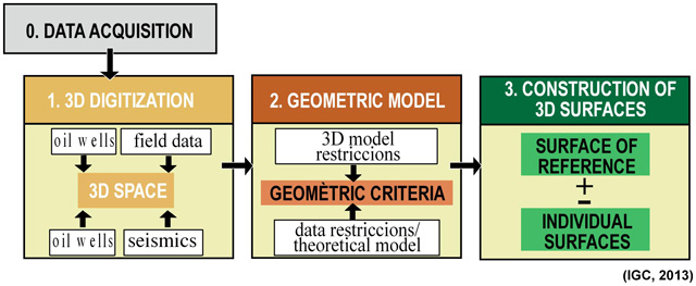
Quadre summary of the methodology adopted
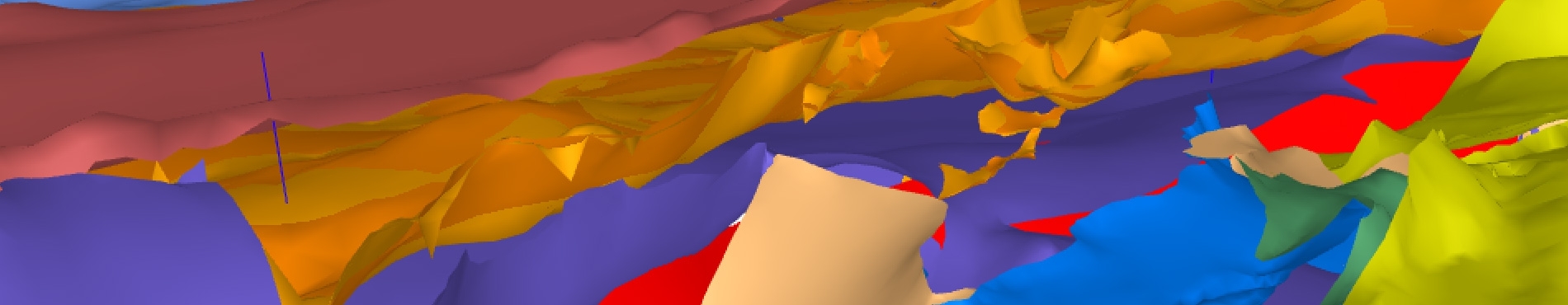
Geological surfaces considered in the elaboration of the 3D Model
Stratigraphic discontinuities:
- Paleozoic roof (hercinian discordance)
- Base of the Triassic
- Jurassic base
- Lower Cretaceous Base
- Upper Cretaceous Base
- Base of the Upper Santonian
- Roof of Garumnian
- Lower Priabonian Base
- Neogene rift base
- Middle Miocene Base
- Base of the Messinian
Structural discontinuities:
- Basal thrust of Bac Grillera
- Basal thrust of Nogueres - Serra Cavallera
- Basal thrust of Pedraforca, equivalent to Bòixols thrust
- Basal thrust of the Serra del Verdet, equivalent to Montsec thrust
- Thrust of Bòixols
- Thrust of Bruc – Bigues
- Thrust of Camp
- Thrust of the Ports – Serra de Llaberia
- Thrust of Montsec
- Thrust of Ribes – Camprodon
- Thust of the Garrotxa sheets
- Basal thrust
- Albanyà fault
- Alt de Bonastre faults
- Alt del Garraf faults
- Amer fault
- Fault of the Barcelona plain
- Camós - Celrà fault
- Cerdanya - Tet fault
- Costabona - Canigó fault
- Carreu fault
- Montagut fault
- Camp fauls
- Tec fault
- Organyà fault
- Figueres fault
- Faults of the Garriguella basin
- Santa Coloma fault
- Talaixà fault
- Vallès - Penedès faults
Limit crust- lithospheric mantle:
- Mohorovicic discontinuity of the Iberian plate
- Mohorovicic discontinuity of the European plate


 Contact

