
 Contact


LIDAR flight pilot test in Portugal (2004-2005)
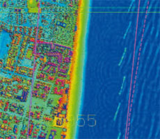
During the winter of 2004-2005, the ICC made a flight capturing data with the LIDAR laser altimeter, covering sheet 482 at 1:25,000 scale, with a scan density of 0.25 points/m2. Data was then processed and manually edited, obtaining the digital elevation models (terrain and surface).
The Instituto Geográfico Português and the Instituto Geográfico do Exército provided support for the project, capturing GPS data while the flight was made and taking topographic data inside the flight zone. When the work had been completed, the three parties drew up a technical report together.
Institut Cartogràfic de Catalunya (ICC); Instituto Geográfico Portugués (IGP), Lisbon, Portugal; Instituto Geográfico do Exército, Lisbon, Portugal.
Financed by: Undertaken jointly by the participating institutions.
Digital surface model and digital terrain model using LIDAR system (2004-2005)
Accomplishment, by part of the ICC, of a project to obtain the digital surface model and the digital terrain model of the coastal strip of the Emilia-Romagna region using laser altimeter.
Institut Cartogràfic de Catalunya (ICC); Regione Emilia-Romagna, Bologna, Italy.
Financed by: Emilia-Romagna Region.
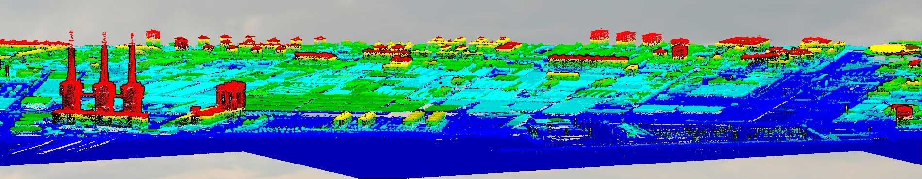
LIDAR campaign made in Germany (2003)
Conducted an aerial campaign with laser altimeter LIDAR, property of the ICC, in Hessen. It was carried out the flight plan and the acquisition of LIDAR data for the generation of the digital terrain model for approximately 35,000 hectares. The result of a LIDAR campaign is a cloud of points. In this case points were captured with a precision of 15 cm in altitude and 50 cm in planimetry flying at 1,000 meters above the surface.
Institut Cartogràfic de Catalunya (ICC); Infoterra GmbH.
Financed by: Infoterra GmbH.
LIDAR campaign made in Germany and Austria (2002)
Conducted an aerial campaign with laser altimeter LIDAR, property of the ICC, in Immenstadt, Kempten-Murnau and other zones of Germany close to lake Constance, and in Pulkau and Drau (Austria). It was carried out the flight plan and the acquisition of LIDAR data for the generation of the digital terrain model for approximately 25,000 hectares. The result of a LIDAR campaign is a cloud of points. In this case points were captured with a precision of 15 cm in altitude and 50 cm in planimetry flying at 1,000 meters a bove the surface.
Institut Cartogràfic de Catalunya (ICC); Infoterra GmbH.
Financed by: Infoterra GmbH.
Geometric calibration of the MOMS sensor (1996-2000)
The aim of this project was to adapt a geometric and radiometric deformation model of the MOMS02/PRIRODA sensor and to extract a terrain elevation model by means of the stereoscopic capacities of the sensor.
Institut Cartogràfic de Catalunya (ICC); Deutsche Forschungsanstalt für Luft- und Raumfahrt (DLR), Munich, Germany.
Financed by: Dirección General de Investigación Científica y Técnica, Madrid, Spain.
ORFEAS project (1995-1998)
Project approved within the 4th General Science and Technology Programme of the European Union. Its aim was to study the synergy of combining various territory evaluation techniques related with different sensors installed on satellites and aircraft. The contribution of the ICC included the study of how to extract the information describing the pattern of a set of SAR (Synthetic Aperture Radar) images of ERS-1/2 pairs acting in tándem. In this configuration, a satellite followed the same orbit as the other with a temporal displacement of one day. The interferometric with the stereographic techniques were combined, acting on a pair RADARSAT images, in order to obtain the best terrain elevations model.
Institut Cartogràfic de Catalunya (ICC); Aristotle University of Thessaloniki, Greece; Institut für Geodäsie und Photogrammetrie (Eidgenössische Technische Hochschule), Zurich, Switzerland; Institute of Computer Graphics, Graz, Austria; Politecnico di Milano, Italy.
Financed by: Subsecretaría de Minería de la Nación of the Secretaría de Industria, Comercio y Minería of the Government of Argentina, Buenos Aires, Argentina.
SAR interferometry, ERS-1 FRINGE (1994)
Participation of the ICC in the international working group on SAR (Synthetic Aperture Radar) interferometry, ERS-1 FRINGE, promoted and organized by the ESA, where a report on the first experiments with this technique by the ICC was presented. The ESA provided SAR images from the ERS-1 satellite with the aim of promoting the Development of interferometric techniques applied to the production of elevation models of the terrain. The project also promoted the study of differential interferometric techniques for the detection of small movements of the terrain (of the order of cm).
Institut Cartogràfic de Catalunya (ICC); European Space Agency (ESA), Frascati, Italy.
Financed by: European Space Agency (ESA).
