
 Contact


Cartographic symbology for a database of an oil company (2016)
At the request of The Sanborn Map Company Inc., the ICGC developed the cartographic symbology of all the operational areas of an oil company. For this project, all the geoinformation stored in the database of the oil company was analyzed to design a quality cartography. Subsequently, the symbology and its implementation in GIS software was designed. The symbology was designed for different scales and specific tools were developed to facilitate the work of the technicians and improve the production performance. It is worth highlighting the complexity of the design of the symbolism due to the hundred elements present in an oil operational area.
Institut Cartogràfic i Geològic de Catalunya (ICGC); The Sanborn Map Company Inc., USA.
Generalization of the topographic base 1: 5,000 of Andorra (2015)
Change of the reference system and the geodetic coordinate system of Andorra.
Institut Cartogràfic i Geològic de Catalunya (ICGC); Govern d’Andorra.
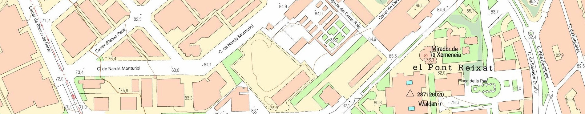
Updating of the topographic base of Andorra (2013)
Starting from the photogrammetric flight over Andorra (2012), to produce the orthophoto of this country, the ICC updated its topographic base at a scale of 1: 5,000. This process, in addition, will allow the future generalization to topographic cartographies of smaller scales. The specifications of this product were adapted to the Andorran geographical reality.
Institut Cartogràfic de Catalunya (ICC); Ministeri d’Economia i Territori (Govern d’Andorra).
Financed by: Ministeri d’Economia i Territori (Govern d’Andorra).
GIS4EU: Provision of interoperable datasets to open GI to the EU communities (2007-2009)
The ICC participated in the process of transposing the European directive INSPIRE, in the role of both regional supplier of information and collaborator in the design of a common information model, as well as in the process of establishing the mechanisms for transformation of its own data to facilitate joint exploitation with other European organizations.
Institut Cartogràfic de Catalunya (ICC); Consorzio per il Coordinamento delle Ricerche sul Sistema Lagunare di Venezia, Italy; Intergraph GmbH, Germany; Vyskummy ústav geodézie a kartografie v Bratislave, Slovakia; Universitat de Girona, Spain; Geographical Information Systems International Group, Italy; Földmérési és Távérzékelési Intézet, Hungary; Regione Liguria, Italy; Regine Piemonte, Italy; University of Nottingham, United Kingdom; Comune di Genova, Italy; Università di Roma La Sapienza, Italy; Intergraph Polska, Poland; Instituto Geográfico Portugués, Portugal; Instituto Nacional des Sciences Appliquées de Lyon, France; INSIEL Informatica per il Sistema degli Enti Locali Spa, Italy; CSI-Piemonte, Consorzio per il Sistema Informativo, Italy; Institut für Geoinformatik (Universität Münster), Germany; Intergraph Italia, Italy; Regione Veneto, Italy; Magistrato alle Acque di Venezia, Italy, Università IUAV di Venezia, Italy.
Financed by: Co-financed by the European Union.
IDE Univers (2007-2008)
The aim of this research project is to create a Spatial Data Infrastructure (SDI) that will promote access to the huge volume of geographic reference information produced by universities and research centers in the course of their projects and activities, facilitating the exchange and interoperability of this information.
Institut Cartogràfic de Catalunya (ICC); Istituto per il Rilevamento Elettromagnetico dell’Ambiente (CNRIREA), Milan, Italy; Instituto de Cartografía de Andalucía, Madrid, Spain; Regione Emilia-Romagna (Organizzazione, Sistemi Informativi e Telematica – Servizio Sistemi Informativi Geografici), Italy; University of the Aegean – Department of Geography, Greece. Led by Departament de Governació i Administracions Públiques.
Financed by: INTERREG IIIC MEDOC.
European Spatial Data Infrastructure (2007)
The IDEC (SDI of Catalonia) supported this infrastructure for the “State of Play” study, which analyzes the situation of European SDIs.
Institut Cartogràfic de Catalunya (ICC); SDIs European countries.
Financed by: Joint Research Centre (JRC) of the European Commission.
Geographic document management system of the Médina of Tunis (2003-2005)
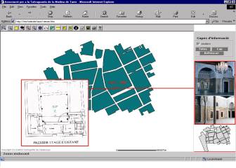
The project aim is to support the preservation of the architectural and cultural heritage of the historic center of the city of Tunis. The initiatives established in the program are: computerization of the cartography of the area to be protected and managed, through the incorporation of a geographic information system; computerization of the study office, through the provision of suitable computer equipment; computerization of the topographic archive of the association, through the introduction of a cartographic document management system; training of the ASM's staff in the use of computer equipment and applications, and deployment of a pilot project to validate the correct operation of the products developed.
Institut Cartogràfic de Catalunya (ICC); Agencia Española de Cooperación Internacional (AECI), Madrid, Spain; Association de Sauvegarde de la Médina (ASM), Tunisia.
Financed by: Agencia Española de Cooperación Internacional (AECI), Spain.
Cartographic database of Andorra 1:5 000 (2003-2005)
The aim of the project was to make the topographic map at 1:5,000 scale 3D of Andorra and surrounding areas, with a coverage of 64,750 ha, the orthophoto in colour at the same scale, with coverage of 78,750 ha, and the orthophoto in infrared colour with coverage of 64,750 ha. The project includes to make, with double camera, the flights in colour and in infrared colour at 1:20,000 scale, the topographic support, the scanning and the aerial triangulation of the flights, the photogrammetric stereoplotting and the edition of the topographic map and the generation of the two orthophoto coverage.
Institut Cartogràfic de Catalunya (ICC); Ministeri d'Ordenament Territorial (Govern d'Andorra).
Financed by: Ministeri d'Ordenament Territorial (Govern d'Andorra).
Cartography 1:500 3D of urban nuclei of Andorra (2001-2002)
The objective of the project is to make the official cartography at 1:500 scale 3D of Andorra. The project includes: plotting, field work and edition of 1,570 hectares.
Institut Cartogràfic de Catalunya (ICC); Ministeri d'Ordenament Territorial (Govern d'Andorra).
Financed by: Ministeri d'Ordenament Territorial (Govern d'Andorra).
Cartography 1:1,000 in 3D of the valley bottoms of Andorra (2001-2003)
The project includes plotting 1:1,000 in 3D, field work and edition of the valley bottoms of Andorra, exactly 2,760 hectares.
Institut Cartogràfic de Catalunya; Ministeri d'Ordenament Territorial (Govern d'Andorra).
Financed by: Ministeri d'Ordenament Territorial (Govern d'Andorra).
Urban cartography of Buenos Aires 1:500 (1996-1997)
The project consisted in the digital photogrammetric plotting, performed by the ICC, of 4,364 hectares of the city of Buenos Aires at 1:500 scale. The plotting was completed on the basis of a photogrammetric flight at 1:3,500 scale.
Institut Cartogràfic de Catalunya (ICC); CATRELSA, Buenos Aires, Argentina.
Financed by: Municipalidad de la Ciudad de Buenos Aires (MCBA), Argentina.
Land registry of Tierra del Fuego (1995-1996)
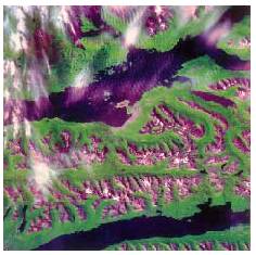
The aim of the project was to offer support in the execution of the urban and rustic land survey of the Argentinian province of Tierra del Fuego. Regarding the rustic survey, the foundation for the work was a mosaic of SPOT multispectral images. These images were captured in the course of two southern summers, but even so, the cloud cover was very high. Once the images were confirmed and orientated, a mosaic was made in which it was attempted to remove the clouds, producing a continuous virtual image. To complement the land registry, a land use interpretation of the province was completed, to be integrated with the other information extracted during the execution of the project.
Institut Cartogràfic de Catalunya (ICC); Informática Catastral y Medio Ambiente, Buenos Aires, Argentina.
Financed by: World Bank. International tender.
Galapagos Islands (1995)
The project consisted in a basic compilation of digital cartography of the Galapagos archipelago using Landsat-TM satellite images as a fundamental element for the implementation of a geographic information system. This geographical information system will have the benefit of all the information available to the institutions taking part.
Institut Cartogràfic de Catalunya (ICC); Instituto de Ingeniería, Caracas, Venezuela; Instituto Panamericano de Geografía e Historia, Quito, Ecuador; Instituto Geográfico Militar, Quito, Ecuador; Instituto Ecuatoriano Forestal y Áreas Naturales y Vida Silvestre, Quito, Ecuador; Estación Científica Charles Darwin, Galápagos Islands, Ecuador; Instituto Nacional Oceanográfico de la Armada, Quito, Ecuador; Instituto Geográfico Nacional (IGN), Madrid, Spain.
Financed by: Instituto Panamericano de Geografía e Historia.
