
 Contact

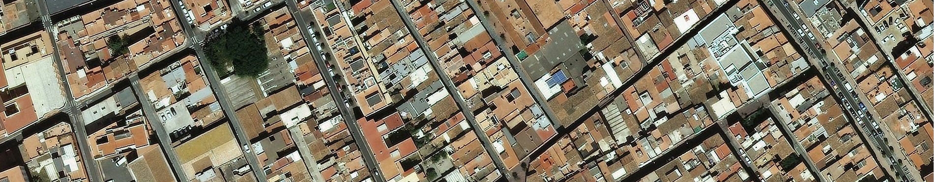


Orthophoto of Andorra and training of technicians (2012)
Photogrammetric flight over Andorra with a pixel size of 22.5 cm. Then, the field work was carried out and, subsequently, the aerial triangulation and the generation of the digital terrain model. The final product delivered was an orthophoto with a pixel size of 25 cm. On the other hand, within the framework of the same collaboration agreement, practical training was provided to two technicians of the Ministeri d’Economia i Territori, for eight weeks at the ICC headquarters.
Institut Cartogràfic de Catalunya (ICC); Ministeri d'Economia i Territori (Govern d'Andorra).
Financed by: Ministeri d'Economia i Territori (Govern d'Andorra).
Cartographic database of Andorra 1:5 000 (2003-2005)
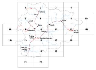
The aim of the project is to make the topographic map at 1:5,000 scale 3D of the Principality of Andorra and surrounding area, with a coverage of 64,750 ha, the orthophoto in color at the same scale, with coverage of 78,750 ha, and the orthophoto in infrared color with coverage of 64,750 ha. The project includes to make, with double camera, the flights in colour and in infrared colour at 1:20,000 scale, the topographic support, the scanning ant the aerial triangulation of the flights, the photogrammetric stereoplotting and the edition of the topographic map and the generation of the two orthophoto coverage.
Institut Cartogràfic de Catalunya (ICC); Ministeri d'Ordenament Territorial (Govern d'Andorra).
Financed by: Ministeri d'Ordenament Territorial (Govern d'Andorra).
Photogrammetric flights in colour of the valleys of the Principality of Andorra (2000)
The project consisted of two colour photogrametric flights at 1:3,500 and 1:5,000 scales with a focal of 300 mm; the topographic support; the scan in colour on CD-Rom of the necessary photograms for the digital aerial triangulation of the flights, and the digital aerial triangulation itself.
Institut Cartogràfic de Catalunya (ICC); Ministeri d'Ordenament Territorial (Govern d'Andorra).
Financed by: Ministeri d'Ordenament Territorial (Govern d'Andorra).
Satellite image map of Namibia at 1:2,000,000 scale (2000-2001)
The project adressed the acquisition and later geometric and radiometric correction of 50 Landsat-TM images that cover the totality with the territory of Namibia. Later the mosaic was undertaken, with the resulting image, and the publication of the map at 1:2,000,000 scale.
Institut Cartogràfic de Catalunya (ICC); Ministry of Agriculture, Water and Rural Development, Namibia; The National Planning Comission, Namibia; Agencia Española de Cooperación Internacional, Madrid, Spain.
Financed by: Agencia Española de Cooperación Internacional.
Orthophotomap of the Republic of Venezuela 1:25,000. PITSA-II (1998-1999)
The objective is to cover 121,009 km2 of the Venezuelan territory situated to the north of the River Orinoco, with 978 sheets at 1:25,000 scale. The orthophoto production process comprises the photogrammetric flight at 1:60,000 scale, geodetic control for the aerial triangulation and georeferencing with GPS instruments, and the use of a digital terrain model obtained by automatic correlation of images, which enables a digital orthophoto to be produced. The aim of this project is to include the territorial information collected about the Republic of Venezuela in the investment plan for the transformation of the agricultural sector (PITSA) of this country by means of a geographical information system.
Institut Cartogràfic de Catalunya (ICC); Ministerio de Agricultura y Cría (MAC), Caracas, Venezuela.
Financed by: Inter-American Bank of Development. International tender. World Bank.
Orthophotomap of the Republic of Venezuela 1:50,000. Radar images (CARTOSUR) (1998-1999)
The project consists to produce 534 digital radar orthoimages in black and white at 1:50,000 scale. A total area of 266,616 km2 is to be covered, corresponding to the states of Amazonas and Bolívar, to the south of the River Orinoco. The territorial information is captured and processed by means of an airborne radar system with a Synthetic opening and interferometric techniques are employed to produce the elevation models of the terrain and the contour lines. Through this project SAGECAN aims to acquire cartographic documentation for the inventory, control, evaluation and spatial siting of the natural resources of the area, to facilitate the monitoring and control of the plans, programmes and projects that the Venezuelan state is undertaking in the area, and to establish suitable support for the production of basic cartography of this territory at 1:50,000 scale.
Institut Cartogràfic de Catalunya (ICC); Servicio Autónomo de Geografía y Cartografía Nacional (SAGECAN), Caracas, Venezuela.
Financed by: Servicio Autónomo de Geografía y Cartografía Nacional (SAGECAN), Ministerio del Ambiente y de los Recursos Naturales Renovables, Caracas, Venezuela.
MAPTUTOR (1998-1999)
Elaboration of the CD-ROM designed to provide interactive tuition of the methodology and tools required for the production of image cartography based on satellite observation images. The recipient of this course will be the operators and users of the European Union Satellite Center. The contribution of the ICC will include the images that illustrate the process and the methodological observations that guide the work flow.
Institut Cartogràfic de Catalunya (ICC); International Institute for Aerospace Survey and Earth Sciences (ITC), The Netherlands.
Financed by: International Institute for Aerospace Survey and Earth Sciences (ITC), The Netherlands.
Orthoimage of the Republic of Venezuela 1:175,000. Caracas and surrounding area. Cartocentro (1997)
The project consisted in producing a synthetic orthoimage at 1:175,000 scale of the city of Caracas and the surrounding area. To achieve this, Landsat images were used which cover almost the entire area of the orthophotographic project in colour at 1:25,000 scale.
Institut Cartogràfic de Catalunya (ICC); Servicio Autónomo de Geografía y Cartografía Nacional (SAGECAN), Caracas, Venezuela.
Financed by: Servicio Autónomo de Geografía y Cartografía Nacional (SAGECAN), Ministerio del Ambiente y de los Recursos Naturales Renovables, Caracas, Venezuela.
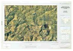
Topographic map and orthophotomap of Andorra 1:5,000 (1997-1998)
Obtaining of a base of three-dimensional numerical cartographic material covering the 64,752 hectares of Andorran territory and a strip of 50 metres from the border into the territory of the neighbouring states. To complement the project 74 orthophotomaps have been generated on the same scale, covering the entire area of Andorra, from a flight in colour at 1:16,000 scale.
Institut Cartogràfic de Catalunya (ICC); Ministeri d'Ordenament Territorial (Govern d'Andorra).
Financed by: Ministeri d'Ordenament Territorial (Govern d'Andorra).
Orthoimages of the Dominican Republic 1:50,000 (1997-2000)
The aim of this project is to produce various georeferenced products from SPOT and RADAR-SAT images of the territory of the Dominican Republic. More specifically, this will consist of orthorectified panchromatic SPOT coverage in black and white at 1:50,000 and 1:100,000 scales, radar coverage of the whole territory at 1:250,000 scale, and orthorectified multispectral coverage in colour of 12 sheets corresponding to the 1:50,000 series of the Dominican Republic.
Institut Cartogràfic de Catalunya (ICC); SPOT Image, Toulouse, France.
Financed by: SPOT Image, France.
Orthophotomap of the Republic of Venezuela 1:25,000 (1997-1999)
The aim of the project is to cover a total of 180,000 km2 of Venezuelan territory situated to the north of the River Orinoco (this includes the states of Barinas, Lata, Monagas, Portuguesa, Sucre, Yaracuy, Zulia and Guárico), and it forms part of the investment plan for the transformation of the agricultural sector, PITSA. It entails the production of a total of 1,500 sheets at 1:25,000 scale, created from a photogrammetric flight in black and white at 1:60,000 scale. In addition to the flight, the orthoimage production process includes geodetic support for the aerial triangulation and georeferencing with GPS instruments; furthermore, the subsequent use of a digital model obtained by automatic correlation of the images enables the production of a new continuous digital image with orthographic projection. The main aim behind the production of these georeferenced orthoimages is that they may be used in land registry applications by means of a geographical information system.
Institut Cartogràfic de Catalunya (ICC); Ministerio de Agricultura y Cría (MAC), Caracas, Venezuela.
Financed by: Inter-American Bank of Development. International tender. World Bank.
Pseudo-orthoimages of Mozambique 1:10,000 (1996-1997)
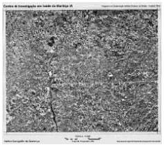
The aim of this project was to produce 6 pseudo-orthoimages in black and white at 1:10,000 scale of a small area of 16,800 hectares around a hospital in Mozambique, for the control of an exhaustive vaccination trial against malaria. The images were created with a view to their possible use in a geographical information system.
Institut Cartogràfic de Catalunya (ICC).
Financed by: Fundación Hospital Clínic, Barcelona, Spain; Agencia Española de Cooperación Internacional, Madrid, Spain.
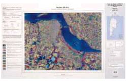
Orthophotomap of the Republic of Venezuela 1:50,000. Caracas and surrounding area (1995-1996)
The aim of the project was to produce an orthoimage of the area around the city of Caracas at 1:50,000 scale. To achieve this, sixteen colour orthophotographs at 1:25,000 scale that had been produced for the project of the SAGECAN were used. Once the digital images had been reduced in scale, each of them had to be linked up with the adjacent images in order to construct a mosaic without visible borders.
Institut Cartogràfic de Catalunya (ICC); Servicio Autónomo de Geografía y Cartografía Nacional (SAGECAN), Caracas, Venezuela.
Financed by: Servicio Autónomo de Geografía y Cartografía Nacional (SAGECAN), Ministerio del Ambiente y de los Recursos Naturales Renovables, Caracas, Venezuela.
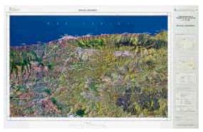
The Mediterranean Environmental landscape (1995-1996)
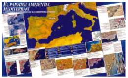
This study explored the environmental bases of the socio-economic functionality of the western Mediterranean area starting from the structure of its ecolandscape, working on the hypothesis that the socioecological landscape reflects both the history of human activity and the inherent potential of the territory. It consists of a map obtained by a mosaic of NOAA-AVHRR images of the western Mediterranean at 1:3,500,000 scale and of satellite images and orthophotographs on larger scales, which serve to illustrate climate and phenology, forest combustibility, the dynamics of the landscape conditioned by man, coastal towns and marine pollution, and division into plots and agricultural uses. There is also a technical report. The principal new feature is that satellite images are presented which offer a wide view of the condition of the area.
Institut Cartogràfic de Catalunya (ICC); Institut Català de la Mediterrània d’Estudis i Cooperació, Barcelona, Spain; Estudi Ramon Folch SL, Barcelona, Spain; MultiCriteria Consulting, Barcelona, Spain.
Financed by: Generalitat de Catalunya, Barcelona, Spain.
Satellite image of Argentina at 1:50,000, 1:100,000 and 1:250,000 scales (1994-1998)
The project consisted in the preparation of 717 sheets on different scales (1:50,000, 1:100,000 and 1:250,000) that cover a territory of 2,000,000 km2 based on satellite images, and the transfer of the technology necessary to produce this cartography. In order to complete this project, images from the Thematic Mapper (TM) sensor on Landsat-5 and panchromatic and multispectral sensors of the SPOT satellite were used. Support of the images has taken place in the field using GPS (Global Positioning System) systems. The elevations model necessary has been produced from existing cartography.
Institut Cartogràfic de Catalunya (ICC); Instituto Geográfico Militar de Argentina, Buenos Aires, Argentina.
Financed by: Instituto Geográfico Militar de Argentina, Ministerio de Defensa, Buenos Aires, Argentina; FAD loan on the framework in the General Treaty of Friendly and Cooperation between Argentinian Republic and Spain.
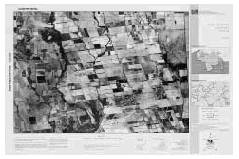
Orthophotograph of Holland 1:5,000 in B/W (1993)
The aim of the project was coverage with a black and white orthophotograph of a Dutch region at 1:5,000 scale. The starting-point for this project was a flight at 1:5,000 scale and the digital orthophotograph generation system of the ICC was used. To cover the study area, up to 32 images were needed, which were used to produce a virtual mosaic without overlaps, minimising the radiometric transitions between the components. Given the unusual characteristics of the project, it was necessary to develop new tools in the field of digital orthophotograph production.
Institut Cartogràfic de Catalunya (ICC); Rijkwaterstaat, Delft, The Netherlands.
Financed by: Rijkwaterstaat, Government of The Netherlands.
Completion of orthophotographic mapping of Venezuela (1993-1994)
The aim of the project was to transfer high technology in the form of digital orthophotomap material of the ICC to the SAGECAN, and to completing cartographic coverage with digital orthophotomaps at 1:25,000 scale of an area of 1,000,000 ha (93 sheets) around the city of Caracas. This project had the benefit of the information provided by a GPS (Global Positioning System) receiver installed on the aircraft, and this led to a considerable reduction in the need for field work to support the flight. Orthocartographic coverage was effected from colour photography.
Institut Cartogràfic de Catalunya (ICC); Servicio Autónomo de Geografía y Cartografía Nacional (SAGECAN), Caracas, Venezuela.
Financed by: Servicio Autónomo de Geografía y Cartografía Nacional (SAGECAN), Ministerio del Ambiente y de los Recursos Naturales Renovables, Caracas, Venezuela.
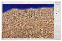
Mapping of the sources of the River Orinoco 1:100,000 (1992)
The project consisted in producing an orthoimage at 1:100,000 scale of an area of the Sierra de Parima, on the border between Venezuela and Brazil, where the sources of the River Orinoco are found. The document used as a starting-point was an image provided by the Thematic Mapper (TM) sensor on board of Landsat-5 satellite. The search for control points with the aim to orientate this image was carried out as part of the general tasks to extend the geodesic network of Venezuela to the borders of the country. Once the image had been orientated, it was geometrically and radiometrically corrected before being printed.
Institut Cartogràfic de Catalunya (ICC) and other participating institutions: Servicio Autónomo de Geografía y Cartografía Nacional (SAGECAN), Caracas, Venezuela; Committee of the Remote Sensing Applications of the Cartography Commission of the Instituto Panamericano de Geografía e Historia, Quito, Ecuador; Instituto Geográfico Nacional (IGN), Madrid, Spain.
Financed by: Servicio Autónomo de Geografía y Cartografía Nacional (SAGECAN), Ministerio del Ambiente y de los Recursos Naturales Renovables, Caracas, Venezuela.
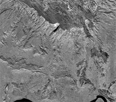
Orthoimage of the island of Livingston 1:100,000 (1991-1993)
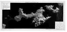
The aim of this project was to produce an orthoimage of the island of Livingston, where the Spanish base in Antarctica is situated. This work was completed within the framework of a collaborative agreement with the Departament de Geomorfologia of the Universitat de Barcelona. Project stages: production of an image from Thematic Mapper (TM) data provided by the Landsat-5 satellite; analysis of the SPOT stereoscopic images taken over the island, in order to obtain the numerical model of elevations and subsequently an orthoimage; production and publication of the map of the island on a scale of 1:100,000 from SPOT images; production of an animated sequence of two minutes and thirty seconds simulating a flight over the island, using the orthoimage 1:100,000 and the numerical model of elevations as a source of information.
Institut Cartogràfic de Catalunya (ICC) and other participating institutions: Departament de Geomorfologia (Facultat de Geologia, Universitat de Barcelona), Barcelona, Spain.
Financed by: Comisión Interministerial de Ciencia y Tecnología, Madrid, Spain.
