1.2. Avalanche Database (BDAC) and Avalanche Paths Map (MZA)
We can summarise the main differences between the BDAC and the MZA in four points:
- Type of information: The MZA contains graphic information. The BDAC contains all of the associated alpha-numeric information.
- Cartographic concepts:
The MZA has two: avalanche path determined according to the characteristics of the terrain and the effects of avalanches mainly on vegetation, and the avalanche path determined according to the area population survey.
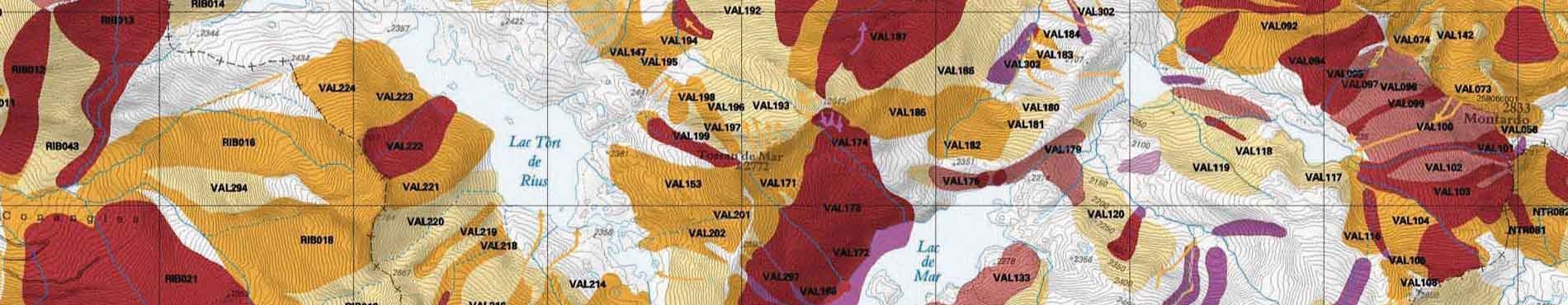
The BDAC has three cartographic concepts: Avalanche Path, Avalanche Survey and Avalanche Observation. - Scale: The MZA is published with a scale of 1:25 000 Information on the BDAC is represented on the ICGC's scale of 1:5.000.
- Update: The MZA is updated when a new edition of the map is published. The BDAC is continuously updated.
1.3. BDAC in figures
Dated June 2007, the quantification of the information gathered during the preparation of the avalanche maps can be represented by the following figures:
- 5.092 km2: mapped area.
- 1.257 km2: mapped area susceptible to avalanches.
- 17.518 avalanche paths.
- 2.832 avalanche surveys.
- 3.559 avalanche observations.
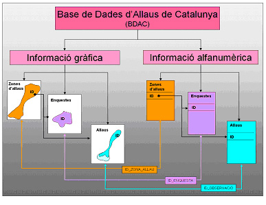
1.4. Structure of the BDAC
BDAC is a relational database that allows:
- Any type of information gathered to be recorded (AZ, AS, AO).
- The existing hierarchy between different information to be reflected.
- Any duplicated information to be eliminated.
- The analysis, both statistical and spatial, of the phenomena based on the information stored.
The stored information is graphic and alpha-numeric; attributes describing the physical characteristics of the represented element correspond to each polygon represented on the map.
How BDAC was created?
2.1. Why this information is gathered
The information is gathered to create a knowledge bank that allows future catastrophes to be prevented.
2.2. Stages of the development of BDAC
The information stored on BDAC has been obtained in the following way:
2.2.1. Photo-interpretation and verification in the field.
Based on the characteristics of the terrain -height above sea level, slope, orientation, roughness, morphology-, and signs left by the path of avalanches, above all in forests, the areas susceptible to generating and being affected by avalanches are delimited. Using aerial photographs and orthophotos taken in the summer, these effects are discovered. With the help of digital elevation models, slopes that could trigger an avalanche are revealed. Verification of these effects is subsequently made in the field.
Avalanche Database of Catalonia (BDAC)
Graphic information, Alpha-numeric information, Avalanche zones, Surveys Avalanches
2.2.2. Survey:
A survey is carried out in the field, preferably with the older generation, to gather information about avalanches in the past, of which it is difficult to find traces today. This survey is also carried out on people who work in the mountains. The information obtained is contrasted with the information obtained during stage one.
2.2.3. Winter monitoring:
Since the 1986/7 season, but particularly as of the largest incidents during the 1995/6 season, avalanche activity has been monitored and mapped. The network of observers in Catalonia -formed by ski resorts, mountain refuge keepers, countryside wardens and nivologists-, technicians from the Conselh Generau d'Aran (General Council of Aran) and the Meteorological Service of Catalonia, the Fire Brigades of the Generalitat de Catalunya and Aran, together with technicians from the Cartographic and Geological Institute of Catalonia, are responsible for this task. Information is also received from people who send us their observations.
Structure of the contents of BDAC
The information on BDAC is structured based on three mapping concepts:
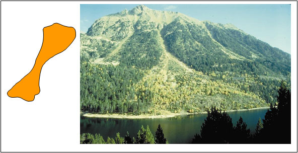
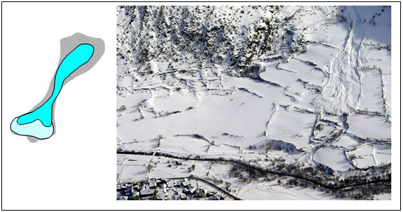
Avalanche Path (AP): Information regarding an area exposed to avalanches, resulting from the analysis of the terrain and of the signs that avalanches leave in their path, mainly with regard to vegetation.
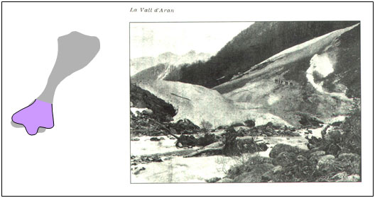
Avalanche Survey (AS): Information regarding an avalanche observed, resulting from a survey of inhabitants of the area where the phenomenon took place.
Avalanche Observation (AO): Information regarding an avalanche observed, resulting from the direct mapping of the incident.
The APs represent the terrain susceptible to the triggering of an avalanche and its path, whilst the ASs and the AOs represent avalanches that have occurred. The difference between AS and AO is in the quantity and precision of the information. The former contains descriptions that are in general fairly imprecise, mainly of the runout zone of the avalanche, above all located in inhabited areas. Their value lies in the fact that they document significant incidents that occurred mainly during the last century. In the case of AOs, they normally describe the entire avalanche, and the data gathered is more extent in the region and more precise, but documented events only exist for the last 20 years. Therefore, the APs allow us to analyse the avalanche terrain throughout the region, whilst the ASs and AOs help, on one hand, to fine tune the mapping criteria used, and on the other, to analyse the characteristics of recorded avalanches.
Usefulness of the BDAC
The information stored on the BDAC is essential for any study on hazard and risk. The BDAC meets the objective of providing an efficient tool for the management, analysis and update of the data.
The BDAC is not only an application that enables users to consult and download information and basic analyses, through Geoindex -viewer and WMS geoservices- but also allows new data to be included in their projects. This leads to an efficient update of the database and contributes to the knowledge of the phenomena of avalanches in the Pyrenees.
Bibliography related to the network
Marturià, J.; Oller, P.; Martínez, P. (2006): La Base de Dades d'Allaus de Catalunya. Actes de la 2a Jornada Tècnica de Neu i Allaus. Barcelona, 26 i 27 de Juny de 2006. p. 87-91.
Oller, P.; Marturià, J.; González, J.C.; Escriu, J.; Martínez, P (2005): El servidor de datos de aludes de Cataluña, una herramienta de ayuda a la planificación territorial. In proceedings of: VI Simposio Nacional sobre Taludes y Laderas Inestables. Alonso, J. Corominas, L. Jordà, M. Romana, J.B. Serón (Eds.). Valencia, 21-24 de Junio de 2005. p. 905-916.
Oller, P.; Marturià, J.; González, J.C.; Muntan, E.; Martínez, P. (2004): La cartografia d'allaus i la seva aplicació en la prevenció del risc. I Jornada Tècnica de Neu i Allaus. Barcelona, 16 de juny de 2004. p. 16-20.
Oller, P.; Muntán, E.; Marturià, J.; García, C.; García, A.; Martínez, P. (2006): The avalanche data in the Catalan Pyrenees. 20 years of avalanche mapping. Proceedings of the International Snow Science Workshop. Telluride, Colorado (USA). October 1-6, 2006. p. 305-313.

 Contact