Alternatives
Subsidence can be monitored through classical geotechnical observations, consisting of the installation of sensors that measure the vertical deformations of the terrain, or through high-precision topographic leveling. These techniques, however, are limited to very specific areas with known or foreseeable subsidence (mining, karst areas ...), and the evolution is only visible with the passage of time (not enough historical record is available).
Other techniques to detect subsidence use radars embedded in satellites, in such a way that large areas of land (up to 10,000 km2) can be covered, and at the same time reduce costs in relation to classical methods, since relatively cheap images are used. In addition, there is a high availability so that the radar is not affected by clouds, nor by meteorology (except with very intense rains), nor does it require lighting (it can work day and night).
These techniques, called DInSAR (differential interferometry), are based on the combination of two radar images, and measure the millimeter deformations that have occurred between the dates of both images. Unfortunately, as the atmospheric conditions vary in each acquisition, artifacts that hide deformations can arise.
To overcome this limitation, the ICGC uses its own techniques of advanced DInSAR, based on the use of a set of images (instead of just two), acquired on different dates (there are historical ones since 1992), and thus makes it possible to calculate a temporary deformation profile in the study area.
In certain areas, such as significant vegetation or water, the movement cannot be calculated, so the ICGC detects them and isolates them from the final result. On the other hand, different types of radar images can be selected depending on the study area and the type of movement to be observed, thus maximizing the useful areas.
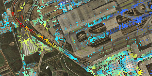
After the subsidence detection, it is possible to do an exhaustive follow-up by means of the programmed acquisition of new images. The result is a map of the movement of the land, being necessary to add complementary knowledge, such as geological information or data on the structure of buildings and terrain, if it is necessary to do a risk analysis (infrastructure, building, civil protection ... )..
Solution description
If the need is to detect possible movements given up to the present, we start with several radar images from Earth observation satellites, corresponding to different dates to be able to observe the deformations over time.
If you want to monitor a detected subsidence, or if it is expected that there may be movements due to anthropic actions (public works, intensive water extraction...), the acquisition of radar images will be programmed for this purpose to obtain results with the necessary frequency.
In both cases, the result is a layer with the vertical deformations of the terrain, compatible with a GIS, in such a way that it can be combined with other layers (orthophotos, topography, geology, infrastructures, cadastre...) and obtain information for the risk assessment by interpreting the results..
Articles
- R. Arbiol et al., Photogrammetric Engineering & Remote Sensing, 2003.
- P. Blanco et al., 2010.
Realized projects
- Annual monitoring of subsidence in Catalonia.
- Subsidence analysis in Bages, in the Ebro delta, in the Catalan potassium basin, in Bogotá (Colombia), Puebla de Zaragoza (Mexico), in the volcano of Popocatépetl (Mexico), and effects of the earthquake of Al-Hoceima (Morocco).
Related aplications
- Radar mapping (in areas of high cloudiness).
- MDT of large areas.

 Contact