
 Contact


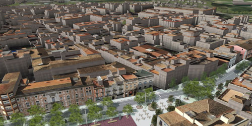
In the 3D City models, the ICGC combines photogrammetric flight and LiDAR, with tachymetry and photography in areas of occultation
In addition to recreational and commercial visualization (navigation, tourism, public communication, etc.), 3D models of cities allow technical analysis in areas such as:
- telecommunications, for the distribution of mobile phone antennas where they generate greater coverage,
- electricity, when placing solar panels and optimizing public lighting,
- the environment, to model noise and light pollution,
- territorial planning and architecture,
- the management of underground structures and elements,
- the preservation of monuments,
- risk prevention and civil protection.
Precisely most of these applications require high precision and completeness, and additionally alphanumeric information on the elements included (material, owner ...). Consequently, rather than using a simple graphical representation, what is really necessary are precise 3D data, with an optimal data model and quality georeferencing.
In fact, several levels of detail (LOD, from the English Level Of Detail) can be distinguished, usually classified between LOD0 and LOD4, although in 3D city models we work between LOD1 and LOD3. In any case, the final application will indicate what to use: in some cases a simple representation with rectangular blocks is sufficient, but in others more complex details are required.
Alternatives
The most widespread solution to generate 3D models of cities, with a medium level of detail, consists of carrying out photogrammetric flights and restitution (generation of 3D data), improved with automatic correlation techniques. In addition, this solution directly provides the images to give texture to the model, even of facades if a large number of photographs are obtained or if they are taken obliquely, but the process time required is quite high.
Another solution that is easier to automate is to use LiDAR, making it possible to directly extract buildings (we work with 3D points) to generate the model. Unfortunately it does not provide the images to apply textures, but in many applications these are optional.
Similar to LiDAR, radar could also be used, taking into account that it covers more territory at once but with less precision, that is, recommended when the refresh rate is a priority.
The most complete solution, then, would go through a combination of photogrammetric flight and LiDAR, including the processes that characterize both methods.
In any case, a highly detailed model requires tachymetry and photography at street level, although it is also recommended in areas of concealment (narrow streets, large terraces ...)..
Solution description
Although the ICGC can use the method that best suits each approach, it usually opts for the combined solution, taking advantage of the same flight to obtain photographs and LiDAR points.
Apart from obtaining data, it is also possible to adapt the structure of the model, an important aspect in applications that go beyond simple visualization.
The ICGC has mechanisms that automate a good part of the photogrammetric processes, including georeferencing, image processing, correlation, and application of textures. In fact, some of the algorithms have been custom developed by the ICGC itself.
Regarding LiDAR, the ICGC knows in depth the requirements to obtain the expected results, and applies processes that automate both the extraction of buildings and the previous georeferencing and classification of points.
In all cases, automatic processes are always accompanied by manual reviews and obtaining statistical reports. Obviously, a precision product requires a thorough quality control.
It is worth highlighting the study that the ICGC has carried out in relation to 3D models of cities, allowing the selection of formats (GML3, CityGML, DAE ...), data structures, software, etc., depending on the needs that arise..
Fulfilled projects
- Gray 3D buildings in Google Earth.
- Vilafranca del Penedès model; Barcelona Media
- Riudoms model; Virtuelcity
Related applications
- Strict ortophoto
- Light polllution
- Energy efficiency of buildings
