Data
The density of seismic stations and the quality of the records are variable during the period 1977-1997, which causes a certain heterogeneity of the data.
Since 1977 to 1985, the number of the stations is scarce, the epicentral locations present a low accuracy (about 10 km) and a raw control of the depth. For this period, hypocentral locations from the Servei Geològic de Catalunya (SGC) and the Laboratoire de Detection et de Geóphysique (LDG, 1977-1985) have been considered.
From 1986 to 1997, the desnity of the seismic network gets higher and the distance between stations decreases until 30 km. Additionally, other stations from different institutions are used for the computation of the hypocentral location (SGC, 1986-1997; SGC/OMPT, 1990-1996).
In reference to the magnitude, for the period 1977-1985, the values are taken from the LDG magnitude. From 1986 to 1989, the duration magnitude fitted to the LDG has been computed. Between 1990 and 1996, the computed magnitude from OMPT is assumed and in 1997, the same is done with the Richter magnitude.
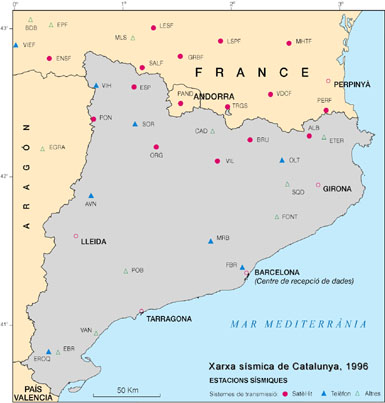
Seismic network of Catalonia
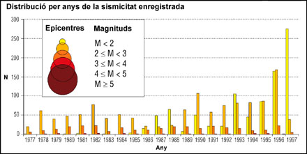
Histograma dels sismes localitzats a la xarxa sísmica de Catalunya
Seismicity map
The seismicity is overlaying different digital bases of the ICC:
- Shaded relief from the 15x15m spacing DEM of Catalonia;
- Tectonic features from the Geologic Map of Catalunya 1:250.000 scale. The age of the faults have been considered in function of the recognised neotectonic evidences on the field (Plioquaternary and Pre-Plioquaternary). The major structural units and the Neogene basins is also indicated;
- Bathymetry, from the cartographies of the Instituto Hidrográfico de la Marina;
- Faults in the continental platform, from the Instituto Tecnológico GeoMinero de España.
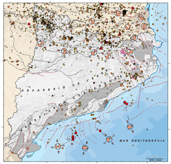
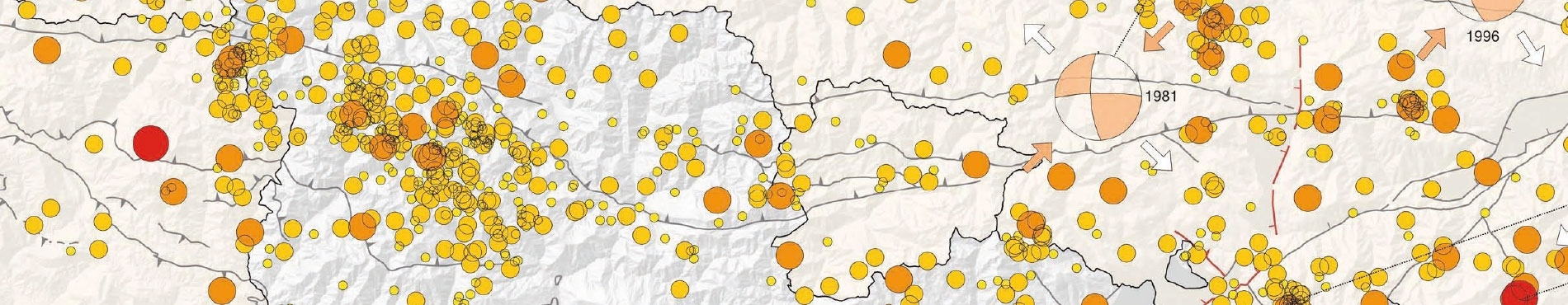
1977-1997 Seismicity Map of Catalonia
Comments
The following aspects can be considered:
- - The major seismic activity is concentrated in the Pyrenees and the Mediterranean areas; in the Ebro basin the seismic activity is low according to its scarce tectonic deformation.
- Despite the density of the seismic stations, for the events located in the Mediterranean system (Catalan coastal ranges and Continental platform), the azimuthal coverage until now is incomplete and the locations of the earthquakes are less accurate respect to those of the Pyrenees area. Although the level activity in the Mediterranean system is minor that in the Pyrenees, 7 of the 11 events of magnitude greater than 4 have occurred in the period 1986-1997, mainly offshore.
- The earthquakes in the Pyrenees are concentrated in the Axial zone. The major earthquake during this period, 5.2 magnitude, took place in 1996 in the Eastern Pyrenees (West of Perpignan).
- The greater part of the focal mechanisms of the Pyrenees area point out the presence of the strike-slip faults compatible with a compressive regime of N-S orientation. Three of them, located in the northern part of the Axial zone (1978, 1981 and 1996) present a pressure axe of NE-SW orientation, meanwhile the rest present a NW-SE orientation. The focal mechanisms located in the continental platform present a compressive regime, with a certain variability of the pressure axe of the orientation between NNW to NNE.
- Finally, it is noticeable the coincidence between the location of earthquakes and neotectonic indicators, a clear case is the Neogene basin of La Selva. Nevertheless, it can not be said that there is a clear link between seismicity and Plioquaternary faults.
References
- LDG (1977-1985): "Epicenter database". Computer file.
- SGC (1986-1997): "Butlletí Sismològic. Generalitat de Catalunya. Servei Geològic de Catalunya".
- SGC (1989): "Mapa Geològic de Catalunya escala 1:250.000". Generalitat de Catalunya.
- SGC/OMPT (1990-1996): "Seismic activity in the Pyrenees. Annual bulletin". Servei Geològic de Catalunya and Observatoire Midi-Pyrénées de Toulouse.
- Goula, X.; Olivera, C.; Fleta, J.; Grellet, B.; Lindo, R.; Rivera, L.A.; Cisternas, A. and D. Carbon (1999): "Present and recent stress regime in the Eastern part of the Pyrenees". Tectonophysics, 308, 487-502.

 Contact