• Imprimeix

Map of Hydrogeological Areas of Catalonia 1:250,000 (MAH250M v1.0, 2017)

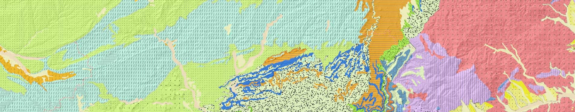
The Map of Hydrogeological Areas of Catalonia 1:250,000 (MAH250M v1.0, 2017) is a support tool for the representation and dissemination of territorial and subsoil hydrogeological features. It is a synthesis on a 1:250,000 scale of the hydrogeological macro-units into which land area may be divided (termed hydrogeological areas) and includes the listing of the geological formations distinguished in the Geological map of Catalonia 1:250,000 identified as hydrogeological formations, bearing in mind their lithology.

On November 2022, the download formats have been updated to include the "qml" symbolization compatible with the open-source QGIS software.


SHAPE format

The ZIP file that is downloaded includes the following files:

  • arees-hidrogeologiques-v1r0-sectors-2022: Hydrogeologicalsectors (polygons).
    Contains the following fields:
    • CODI_CAS: Unique code that identifies the object.
    • SECTOR: Hydrogeologicalsector.
    • DESCRIP: Hydrogeologicalsector description.
  • arees-hidrogeologiques-v1r0-arees-2022: Hydrogeological area (polygons).
    Contains the following fields:
    • CODI_CAS: Unique code that identifies the object.
    • CODI_AH: Hydrogeological area code.
    • NOM_AH: Hydrogeological area name.
    • SECTOR: Hydrogeological sector.
  • arees-hidrogeologiques-v1r0-limits-arees-2022: Hydrogeological area boundaries (lines).
    Contains the following fields:
    • CODI_CAS: Unique code that identifies the object.
    • TIPUS_LIM: Hydrogeological area boundaries type.
    • DESC_LAH: Hydrogeological area boundaries type description.
  • arees-hidrogeologiques-v1r0-formacions-2022: Hydrogeological formation (polygons).
    Contains the following fields:
    • CODI_CAS: Unique code that identifies the object.
    • CODI_GFH: Hydrogeological formation group code.
    • GRUP_FH: Hydrogeological formation group name.
    • CODI_FH: Hydrogeological formation code.
    • DESCRIP_FH: Hydrogeological formation name.
    • MGC250M: 1:250.000 geological map epigraph.
  • arees-hidrogeologiques-v1r0-naturalesa-aquifers-2022: Aquifer media according to lithology (polygons).
    Contains the following fields:
    • CODI_CAS: Unique code that identifies the object.
    • CODI_GTAQ: Predominant aquifer media group code.
    • NOM_GTAQ: Predominant aquifer media group name.
    • CODI_TAQ: Predominant aquifer media code.
    • NOM_TAQ: Predominant aquifer media name.

It is included the Layerfile (.lyr) for ArcGIS/ArcMap Desktop v10.0 (ESRI) and Layerfile (.lyrx) for ArcGIS Pro symbolization files for each of the datasets and the "qml" symbolization files for each of the datasets supported by the open-source QGIS software.

The reference system of the distributed data is ETRS89.

WMS Hydrogeological cartography

This geoinformation can be used online in your applications supporting the WMS protocol

SHP data

Download digital cartography in SHP format and symbolization for ArcGIS and QGIS [ZIP, 42 MB]

Content description report

Download [Catalan, PDF, 1 MB]

Metadata

Metadata access


Details

The map’s first edition was published in 1992 by the Geological Institute of Catalonia (Planning and Public Works). Twenty four years later, this map has a strong claim to remaining a reference; on the one hand, by providing the synthesis and presentation of the area's hydrogeological context, and on the other hand, by providing feasibility studies and inputs to regional planning.

The Map of Hydrogeological Areas of Catalonia 1:250,000 (MAH250M v1.0, 2017) is a revised and updated version of the map published in 1992. This update was undertaken by the ICGC with the collaboration of the Catalan Water Agency (ACA).

This version responds to a new distribution data model and incorporates several improvements of both attributes and geometries as the updated version (2016) of the Geological map of Catalonia 1:250.000, has been used as basic information.

MAH250M information is organized into five groups of objects: hydrogeological sectors, hydrogeological areas, hydrogeological area boundaries type, hydrogeological formations and aquifer media according to lithology.

Each group of hydrogeological objects mainly corresponds to 3D bodies or surfaces. In the distributed files (2D shapes) these objects are represented according to the geometry associated with shape types (polygons, lines and points).

Hydrogeological sectors

Four large groups of hydrogeological areas are represented: first sector of Pyrenean areas (code 100), second sector of central areas (code 200), third sector of coastal areas (code 300) and fourth sector of fluviodeltaic coastal areas (code 400).

Hydrogeological areas

They are structural entities (tectonic or sedimentary) with a certain entity in their lithological characteristics and, therefore, in their aquifer characteristics.

Hydrogeological area boundary type

Three main types of hydrogeological area boundaries are represented: administrative, hydrographic and geological boundaries (structural or sedimentary).

Hydrogeological formations

Using lithological and chronological criteria, the geological formations represented in the MGC250M are classified into 27 hydrogeological formations grouped into 9 types: hydrogeological formations of gravels, quaternary sand and silts, hydrogeological formations of massive conglomerates and sandstones, hydrogeological formations of limestones and massive dolomites, hydrogeological formations of limestones and lacustrine detrital deposits, hydrogeological formations of conglomerates, sandstones and marls of Paleogene, hydrogeological formations of marls and evaporites of Paleogene, hydrogeological formations of Palaeozoic sandstones, slates and schists, hydrogeological formations in granite formations and mixed hydrogeological formations in Neogene depressions.

Aquifer media according to lithology

Classification and distribution of surface aquifers according to their porosity and consolidation conditions are represented and grouped into 4 types: non-consolidated (or semi consolidated) porous aquifers, consolidated aquifers, low permeability zones with local aquifers, volcanic aquifers with intergranular permeability and/or by fracturing.