
 Contact


There are determinate areas in Catalonia that are exposed to a greater probability of living seismic emergency situations. The studies that they carry to the identification of these zones it is evident fundamentally of two parts:
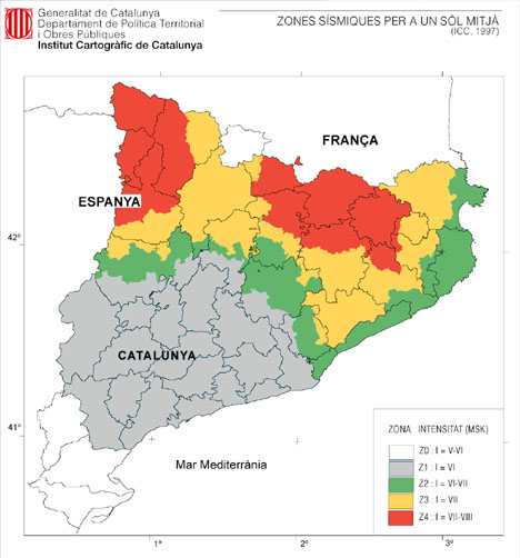
- The assessment of the seismic dangerousness, an estimation of the intensity of the seismic movement in each town of Catalonia and the result is the map of seismic zones.
- The assessment of the seismic vulnerability of the constructions in all the Catalan territory, which makes an estimation of the damages that a seismic movement can cause on the towns of Catalonia. Constructions such like houses and other uses for the people, in which the indispensable services for the community rest due to its activities, in the event of an earthquake they can make bigger damages from associated catastrophic effects.
The combination of these two studies makes possible a risk scenario for each town of Catalonia.
The map of seismic zones has been based in the probabilistic map modified partially by the results of the deterministic map in the places where the difference of intensity between both maps is important. This map is related on a ground of medium type, that according to the used geotechnic classification, it corresponds on a ground of type A (45% of the towns).
The probabilistic evaluation of the seismic dangerousness has been carried out with a zoned model. The process to make these models can be summarized in the following way:
- The characteristic parameters of the model of earthquake occurrence are adjusted in every seismotectonic zone, using the data of the catalog.
- One time have been deduced all the distributions of probability of occurrence of earthquakes for each seismotectonic zone, the effects of the seismicity of each zone are propagated in each point of the territory, in accordance with some laws of attenuation of the seismic intensity with the distance, adjusted for Catalonia.
- The seismic effects coming from each seismotectonic zone are studied in each of the points of Catalonia, and the likelihood of exceeding a determinate intensity in a period of given time is calculated, in this case 500 years.
The deterministic map está representado por la intensidad máxima percibida en cada punto de Catalunya como consecuencia de los terremotos conocidos desde el siglo XIII.
The estimation of this intensity in each point of Catalonia has been obtained applying a model of attenuation of the intensity with the distance to each seism of the catalog. In this way, in each point of Catalonia, the intensity that probably was perceived can be known for all of the earthquakes of the catalog. With the consideration of the effects of all these seisms the maximum intensity can be deduced in each point.
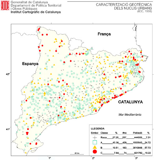
For taking the amplification of the seismic movement due to the soft grounds into account, the geology of each of the 944 towns of Catalonia has been studied and a geotechnical classification of all them using 4 typology of grounds has been carried out.
A geotechnical classification is proposed according to four types of grounds R, A, B and C, with a particular answer in forehead of the seismic phenomenon.
This classification of grounds is associated with the speed that the waves S have on crossing them.
- The ground type R corresponds to a hard rock.
- The type A correspond in compact rocks.
- The type B in semi-compacted materials.
- As last, type C corresponds to uncohesionical materials.
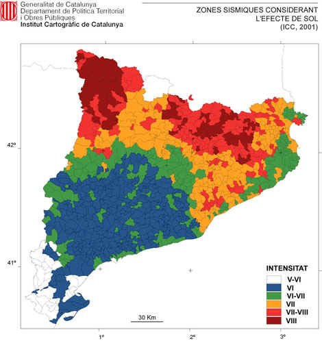
The site amplification has only been considered urban nucleous of municipalities, since the geotechnical classification has been carried out only for the urban nucleous of the towns. To take the possible amplifications produced for soft grounds, type B and C, and in accordance with similar studies carried out in other places into account, an increase of the intensity has been considered for each of the 4 types of ground established.
The amplifications proposed to the urban kernels with respect to the intensity of the map of seismic zones are the following ones:
- Type R : any degree of intensity is added up to it.
- Type A : any degree of intensity is added up to it.
- Type B : 0.5 degrees of intensity are added up to the intensity of the map of seismic zones.
- Type C : 0.5 degrees of intensity are added up to the intensity of the map of seismic zones.
The map of seismic zones which it results from considering the site amplification is next shown:
Due to the moderate seismicity of the region, the seismic vulnerability of the current buildings has not been put on trial by any important earthquake. An estimation of the seismic vulnerability of the park of buildings existing in Catalonia has been able to be made, by similarity with constructions of known vulnerability, and from the knowledge of the constructive techniques of the country.
The result of this classification has allowed to establish the distribution of the buildings of each town in classes of vulnerability A, B, C and D (classification EMS'92). Each town has been cataloged of high vulnerability (25 towns), average (569 towns) or casualty (347 towns).
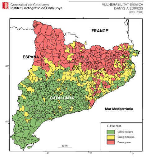
From the classification of the buildings in classes of vulnerability, a general evaluation of the damages that could be observed in each town of Catalonia, considering the intensity foreseen in the map of seismic zones and the effect of the ground, has been carried out.
The evaluation of the damages of the buildings has been carried out from matrices of likelihood of damages, obtained from Italy from the observations of recent earthquakes. As a result of the evaluation of the physical damage, the number of buildings is obtained from each town distributed according to the different degrees of damages. As a synthesis of the obtained results, a classification of the towns has been made according to the distribution of the different degrees of damage, with the goal to show a global vision of the ruin for towns. In this order, three groups of towns have been gauged according to the degree of damage: slight, moderate and severe.
In short, they consider themselves those that would have more in 40% of its buildings with moderate or severe damages like towns seriously damaged; moderately damaged those that they would have of 20% in 40% of its buildings with moderate or severe damage and slightly damaged those that would have less of 20% of these categories.
In the following figure the result is shown of applying this procedure. In this map a great concentration of the towns observes seriously itself damaged in the north part of the region, which arrives about 25% from the towns of Catalonia; the contrary to this situation is presented in the south part, where the slight damages are located, observed to the senior number of towns, corresponding almost to 50% of the total. To the central portion of the region, in 25% of the rest of towns, the moderate damages are found.
It is necessary to point out that the map does not correspond to l stage of a possible earthquake alone sino to the estimations made by the values of intensity assigned in the former map of seismic zones.
Also an appraisal of the physical damages to the persons and an economic estimation of the physical damage in the buildings of house have been carried out.
These results incorporate into the Plan of Seismic Emergency of Catalonia (SISMICAT) that has prepared the Ministry of Inland, in order to gauge which towns they have that to carry out the plan of municipal emergency in forehead of earthquakes. The Plan has been standardized by the Comisión Nacional de Protección Civil in the month of June of 2002.
