



i-DEAL
Geospatial technologies for Green Deal and climate change mitigation
The i-DEAL (Geospatial Technologies for Green Deal and Climate Change Mitigation) project aims to boost new capacities and strengthen technical talent and skills in the field of geomatics and Earth observation through an exchange programme of research and technical staff between European institutions.
The project will develop and validate new approaches for the acquisition, processing, verification and use of geospatial data aimed at supporting European Green Deal actions and climate change adaptation and mitigation measures. To do this, innovative technologies such as artificial intelligence, robotics, oblique aerial cameras, LiDAR and hyperspectral sensors will be combined, integrating ground, aerial and satellite data for the monitoring of different ecosystems.
Specific objectives
- To promote mobility and knowledge exchange between European research centres, universities and public bodies.
- Develop new methodologies based on advanced geospatial technologies to support European Green Deal policies.
- Apply artificial intelligence and Earth observation tools to environmental monitoring, diagnosis and predictability of climate impacts on the territory.
- Improve ecosystem management and resilience through innovative geospatial services.
- Promote sustainable research practices aligned with the Sustainable Development Goals (SDGs).
Visual identity of the i-DEAL project, which promotes the application of advanced geospatial technologies to support the European Green Deal and climate change mitigation.
The consortium
The project is coordinated by Fondazione Bruno Kessler (FBK) and brings together academic institutions, research centres and European public bodies specialised in geospatial technologies, Earth observation and climate change.
- Fondazione Bruno Kessler (FBK, Italy) - Coordinator
- Technische Universität Wien (TUW, Austria)
- University of Warsaw (UW, Poland)
- Ukrainian National Forestry University (UNFU, Ukraine)
- Finnish Geospatial Research Institute (FGI, Finland)
- Bureau de Recherches Géologiques et Minières (BRGM, France)
- Norwegian Institute of Bioeconomy Research (NIBIO, Norway)
- Institut Cartogràfic i Geològic de Catalunya (ICGC, Catalonia)
- Czech Office for Surveying, Mapping and Cadastre (Czech Republic)
- AVT Airborne Sensing Italia (Italy)
- AVT Airborne Sensing Austria (Austria)
The ICGC actively participates in the project through exchanges of research and technical staff, leading a work package dedicated to geospatial services for resilient ecosystems.
i-DEAL at a glance
- Title: Geospatial Technologies for Green Deal and Climate Change Mitigation (i-DEAL)
- Total budget: 946.890 €
- ICGC budget: 75.150 €
- Start date: January 1, 2026
- Expected end date: December 31, 2029
- Coordination: Fondazione Bruno Kessler (FBK)
- Web: https://ideal.fbk.eu/
- Programme: Horizon Europe - Marie Skłodowska-Curie Actions (MSCA) Staff Exchanges
- Call: HORIZON-MSCA-2023-SE-01
- Reference: 101236355
Impact of the project
The project will contribute to the training of a new generation of specialists in geospatial technologies applied to environmental and climate sustainability. The results will advance the development of innovative geospatial services for ecosystem monitoring and climate change-related decision-making, thus strengthening the contribution of geospatial data to European environmental policies.
In addition, i-DEAL will promote knowledge transfer between European institutions and encourage the incorporation of environmentally sustainable research practices into R+D activities.
Structure of the project
I-DEAL's R+I activities will be aimed at supporting the actions of the European Green Deal and fostering the resilience of ecosystems.
To achieve its objectives, the main R+I activities of I-DEAL will be organised into four interrelated work packages (WPs), complemented by two cross-cutting work packages responsible for knowledge transfer, training and dissemination of project results.
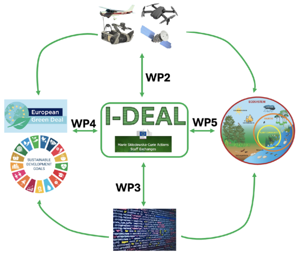
Overall structure of the i-DEAL project, organized into interconnected work packages that combine Earth observation, digital technologies, and geospatial services to strengthen ecosystem resilience.
Funded by:
Imatge

| Project funded by the European Union under the Horizon Europe programme, within the framework of the Marie Skłodowska-Curie Actions (MSCA) Staff Exchanges, aimed at promoting international mobility and knowledge exchange between research and innovation organisations. |