
 Contact


The geological timechart is the frame in which the history of the Earth is inscribed
The Geological timechart is the frame in which the history of the Earth is inscribed. It combines a numerical scale that uses as a unit the million years (chronometric scale) and a scale which is expressed in units of relative time (chronostratigraphic scale).
The chronostratigraphic scale is established by convention and is based on the International Standardized System of stratigraphical units (for example, "Jurassic", "Paleocene" or "Hildoceras bifrons ammonite zone"). This system, regulated by the International Commission on Stratigraphy (ICS), describes the relative divisions of geological time (eons, eras and their sub-divisions), establishes the limits of the units and calibrates them with the chronometric scale, attributing to them the corresponding absolute ages.
The chronometric scale is based on the measurement of determined physical properties of the rocks, generally the relationship between the content in stable isotopes and unstable isotopes of a same element (for example: 40Ar/39Ar), or the relationship between the contents in determined elements generated by radioactive decomposition of other elements (for example: U/Th/Pb, Rb/Sr or K/Ar). Using appropriate measuring techniques, an absolute age that is measured in years back from the present is obtained. These results show uncertainties typical of geochronological methods. For example, the start of the Cretaceous period was established, in 1982, as 130 ± 3 million years counted from the present, while in the current Table (2004) it has been established in 145.5 million years.
The chronostratigraphic scale is based on the principle of superimposition of the strata: the strata of sedimentary rocks that contain modern fossilized organisms are found above the strata of the sedimentary rocks that contain remains of older fossilized organisms. In a group of strata that are characterized for containing some determined fossil remains (fossil record) the lower strata show an older fossil record than the upper strata. If a name is given to each one of these groups of strata a chronostratigraphic scale, at least of local validity, is obtained. The proliferation of such validity units limited to local areas, soon made clear the need to establish some standard units that had a global validity, to each one of which the ICS agreed to give a name.
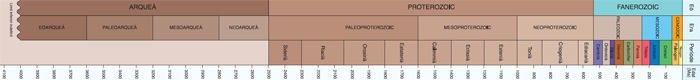
Applying the mentioned methodology, the history of the Earth was subdivided into three larger units or eons, which from the oldest to the youngest are: Archean (between 4 000 million years and 2 500 million years); Proterozoic (between 2 500 million years and 542 million years) and Phanerozoic (between 542 million years and 0 million years; the present time). Often, the two first eons (Achaean and Proterozoic), group themselves into an informal unit called "Precambrian".
The Phanerozoic eon is divided into three minor units or "eras" which, from the oldest to the most modern are called:
- Era Paleozoica o “Paleozoic” (between 542 million years and 251 million years), which includes six periods that go from Cambrian, at the bottom, to Permian at the top.
- Mesozoic era (between 251 million years and 65.5 million years), which includes the periods called Triassic (between 251 million years and 199.6 million years), Jurassic (between 199.6 million years and 145.5 million years) and Cretaceous (between 145.5 million years and 65.5 million years).
- Cenozoic (between 65.5 million years and 0 million years; the present time), which includes the periods called Paleogene (between 65.5 million years and 23.03 million years) and Neogene (between 23.03 million years and 0 million years; the present time).
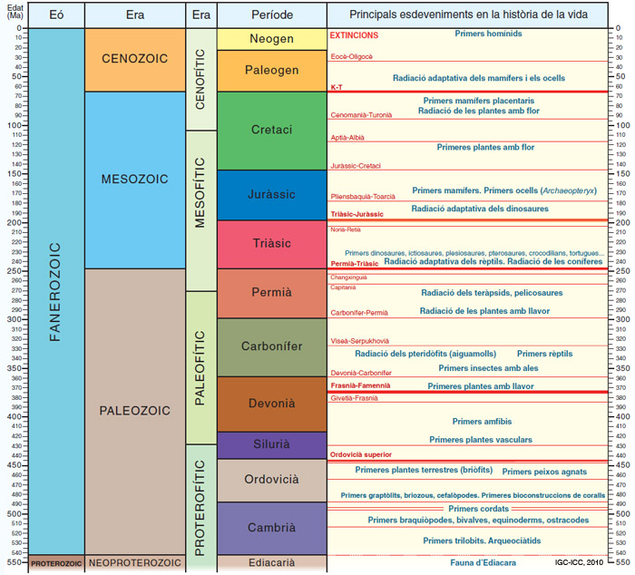
Each one of the periods are subdivided into various “epochs”, which generally are named according to their position within the respective period (for example, Early Cretaceous, between 145.5 million years and 99.6 million years) or they have their own name which is valid today (for example, Eocene, between 55.8 million years and 33.9 million years) or sometimes they preserve their obsolete names (for example, early Jurassic or Lias; Middle Jurassic or Dogger).
The epochs are subdivided into minor units called ages (for example, the Kimmeridgian is an age of the period of the late Jurassic or Malm).
With regard to the origin of the nomenclature of the various units, the names of the eons and of the eras make reference to the types of life that developed on the Earth at those moments (for example, "Mesozoic", from the Greek “middle life"). The periods are named, either by their stratigraphical position (for example ("Upper Triassic", which means that it is stratigraphically situated on top of the Middle Triassic"), or they have a complex history which includes considerations of a personal nature of the authors who defined them (for example, "Miocene", used by Charles Lyell in 1833, to refer to the second lower division of the four that he established in the south-western area of the Paris basin). The ages generally take the name of the area where the "stratotype" or stratigraphical series pattern has been described (for example, Maastrichtian indicates that the pattern section was defined in Maastricht, Netherlands).
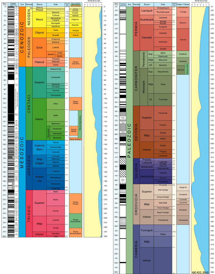
The Geological Time Scale includes some columns formed by black and white horizontal bands which represent the magnetic polarity at a certain moment of the Earth’ history (magnetostratigraphy). The magnetostratigraphical column records the inversions of the magnetic field of the Earth along the geological times. In this column, the black bands indicate "normal polarity" (this means that the magnetic north pole is in the vicinity of the north pole of the Earth’s rotation axis) and the white bands indicate "reverse polarity" (the magnetic north pole is in the vicinity of the south pole of the Earth’s rotation axis). The various "chrons" or units of time are formed by a combination of events "normal" and "reverse” that can be correlated with the chronometric scale and with the chronostratigraphical scale. Measuring the orientation of certain magnetic mineral particles, which many rocks contain, the “chrons” can be identified and, in this way, rocks that do not contain fossilized remains can be dated.
Finally, the Geological Time Scale includes two more columns. One, called "sea level" and situated correlatively beside the columns of the Paleozoic, the Mesozoic and the Cenozoic, represents the variations of the sea level during these eras. This curve, which is obtained by carrying out some analyses of a stratigraphical type on a global scale, allows us to see that the level of the sea has almost always been over the current level (for example, 80 million years ago, the sea level was around 350 metres above the today’s level). The other column placed to the right of the detail of the Neogene, carries the heading "18OPDB sea water (in parts per one thousand)". This curve has been obtained by analyzing, on a global scale, the amount of isotope 18 of the oxygen that is found in the carbonatic shells of certain unicellular organisms of marine life. In the warm climate periods, the amount of O18 that accumulates in the shells of these organisms diminishes and in the cold climate periods, this amount increases. In this way, a curve that shows a cyclic tendency is obtained, with some maximum peaks (for example, 2, 4, 6...), which correspond to the cold periods and some minimum peaks (for example 1, 5, 7, 9) which correspond to the warm periods.
Graphically, in the Geological Time Scale the chronostratigraphical units (eons, eras, periods and ages) are represented through a colour chart which follows the international regulations of UNESCO (for example, the Triassic is represented in reddish tones; the Jurassic in a scale of blues or the Cretaceous in a scale of greens).
Detail of the Phanerozoic
The Geological Time Scale used by the Cartographic and Geological Institute of Catalonia in the realization of the geological maps it produces is an adaptation of the Scale elaborated by the International Commission of Stratigraphy (ICS), published in 2004, to which they have added, conveniently calibrated, the ages of the materials of continental origin and the facies in current use in Catalonia. The colour chart is useful for coding the relative ages of the cartographic units represented in the geological maps. This Scale was approved by the ICS in 2005.
The Geological Time Scale: Detail of the Phanerozoic
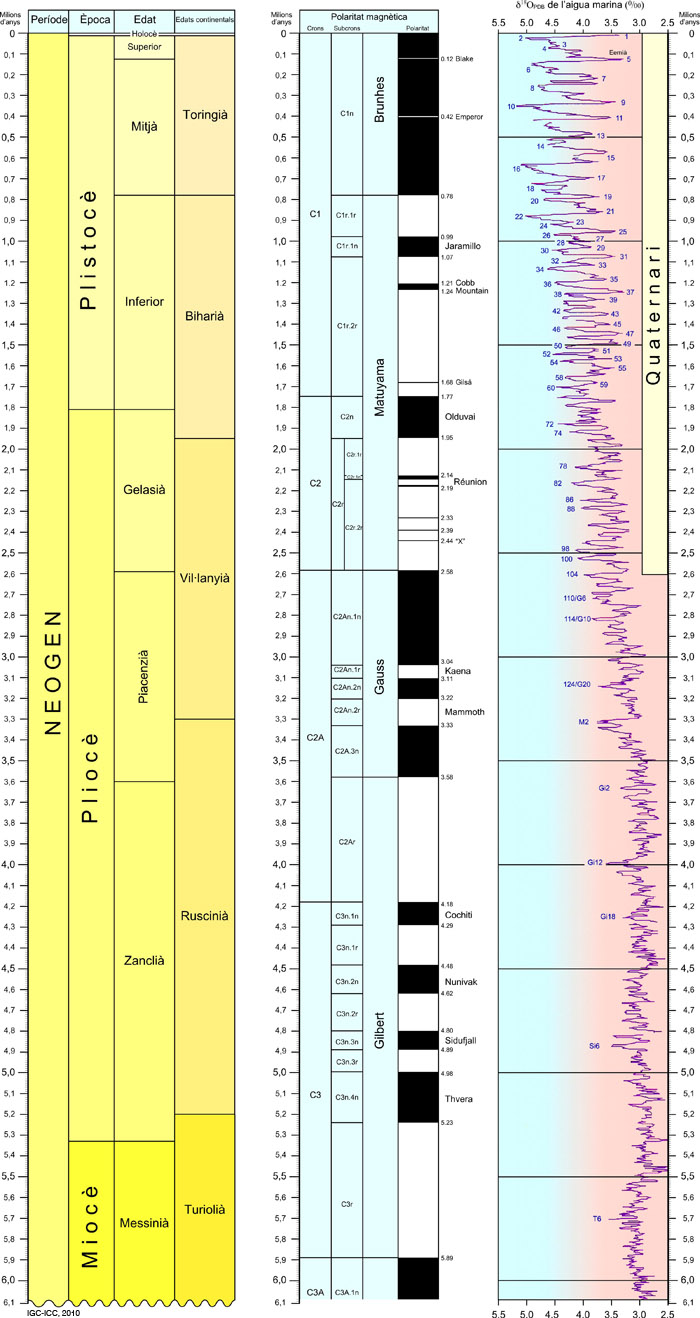
Detail of the last 6 million years
