
 Contact


Seven million years ago, an extraordinary event affected the whole of the Mediterranean basin and the emerged land that surrounded it: in the Messinian, the Mediterranean dried up. The major part of the area was converted into a gigantic salt flat situated at hundreds of metres below the level of the Atlantic. It is possible that the landscape was quite similar to a kind of combination of the Afar triangle with some of the salt flats of the Andean area and of the Dead Sea basin. That brutal change in the base level provoked the rivers to channel very deeply into the old marine platforms and the erosion they caused in the areas of the headwaters progressed towards the continent (figure 15).
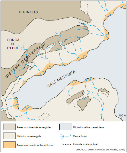
Figure 15: Reconstrucció paleogeogràfica a finals del MioPaleogeographic reconstruction in late Miocene
It was probably then when the headwaters of some of the streams that drained the reliefs of the Catalan Coastal Mountain Range towards the Mediterranean reached the Ebro Basin, capturing fluvial courses from this and constituting new hydrographic basins: those of the Ter, Llobregat, Francolí and Ebro. From that moment on, the old basin of the Pyrenean foreland stopped being an endorheic basin and passed to be a tributary of the Mediterranean basin. The eocene and oligocene sediments deposited in the Ebro Basin during the formation of the mountain ranges that delimit it, started to be eroded and to be converted into the source area of the majority of the materials that filled the Gulf of Valencia and the abyssal plain of the Gulf of Lion.
At the beginning of the Pliocene, the connection between the Atlantic and the Mediterranean had been re-established. By mid Pliocene, some 3 Ma ago, the level of the sea had not only been recovered but it had risen around 100 metres above the present level, sufficient enough for some of the tectonic graben areas close to the coast to be once again invaded by a shallow sea (figure 16).
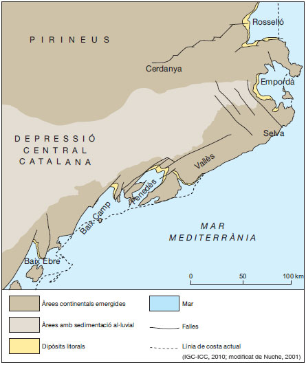
Figure 16: Paleogeographic reconstruction during the lower Pliocene, 4 Ma ago.
In the mouths of some rivers, some small Gilbert-type deltaic systems were formed. These are typical of the Mediterranean Pliocene. On the edges of the intermontane depression of La Selva, basaltic volcanic effusions of certain importance were produced.
