
 Contact


In the middle Cretaceous, some 47 Ma ago, the Pyrenees were a series of islands lined up in an west-east direction, which emerged among the waters that cover the foreland basins of Aquitaine, to the north, and of the Ebro, to the south. At that time, the Ebro Basin was an extensive bay which opened into the Atlantic through the Bay of Biscay and limited to the east with the reliefs of the Catalan Coastal Range, in such a way that it was disconnected from the Tethys Ocean. Flanking the Ebro Basin a detrital marine platform was developed where some reefs grew, at the same time as coastal and fan deltas were formed in the mouths of the rivers that drained the Catalan Coastal Range, the remains of which are the mountains of Montserrat and Sant Llorenç del Munt. The climate, the circulation of waters and the rest of the paleoenvironmental conditions, helped those platforms to be colonized by benthic life foraminifers typical of the middle Eocene, the nummulites.
The Ebro Basin slowly became filled with sediments. Towards the late Eocene, some 37 Ma ago, it has passed from being connected to the open sea through the Bay of Biscay to a practically endorheic regimen which favoured the evaporation (figure 11). This determined that in the central areas of the basin, large quantities of salts were deposited, while in localised marginal areas, small coral reefs were still being formed.
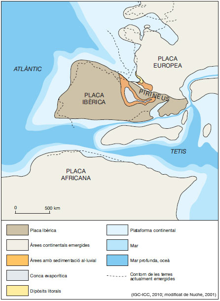
Figure 11: The restoration of the Iberian Plate some 37 Ma ago, towards the late Eocene
At the same time, the tectonic structures that were formed as a consequence of the collision of Iberia and Europe continued to extend towards the interior of the Ebro Basin, involving sediments that were increasingly younger. At the same time, this caused the space occupied by the Ebro Basin to become progressively smaller and also that the emerged area of the mountain ranges in formation were increasingly more extensive (figure 12). As a consequence, the volume of available materials to be eroded and transported towards the foreland basin increased.
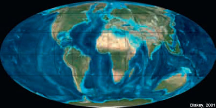
Figure 12: The configuration of the Earth some 35 Ma ago, in the Oligocene.
In the early Oligocene, approximately 33 Ma ago, the Ebro Basin, isolated from the Bay of Biscay and Tethys, was a depression subjected to an endorheic continental regime, which received the contributions of the rivers and streams that drained the areas of the north and the south, topographically elevated by tectonic causes. When arriving at the plain, those rivers and streams deposited their alluvium, consisting of enormous quantities of gravels, sands and clays, in the form of systems of alluvial fans and plains through which some rivers with braided beds meandered. In the central areas of the basin, relatively far from the fronts of the mountain chains, swamps and lacustrine areas developed where marl, carbonates, gypsum and, sometimes, peat were deposited. It is in these deposits where the remains of small rodents are found, an indication of the radiation of mammals. In the mouths of the water courses that arrived to those lakes, small deltas were formed. Probably, the landscape of the central areas of the actual Catalan part of the Ebro Basin should remind us, in some aspects, of the actual African Savannah: shallow lakes surrounded by vegetation and temporarily swamped areas.
