
 Contact


Throughout the early Cretaceous, the opening of the Atlantic Ocean spread towards the north producing the definitive separation of the North American Plate from the Iberian and the European ones. At the end of the early Cretaceous, 100 Ma ago, the Iberian Plate was completely individualized from the surrounding plates, limited by large strike-slip fault areas (figure 8). The northern limit was situated in the Pyrenean trough, where the separation of Iberia and Europe had provoked the opening of the Bay of Biscay and, towards the east, the formation of many narrow, relatively deep basins, connected with each other, which extended towards the eastern areas of the actual Pyrenean zone.
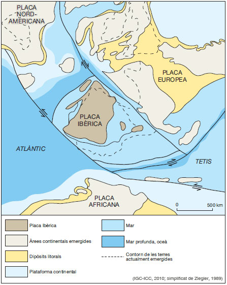
Figure 8: Restoration of the Iberian Plate 100 Ma ago, at the end of the Late Cretaceous
The separation between Iberia and Europe throughout this area was greater in the west than in the east, which added an anticlockwise rotational movement to the displacement of the Iberian Plate. To the south, another fault area connected that of The Azores-Gibraltar with the Alpine area. The spread along the Central Atlantic Ridge situated Iberia at some 800 km to the west of Newfoundland.
The emerged surface of the Iberian Plate had increased considerably since the late Jurassic and included a great part of the Iberian Massif. In the areas where the ancient Jurassic carbonate platforms emerged, systems of caverns and dolines were developed under a tropical climate which favoured the formation of bauxitic and lateritic soils. On the coasts which opened to Tethys Ocean and to the Bay of Biscay large deltaic fans developed with extensive marshland, which contained a great diversity of fauna and flora. On the continental platforms, away from the deltaic influence, carbonates and barrier reefs of rudists and sandbanks were deposited, many of the latter formed by the accumulation of the skeletal remains of some foraminifera characteristic of that time, the orbitolines. In the deeper marine troughs, situated in the northern and western zones of the Pyrenean area and of the Bay of Biscay, clastic sediments were deposited and transported by turbidity currents from the frontal part of deltas. In those oceans the ammonites proliferated.
Towards the middle of the late Cretaceous, around 85 Ma ago, the African Plate started a rotational movement in an anticlockwise direction in relation to the European Plate and, at the same time, it moved towards the north. This provoked the progressive closing of a part of the Tethys Ocean (figure 9).
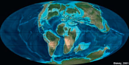
Figure 9: The configuration of the Earth 90 Ma ago, in the Early Cretaceous.
La Placa Ibèrica, situada entre la Placa Africana i la Placa Europea, es veié empesa cap al nord, iniciant-se la convergència amb la Placa Europea i la conseqüent deformació dels marges contigus d'ambdues plaques. A l'àrea pirinenca, la deformació es propagà des de les zones orientals cap a les occidentals, en un procés que culminaria, al cap de 50 milions d'anys, amb l'edificació dels Pirineus i de les cadenes alpines de l'interior de la península.
En aquells temps, l'àrea emergida del Massís Ibèric havia assolit una superfície propera a la de l'actual Península Ibèrica. A les desembocadures dels grans rius s'edificaven aparells deltaics, i a les àrees de la plataforma continental que quedaven fora de l'abast de les zones d'influència deltaica es dipositaven carbonats i margues i s'hi desenvolupaven esculls de rudistes i coralls. La deformació que patia la vora septentrional de la Placa Ibèrica provocava freqüents situacions d'inestabilitat en els sediments que es dipositaven en la plataforma continental. Una part d'aquells sediments eren transportats mitjançant corrents de turbidesa i colades de fang submarines fins als fons marins profunds del solc pirinenc.
